-
While Stormtrack has discontinued its hosting of SpotterNetwork support on the forums, keep in mind that support for SpotterNetwork issues is available by emailing [email protected].
You are using an out of date browser. It may not display this or other websites correctly.
You should upgrade or use an alternative browser.
You should upgrade or use an alternative browser.
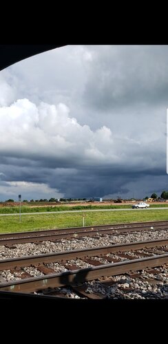
Scud Bomb? Need help identifying this...
- Thread starter Trevor Shepard
- Start date
Bob Schafer
EF5
It definitely looks like scud to me. What gives it away isn't the part that kind of looks like a tornado, it's the clouds around that part, which don't look right at all for if there was a tornado.
Marshall Stoner
EF1
Non-rotating multi-cell thunderstorms often produce updraft lowerings that look very similar to lowerings associated with supercells. That would be my guess as to what this is, but it can be hard to judge from still pictures. Whether the lowered clouds are associated with persistent rotating motion is more important than how impressive they look in a picture IMHO. Plains storms almost always look way more visually impressive than this, but wimpy pathetic looking storms can put down small twisters sometimes, especially low-topped supercells from upper cut-off lows or landfalling tropical systems. That said, this looks like a multi-cell feature to me just because the broader cloud base surrounding it doesn't have any curved features at all and is also quite small. A healthy supercell, even low-topped, will usually have a wider more uniformly dark base. The way the scud/lowering looks isn't as important as the appearance of the overall cloud base.
TJKLECKNER
EF4
Bob Schafer
EF5
Marshall Stoner
EF1
Yea. That's a good example of a really ominous looking non-tornadic cloud. Sometimes from a head-on perspective an inflow feeder will look like it's lowered vertically to the ground when it's actually tilted and descending at a shallow angle towards the horizon. An RFD shelf can also create an eerie wedge appearance in the distance when you're looking along it from a cross-section point of view instead of head-on.I was a noob in my 3rd year of chasing, and I was totally fooled into thinking this was a big tornado over Dodge City. Scud.
Steve Holmes
EF2
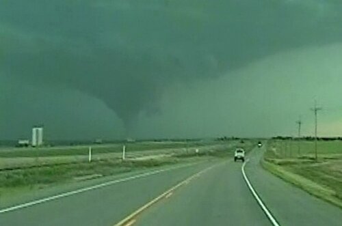
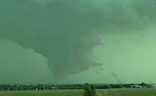
Your pictures should be part of every NWS spotter session. They show how easy it is to get fooled. (I'm too embarrassed to post the scud that hoodwinked me in my earlier days.Here are two images of mine from May 27, 2001.
View attachment 19578
View attachment 19579
I was a noob in my 3rd year of chasing, and I was totally fooled into thinking this was a big tornado over Dodge City. Scud.
Bob Schafer
EF5
Now I am kind of hijacking the thread, and I sincerely apologize, but I want to tell you more about the story of my scud. This isn't the first time I have posted those vidcaps on ST. I posted them on ST the night of May 27, 2001, the day I shot the video, proudly showing everyone the "big tornado" I had seen. It wasn't until the next day that I was smacked down, and I was humiliated. Don't worry about it, Steve. You gotta be able to laugh at yourself.
ChristofferB
EF2
- Joined
- Aug 27, 2009
- Messages
- 197
This has got to be the most tornadic looking scud or cloud feature I have ever seen.
I'm inclined to agree with Marshall, it does look like convective rain-free base (a non-rotating wall cloud), likely from a developing multicellular storm. Unless it was rotating, in which case it was likely an isolated rotating wall cloud within a convective eddie; it is attached to the cloud base, so in theory it could absorb surface based vorticity and form a non-mesocyclone tornadoIm not sure this is the right place to post this. I have a strong inclination that this is a scud bomb, it came from the base of some weak afternoon convection. View attachment 19182
Here are two images of mine from May 27, 2001.
View attachment 19578
View attachment 19579
I was a noob in my 3rd year of chasing, and I was totally fooled into thinking this was a big tornado over Dodge City. Scud.
Are those striations not from rotation then? Scud clouds don't rotate and there are plenty of tornado reports from Western Kansas that day. Most chasers aren't meteorologists and don't always know what they're looking at, especially when you saw something they didn't. When I'm not sure what I saw I usually run it by an NWS meteorologist and/or a few local television meteorologists, and possibly a few spotters I trust, then use the consensus to determine what I saw. I'd be extremely curious to see that video if you still happen to have it.
Bob Schafer
EF5
As I remember it now, my chase had started around Liberal. Somewhere west of DDC, anyway. Because I didn't know what I was doing I ended up chasing the FFD region of the storm, which is what you see in my pics. I do have the video, but not with me. I'm not home. The video does not exhibit any rapid rotation. That scud may have been rotating slowly, but of course that is meaningless. It appeared to me to be right over DDC, not just nearby, so it was likely within 5 miles of the DDC radar, if not less, yet the mets at the office there never issued any warning. I have to believe they were looking at it right out their windows. There was no tornado reported there, no damage.
Ah yes, but such inflow feeders can also be adjacent to a tornado, and could easily shroud one from the wrong angle as well, I personally think video is a far more reliable as it shows motion.Yea. That's a good example of a really ominous looking non-tornadic cloud. Sometimes from a head-on perspective an inflow feeder will look like it's lowered vertically to the ground when it's actually tilted and descending at a shallow angle towards the horizon. An RFD shelf can also create an eerie wedge appearance in the distance when you're looking along it from a cross-section point of view instead of head-on.
Now I'm REALLY curious to see your video! Would you mind doing a private upload and sharing it on this thread when you get home? There shouldn't really be any rotation at all in scud, sure, they can briefly swirl around eachother in a disorganized fashion now and then, but the discernment between scud and something threatening is rotation within the cloud (and not simply clouds caught in rotation), not to mention that NWS clearly defines scud as disconnected from the cloud base. Maybe you saw a developing shelf with scud inflow, but I'd be hard pressed to call that entire structure scud. . .As I remember it now, my chase had started around Liberal. Somewhere west of DDC, anyway. Because I didn't know what I was doing I ended up chasing the FFD region of the storm, which is what you see in my pics. I do have the video, but not with me. I'm not home. The video does not exhibit any rapid rotation. That scud may have been rotating slowly, but of course that is meaningless. It appeared to me to be right over DDC, not just nearby, so it was likely within 5 miles of the DDC radar, if not less, yet the mets at the office there never issued any warning. I have to believe they were looking at it right out their windows. There was no tornado reported there, no damage.
Bob Schafer
EF5
Okay, I'll plan to upload it when I get home, which should be toward the end of next week.
Bob Schafer
EF5
Done, finally. I just got home Friday. I muted the audio because it features my old nowcaster's voice on a speaker, and I didn't want to bother taking the time or effort to try to reach out to ask his permission to put his voice on the internet. He used to be an ST regular, but I don't think I've seen anything from him in at least several years. Anyway, you really don't need to hear the audio.
First time ever this video has been on the internet. YouTube didn't exist in 2001!
First time ever this video has been on the internet. YouTube didn't exist in 2001!
So bizarre! It almost looks like there might be weak rotation embedded in the left side of the lowering, however, I can concur the structure as a whole isn't rapidly rotating. I'd say that's most likely an inflow tail, but it could be a wall cloud with inflow pulling in from the right side. I don't mind the lack of audio, I love the footage for being nostalgic enough! haha 2001 the era of Stupidvideos and eBaum's World, not the best places to post storm chasing footage!Done, finally. I just got home Friday. I muted the audio because it features my old nowcaster's voice on a speaker, and I didn't want to bother taking the time or effort to try to reach out to ask his permission to put his voice on the internet. He used to be an ST regular, but I don't think I've seen anything from him in at least several years. Anyway, you really don't need to hear the audio.
First time ever this video has been on the internet. YouTube didn't exist in 2001!
Similar threads
- Replies
- 7
- Views
- 630


