Luke Datsko
Enthusiast
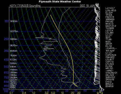
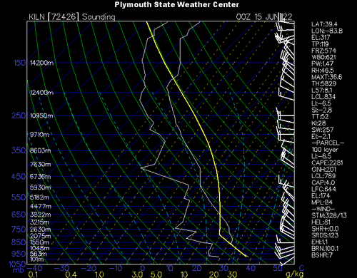
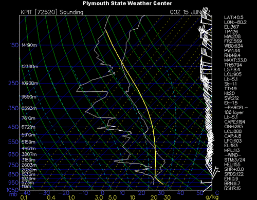
On June 14, 2022, an atmospheric sounding on the HRRR model for 21z, F000 near Mansfield, Ohio (in the file I attached) shows a SBCAPE value of 8560 J/kg, and a MLCAPE of 6818 J/kg. I assume that the real CAPE most likely wasn't that high; however, what ended up occurring after this reading was taken was pretty much nothing (except a few cumulus clouds), so I'm struggling to understand why not much happened on this day with such high CAPE values.
I know that in order to initiate thunderstorm growth, there needs to be a source of lift (such as a trough, front, etc.); however, I also know that when the CAPE is high enough it can initiate storm growth on its own (in addition, there was a warm front ahead of the unstable air which could have provided lift). There was also no convective inhibition, and the LFC and LCL were at the same level. If I had to make a ball park guess to why there was no storms it would either be there was an extensive area of large CAPE values on this day (I forgot to take images of this, sorry), or there was an 'upper-level high' preventing storm growth (there were Excessive Heat Warnings for much of the US on this day).
I am mainly just wondering if there is any way to tell from just the Skew-T that there would be no storms occurring. I also attached a satellite image from this day, as well. The sounding was taken from an area just southwest of the band of clouds marking the warm front (near where it says Ohio). Thanks for your help!