Nonsupercellular Tornado Encounters

Max Olson

EF0
Joined
Apr 15, 2013
Messages
13
Location
Parker, Colorado
Well, it may not be the type of tornado every chaser goes out in search of when they hit the road for their chase trip, but these “oversized dust devils” can be a highlight of chasing in areas on the high plains. If you are a Colorado chaser, you probably know what I am talking about, our geographical features such as the Palmer Divide interacting with Southeasterly flow can make for fun and rewarding afternoons along the DCVZ boundary that sets up. However, my question to everyone has have you ever actually seen one and if so what is your story? Once you get in places east of I-35, these things are pretty damn rare. If you did see one, would you add it to your tornado count (I know they are officially tornadoes, but some people really dismiss will landspouts). Personally, I love them… Last year on May 7th, while most chasers were chasing supercells Texas or Oklahoma along the dryline, we were near Akron, CO enjoying a “Spoutfest”
10456255_652431548165530_1638214934117169275_n.jpg
11001918_797259423682741_5358912361629949757_n.jpg
 
I'm a big fan of the water variety. If the conditions are right I'll head up to Lake Michigan: typically 15C difference between 850 mb and the lake surface. A land breeze over the lake and cut off low or stacked low over the lake seem to make for spout outbreaks (spoutbreaks?). 3km CAPE seems to be a good discriminator for spout setups too.

12092204.jpg


This one actually made landfall and was rated as an EF0 tornado by the Grand Rapids NWSFO.
12092201.jpg


Spout spotting is a really enjoyable outing and much more relaxed compared to supercell chasing. An analogy might be like going to a baseball game instead of playing baseball. You're watching the action from afar on the beach, but it can still be exciting.

I've been on the look out for non-supercellular spouts and cold air funnels and tornadoes, but haven't had any luck yet. I don't spend enough time in the high plains either though. Maybe I should just camp out at DIA. I've caught a couple landspouts from supercells and seen some cold air mini supercell funnels, but nothing out of a non supercell updraft. It seems like such a crapshoot trying to catch them. They're so brief, you don't have the visual cues and data guidance, and can be like catching a needle in a haystack if there are a lot of updrafts.
 
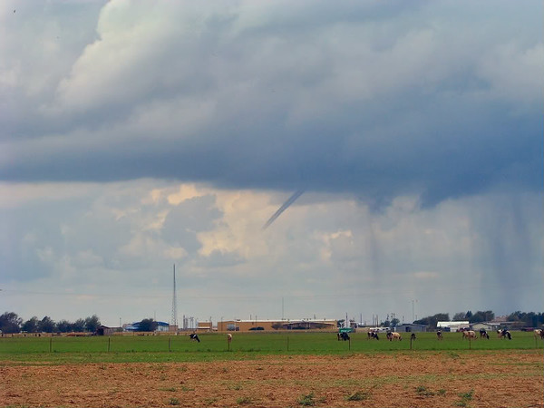
This was a cold air funnel that I believe touched down near my hometown of Hereford, TX after a cold front passed over a very moist air mass. This is a rare event for us here in Texas. It only happens when a tropical system comes over the area.
100_1218.jpg
 
"Midwest magic" can produce non-supercellular funnels and tornadoes, many of them on zero-tornado risk days. I saw this one under a rain shower that persisted for 14 minutes back in August of 2013. I'll bet I would have found a discernible ground circulation under it if I had tried to get closer.

aug1213at.jpg


Old outflow boundaries here in Illinois can produce some surprise landspout events even during the summer low-to-no-flow days. One of those last year in Fairfield, IL was quite photogenic, with a nearly 2/3 condensed funnel connected to the dust tube.

This is one reason I love chasing general t-storm days here in Illinois. Every once in a while one is going to produce something, and I have a shot at seeing it if I can catch the subtle boundaries that make them happen.
 
Back
Top