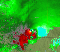
Most violent tornado in history?

I think the upward forces in tornadoes aren't well appreciated. Even an ef-2 can pull a tree out of the ground and loft it hundreds of feet in the air. A tornado I was chasing lifted up a washer and drier out of a mobile home but left the walls standing.
It's certainly unusual, but it's not entirely unprecedented, at least in terms of the basic evolution of the event. I was doing some research when I wrote my blog and came across a handful of events that featured similar basic pieces (extreme instability in the presence of modest shear, gravity waves and a tornadic supercell sorta back-building along a boundary like a zipper). Except, you know, those events didn't happen to feature one of the most intense tornadoes ever recorded. :D

I don't think I have any of that info on hand, but I can try to find it if you'd like.

Concerning the parking stops, the NWS survey said they weighed "approximately" 300 pounds. I don't know where they got that figure from, but it's possible. It seems most of them weigh between 200 and 275 lbs from what I've seen. Another thing I noticed is that the rebar "anchoring" appears to literally be pieces of rebar. Most of the time, at least with modern parking stops, they use a pin with a head on it that looks sorta like a really big nail. I don't know how much difference the head would make in practice, but it seems like it'd provide a little more anchoring and resistance than just a straight piece of rebar.

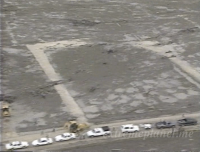
Anyhow, this is what I was talking about. Note how the stops seem to have been twisted more so than torn away.

1bb67b2bc669f64b91d0ddabb109251b.png

d7ab39c14c489bbe66c4bb6bfbf06a4d.png

3360bfb62b5050632799eacd744e480b.jpg

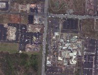
Location of photos in 1-2-3 order:

2116457ec9098eb47f7630bc858cc57f.jpg
The movement of anchored concrete parking stops is by far the most impressive tornado damage I think I've ever seen. I always envisioned surface friction would temper tornadic wind speeds that close to the ground. Normally a parking stop wouldn't need bracing against vertical movement, hence the lack of the 'nail head' on the rebar. It's interesting that all of the stops look like they twisted off as they moved, as each stop's rebar is bent in opposite directions. I think Shane's theory is probable - could this have been a subvortex that traveled right along the line of stops, plucking each one as it went?

And is it certain that those are concrete stops? They make them out of plastic and rubber in the same colors.

eft the walls standing.
 
Maybe in terms of energy because it seemed like ef-3 damage made up half or more of the total area covered.

The Joplin tornado left a very wide path of violent-level damage. There were also a lot of poorly built structures, but I think the contextual evidence (scouring, extreme debarking/denuding, debris granulation, incredible vehicle damage, etc.) points to a tornado that was not only exceedingly intense, but intense over a relatively wide area. It's hard to know quite what to make of it, though. On one hand, the fact that it caused such extreme destruction in such a (relatively) populated/built-up area makes it even more impressive, since there's more "stuff" in the way that you'd think would slow the wind speeds near the surface. On the other hand, all that extra "stuff" contributes to much heavier debris loading, which increases the destructive force of the wind even if the velocity decreases.

As I'm sure I've mentioned before, probably the greatest extent of violent-level damage I've ever seen reliably documented is the Hackleburg - Phil Campbell EF5. It produced extremely violent damage, at times very wide, over huge swaths of its 132-mile path. It first caused catastrophic damage in the Hackleburg area, weakened briefly, again attained violent intensity near Phil Campbell and more or less maintained that intensity for the next ~65 miles into western Madison County. The intensity fluctuated slightly and appears to have occasionally dipped below the violent threshold, but that path from eastern Franklin to western Madison County is probably the greatest stretch of near-constant violent tornado damage I can think of in modern times.

Obviously it's quite possible (and in the case of the Tri-State, I'd say probable) that other historical tornadoes could have matched or exceeded it, but there's so little documentation for rural areas between towns that it's hard to say.

I think the upward forces in tornadoes aren't well appreciated. Even an ef-2 can pull a tree out of the ground and loft it hundreds of feet in the air.

The wind flow within tornadoes in general isn't all that well-understood. It's extremely chaotic, and the information we can infer from damage surveys is only a fraction of the real story. We can look at the aftermath and estimate that any given instance of damage was caused by wind speeds in a certain range, but it doesn't necessarily tell us anything about what the winds were actually doing. Some of the modeling that's being done is super interesting, but even then I'm not sure it really captures the complex mess that is tornadic winds - intense updrafts and downdrafts, subvortices (and hell, probably subvortices within subvortices and other assorted craziness), violent, sudden accelerations, extreme velocities occurring over very short spacial and temporal scales, etc. Damage doesn't tell us much about all that to begin with, but it's made even more difficult by the fact that so few tornadoes actually hit anything substantial, and even of those that do, the damage often occupies only a very small portion of the path. Probably less than 1% of the cumulative area of all tornadoes' paths contain any sort of significant structures. Even if you include trees and such, I'd imagine that percentage is still extremely low.
 
You have already done so much, but if you have info on setups similar to Jarrell - AND you don't have to do too much digging.....
I am super curious about these setups where you get basically one big giant violent storm, and pretty much nothing else.

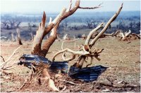
Obviously I'm waaaay late on this, but I just realized there's one textbook case that I've apparently never mentioned here. It's relevant here specifically because it was pretty Jarrell-esque in its overall evolution, but it also appears to have been violent enough to warrant inclusion in a "most violent" discussion. So, if you'll excuse my hijacking this thread with another very long, picture-filled post, here's a story for you..

It was a clear, sticky day in May. By midday, temperatures had reached the mid-80s with dewpoints hovering in the lower 70s across most of the southern half of Texas. The atmosphere above didn't exactly scream "tornado outbreak," but strange things sometimes happen in this part of the country in the presence of strong instability. With that in mind, the SPC issued a rather large moderate risk encompassing much of the central portion of the state. The cap ruptured by mid-afternoon, sending a massive supercell billowing into the skies over the Hill Country. The storm drifted slowly at first, taking on an odd and highly deviant motion. New updrafts began to pop up on its southern flank, flaring to life only to merge with the existing mass of storms. Suddenly, a massive funnel descended from the clouds and began a slow, meandering path of destruction, scouring vegetation from the earth and demolishing anything that lay in its path.

Sound familiar? No, it's not Jarrell. This event occurred on May 11, 1999, over a desolate little stretch of southeastern Mason County near the tiny outpost of Loyal Valley. Officially, the tornado went into the books as an F4. Unofficially, the sheer intensity of the damage suggests it was capable of much more. It produced very intense ground scouring over most of its ~7-mile path. One observer later remarked that you could see the full path because it looked as if the tornado had "dragged itself" across the landscape, plowing up the ground as it went. This can partially be seen in the cover shot of the May 1999 issue of Storm Data, which frankly looks like a war zone.

97658294c257086a2796a5c019d0739b.jpg

You can also see the extreme tree damage that it caused, which is especially notable because most of these are mesquite. Mesquite trees are known for their ruggedness, as well as their strong and deep root systems, and yet this tornado completely debarked and denuded many of them, snapped some off very near the base, and in some cases tore whole trees from the ground and tossed them hundreds of yards. For instance:

a7b5ea773d6634495592867f67742099.jpg

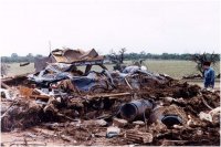
There were very few structures in the direct path of the storm, thankfully, but those that were in the path were completely destroyed. This is what was left of the home in which the tornado's only fatality occurred, and bear in mind that this home actually appears to have been slightly outside of the most intense core. A family of six sought shelter by driving their car into the garage (variously reported as being built from either stone or concrete); the home and garage were demolished and at least partially swept away, and the 74-year-old grandfather was killed when a 2x4 penetrated the car and impaled him. The others miraculously survived with relatively minor injuries.

33b377f5f45d71ded7ba4de3b1ffbecb.jpg

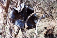
A new truck which was parked near the home was torn apart and scattered over three-quarters of a mile. Here's the hood of the truck several hundred yards away.

0d423094716bd22a7c16b72778237f54.jpg

In the same general area, the massive multivortex wedge (more than three-quarters of a mile wide at that point) scoured away more than 700 feet of asphalt from Ranch Rd 152, throwing chunks of it over a thousand yards. Hundreds of head of cattle were killed and badly mutilated, as were a number of horses, deer and other animals. An Air Force meteorologist who'd surveyed Jarrell two years earlier had this to say about the Loyal Valley tornado:

"Hecke said Tuesday night's tornado likely was an 'F-5' grade - the severest category, marked by winds of more than 260 miles an hour. 'The two homes that were destroyed, the foundations were gone. Trees were stripped of their bark, and 150 to 175 feet of pavement was stripped away' - which occurs only when windspeeds reach F-5 level."

And a TV reporter who'd also witnessed Jarrell said this.

"'I hadn't seen anything like that. I couldn't believe what it did to animals,' said Flores, who also witnessed the destruction at Jarrell. 'The subdivision in Jarrell that was hit by the tornado was wiped clean. This was wiped clean, too, but the cattle - their hides had been ripped right off of them. Some of them were missing heads, and some were caught up and entwined in barbed wire.'

'There was absolutely nothing left of it [the new pickup truck]. It looked like it had been blown up by a bomb or something. Two dead cows were lying at the foot of it ... their skin was gone. They were pink and purplish. No skin. It took the skin right off.'"
 
I can't find my video, so here is someone else's of the infamous Bonny Reservoir tornado:

" target="Alpha">Watch video >
edit: Seriously though, this is a tough question because you're comparing what are essentially poorly documented tornado myths (Tri state/Xenia/etc) with poor visibility (Greensburg, Bridge Creek, etc.). Do you take the largest amount of damage in the smallest physical area to infer intensity - letting Elie and Pampa win?

Although "only" an EF-4, Tuscaloosa is one of the most evil looking tornadoes to me, and reminded me a lot of Andover. Any time you get those rolling horizontal waves and appendages, that's nature's way of saying "back off". Manchester and Bowdle looked pretty wicked too, and might have gone higher than 4s if they actually hit anything.
Tuscaloosa Videos are just plain nasty. A very visible violent +FC in the middle of a highly populated area. Just the motion on the funnel makes it a memorable twister.
 
Anyone have any video or images of the ef-4s in pa in May 85? ie the one that was 64 miles long and very wide and showed the first debris ball?
 
In my opinion the Jarrel Tx tornado back in 1997 could be the most violent. The tornado of course was rated an F-5, but what made it so violent was the fact that it was moving so slow. Pretty much everything that was above ground was completely swept clean. (See pic below) Virtually everyone who was in shelter above ground didn't survive. Very sad. The tornado (like many other violent tornadoes) contained very violent updrafts that sucked away grass in fields. (Here is a pic below) Other notible tornadoes that have done that type of damage in fields include the EF-5 Philadelphia Ms tornado back on April 27, 2011. But we have to remember that large tornadoes are not the only ones that can be very violent. The small suction vortices can be just as strong if not stronger as the bigger tornadoes. Here is a video of a tornado from Australia.


It was very small in width but when it interacts with friction you increase surface inflow and at the corner flow you can have 200+ mph winds. Dr. Lewellen and Dr. Fiedler stated that in some cases in that region some tornadoes that have the structure of cyclostrophic balance aloft and a cyclostrophic imbalance at the ground can have winds close if not exceeding the speed of sound. image.png image.png
 
This is slightly off-topic, but does anyone know what tornado was on the ground for the longest period of time? There seem to have been some very long-winded ones (pun not intended) that have been on the ground for several hours - the Tri-state tornado and Candlestick Park come to mind.
 
Construction practices, survey practices, vegetation, population density, etc., all influence tornado damage ratings, and they've all (likely) varied quite a bit from time-to-time and place-to-place. The mobile radars and WSR-88D give us some chance to compare the larger-scale tornado circulations, but frequent radar upgrades leave us with a moving target. For what it's worth, here are the 10 strongest rotational velocities we've found with US tornadoes since 2009:

1. Tuscaloosa, AL, EF4 4/27/11 124 kt
2. El Reno, OK, EF3 5/31/11 124 kt
3. Calhoun Co., AL, EF4 4/27/11 123 kt
4. Tipton, OK, EF3 5/16/15 116 kt
5. Woodford Co., IL, EF3 11/17/13 116 kt
6. Cedar Co., NE, EF3 6/17/14 111 kt
7. El Reno, OK, EF5 5/24/11 110 kt
8. Yazoo City, MS, EF4 4/24/10 109 kt
9. Menifee Co., KY, EF3 3/2/12 108 kt
10. Jackson Co., AL, EF4 4/27/11 105 kt

For comparison's sake, Joplin was 99 kt, and the latest Moore tornado was 92 kt. The biggest question with radar data is sampling compared to ground level and the size of the tornado, which are obviously not equal in all cases. There are clear relationships between rotational velocity and EF-scale damage ratings, but it's still far from perfect given all of the different ways things can vary.
 
Last edited:
Construction practices, survey practices, vegetation, population density, etc., all influence tornado damage ratings, and they've all (likely) varied quite a bit from time-to-time and place-to-place. The mobile radars and WSR-88D give us some chance to compare the larger-scale tornado circulations, but frequent radar upgrades leave us with a moving target. For what it's worth, here are the 10 strongest rotational velocities we've found with US tornadoes since 2009:

1. Tuscaloosa, AL, EF4 4/27/11 124 kt
2. El Reno, OK, EF3 5/31/11 124 kt
3. Calhoun Co., AL, EF4 4/27/11 123 kt
4. Tipton, OK, EF3 5/16/15 116 kt
5. Woodford Co., IL, EF3 11/17/13 116 kt
6. Cedar Co., NE, EF3 6/17/14 111 kt
7. El Reno, OK, EF5 5/24/11 110 kt
8. Yazoo City, MS, EF4 4/24/10 109 kt
9. Menifee Co., KY, EF3 3/2/12 108 kt
10. Jackson Co., AL, EF4 4/27/11 105 kt

For comparison's sake, Joplin was 99 kt, and the latest Moore tornado was 92 kt. The biggest question with radar data is sampling compared to ground level and the size of the tornado, which are obviously not equal in all cases. There are clear relationships between rotational velocity and EF-scale damage ratings, but it's still far from perfect given all of the different ways things can vary.
Just asking, but if Tuscaloosa and El Reno are on par and Tipton and Woodford are on par then why are Tuscaloosa and Tipton rated above El Reno and Woodford?
 
Just asking, but if Tuscaloosa and El Reno are on par and Tipton and Woodford are on par then why are Tuscaloosa and Tipton rated above El Reno and Woodford?

Tornadoes are rated by the damage they cause, not by their rotational signatures. If the strongest tornado ever recorded were to sit over an empty plot of dirt and not hit anything, it'd be rated EF0-EF1, regardless of how strong it actually was. In order for a tornado to be rated EF5, it has to 1) Hit a structure well-built enough to require EF5 level winds to sweep it off the foundation and 2) Actually be producing EF5 level winds at the time the tornado crossed over the structure, as EF5 level winds only occur for a very brief period of time and over a very small area in the majority of tornadoes that earn the rating. The only instance I can think of in which a tornado was rated EF5 due to damage not inflicted on structures was the Philadelphia tornado from 4/27/11, due to the fact that it dug a 2 feet deep trench through a field.
 
The Philadelphia, Ms tornado not only dug into the ground 2 feet but also tore up pavement, bent steel girders, and totally debarked trees. http://www.srh.noaa.gov/jan/?n=2011_04_25_27_neshoba_kemper_winston_noxubee

Do you have a source for this bit? I've never heard that and didn't see it on the NWS' survey page. It certainly wouldn't surprise me given it was obviously a violent, violent tornado, but I've seen relatively few instances of a tornado actually deforming steel girders (the one that sticks out most clearly in my mind being the 2008 Parkersburg EF5). Unless I'm imagining a different kind of steel girders than you're referring to, which is always possible.

Anyway, re: the rest of that stuff, while absolutely impressive, it doesn't necessarily equate to EF5 damage. Pavement scouring has been documented in relatively "weak" EF2 or EF3 tornadoes, and in a few cases even lower when the road in question is in poor shape. It depends heavily on how the road was constructed, how well it's maintained, whether and how much it's raised above the surrounding ground, etc. It's still impressive, but it may not take such violent winds to get up under any little imperfection in the road and just peel it right back. Ditto for tree damage. The scale as it currently exists assigns a maximum upper bound of 167 mph for a DOD5 (complete debarking and denuding, with only stubs of the largest branches remaining) for hardwood trees, which is basically right on the dividing line between EF3 and EF4. I recall reading somewhere that the SPC was looking at tree damage and whether they can expand on it, but that'd be pretty tough. There are so many factors - the particular species of tree, how deep-rooted it is, how healthy it is, soil and moisture conditions, etc, etc. - that influence how a given tree is affected by the wind. Debris loading is another major wild card that isn't easy to account for - a 150 mph wind filled with bits and chunks of debris, sand, etc. will almost certainly do a lot more damage than a 200+ mph wind with little to no debris. Wind duration probably plays a role as well.

The incredible scouring (more like trench-digging, honestly) kinda mystifies me. It doesn't look "scoured" so much as "plowed," with the grass and dirt sorta pulled up in big chunks and broken apart. Not really sure what to make of that one, but it's awfully damn impressive. I've only heard of similar things happening a couple times, and only with extremely intense tornadoes.
 
This is slightly off-topic, but does anyone know what tornado was on the ground for the longest period of time? There seem to have been some very long-winded ones (pun not intended) that have been on the ground for several hours - the Tri-state tornado and Candlestick Park come to mind.

I'd imagine it's got to be the Tri-State tornado, depending on where you fall on the path length debate. I don't think the 235 or 219 mile lengths are accurate, but even the conservative ~174-mile length that's well-documented would surely be the leader in the clubhouse. That'd probably put it somewhere just short of three hours. The Yazoo City EF4 was on the ground for very close to three hours as well, IIRC. The long-track Brandon, MS F4 on 11/21/92 was on the ground for just over 2.5 hours. There was a very slow-moving tornado in southwest Manitoba back in July of this year that was alleged to have stayed on the ground for 2.5 to 3 hours, but I haven't heard much more about it and haven't really looked into it. 1947 Woodward was likely on the ground for 2-2.5 hours, maybe a bit more depending on exactly where you put the touchdown and dissipation. Those are ones that come to mind, I'd have to think about some others.

Construction practices, survey practices, vegetation, population density, etc., all influence tornado damage ratings, and they've all (likely) varied quite a bit from time-to-time and place-to-place. The mobile radars and WSR-88D give us some chance to compare the larger-scale tornado circulations, but frequent radar upgrades leave us with a moving target. For what it's worth, here are the 10 strongest rotational velocities we've found with US tornadoes since 2009:

1. Tuscaloosa, AL, EF4 4/27/11 124 kt
2. El Reno, OK, EF3 5/31/11 124 kt
3. Calhoun Co., AL, EF4 4/27/11 123 kt
4. Tipton, OK, EF3 5/16/15 116 kt
5. Woodford Co., IL, EF3 11/17/13 116 kt
6. Cedar Co., NE, EF3 6/17/14 111 kt
7. El Reno, OK, EF5 5/24/11 110 kt
8. Yazoo City, MS, EF4 4/24/10 109 kt
9. Menifee Co., KY, EF3 3/2/12 108 kt
10. Jackson Co., AL, EF4 4/27/11 105 kt

For comparison's sake, Joplin was 99 kt, and the latest Moore tornado was 92 kt. The biggest question with radar data is sampling compared to ground level and the size of the tornado, which are obviously not equal in all cases. There are clear relationships between rotational velocity and EF-scale damage ratings, but it's still far from perfect given all of the different ways things can vary.

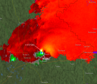
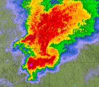
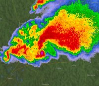
The Tuscaloosa radar presentation remains the most impressive I've ever seen, especially just east of Holt. Equal parts horrifying and awe-inspiring.

a60ab8bca64cf7800d5b92f1b51d20db.jpg

f2f1ff2d084d4175bf4f1a8c6098d6d7.png

One that I've brought up occasionally in other threads is a massive wedge near Mullinville, KS on May 23, 2008 (otherwise known as the Quinter Wedgefest), which got lost in the mix that day but was really impressive.

f10283ca7e22a8cb2ee15bde9a236951.png

4688cdba194bdc0df78fd235b2253e32.png
 
You must log in or register to reply here.

Similar threads

Back
Top