It's been over a month, so I'm not sure if you're still looking for an answer, but here goes:
Usually, when people are talking about "mixing," they're referring to parcels of air near the ground combining with parcels of air just above them, and then those parcels combining with the ones just above them, and so on. When two parcels mix, they exchange certain properties, most commonly
potential temperature and mixing ratio. This happens such that at the end of the mixing process, the two parcels have the same potential temperature and mixing ratio*. The most common driver of mixing is the sun ("diurnal mixing"), but it can be from other sources, too.
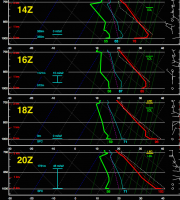
I've attached a progression of soundings launched from Yuma, AZ a couple days ago (specifically, 15 October 2015) that illustrate diurnal mixing a little bit. It starts off at 14Z, which is just after sunrise. The sun warms the surface, which warms the layer of air right next to the surface. Once that layer gets warm enough, it mixes with the air above it, which you can see happening by 16Z. You can also see the point right above the surface cool slightly between 14-18Z. That's because that air is being forced to mix with the surface air, which is cooler than it. By 18Z, heating of the surface has overwhelmed the ability of the mixing to transport the heat away, so you see the superadiabatic (lapse rate > 10 C/km) layer right at the surface below a bit of the residual cool layer. That superadiabatic layer is absolutely unstable, meaning any little shove upward (perhaps from stuff on the ground) will cause that air to rise and air from above to replace it; in the process they will mix. By 20Z (~45 minutes after local solar noon), the residual cool layer is completely mixed out, and that's essentially the afternoon temperature profile.

You can see kinda the same things happening in the moisture profile. The surface dewpoint jumps up to better match the dewpoint just above the surface between 14Z and 16Z: those layers are being mixed. Then you can see the low-level dewpoint generally gradually decrease throughout the day, as the mixing slowly grabs drier and drier air from aloft.
Anyway, if you have any questions or need something explained better, let me know, and I'll try to explain it better.
*Specifically, the mass-weighted mean of the potential temperature and mixing ratio from the original two parcels.

