Landry J.
Enthusiast
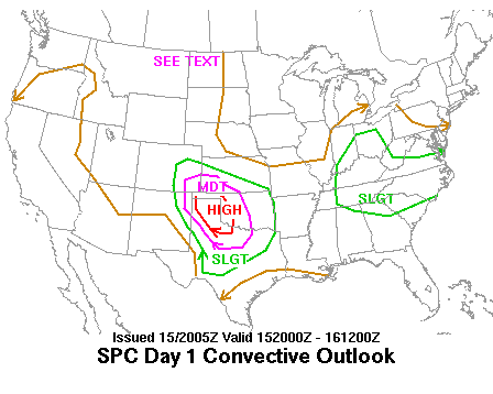
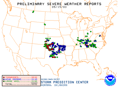
May 15, 2003, existed as a significant severe weather/tornado outbreak across portions of the western high plains and S.Central Great plains of the CONUS. This event is especially notable and historic considering the day fostered the most western high-risk convective outlook to date and produced the greatest number of tornados within the Amarillo/TX panhandle region in a day. Despite the temporal setting of the system in the early 2000s with limited technology, fortunately, with the forecasted high-end nature, substantial documentation and recordings exist, in which the majority of the tornadoes were evenly documented. Within this thread, I will concisely discuss both the meteorological conspectus/synopsis of 5/15/2003 portrayed through synoptic-scale and mesoanalysis levels. I will also provide links to prominent photos/video recordings of the event as well.
Synoptic Scale/Upper Levels
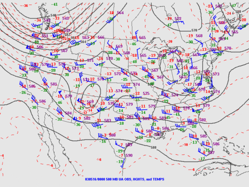
Analogous to many classic high-end setups within the TX panhandle and surrounding areas, the system was defined with an increasingly negative orientated and deepening upper-level trough that progressed slowly toward West TX, with its core bisecting the SW United States. At 00z C.D.T. the upper-level low anchored itself within NM, providing broadened Southwesterly flow nearing 55 knots, cold temperatures aloft up to -13 F, and strong divergent lift promoting rapid vertical velocity and height falls across the warm sector. With increasing height, shear vectors veered gradually to the east which contributed to adequate deep-layer vertical/directional shear.
SFC/Mesoanalysis
Similar to the synoptic/kinematic setup, the thermodynamic/mesoscale environment was also very impressive. At the surface, a strong lee cyclone developed to the west in E. NM; encouraged by upper-level winds intersecting and downsloping the continental divide. This SFC low provided strong warm/moist air advection and backed SE sfc winds across the panhandle. Dewpoints ranged from low to upper 60s, with temperatures in the low 80s promoting Sfc based storm mode, and low cloud bases. A sharp dryline with a pronounced sfc dry slot existed with temperatures well within the 90s and dewpoints in the 30s to the west of dryline. a warm front was planted in the north tx panhandle, connecting to the dryline at the triple point in the northwest TX panhandle. Based on the temperature/dew points in relation to the frigid air aloft, moderate to high instability existed with sfc CAPE and MLCAPE values as high as the upper 3000s j/kg. With the upper-level cold-core paralleling and overlapping the warm sector, mid to low-level lapse rates denoted a very unstable atmosphere with values in excess of 8.0 C/km. Additionally, a weak capping inversion stunted pre-mature convection throughout the day, which only furthered destabilization. Upper-level winds also intersected the sfc focal boundary (dryline) at a wide-angle which assisted in mostly discrete storm mode. A strong meridional LLJ at 850mb aided profound low-level shear with 3km surface-based helicity eclipsing 500 m2/s2.
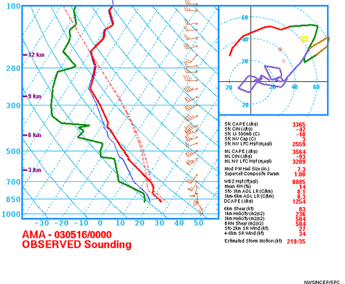
(above) The spatiotemporal Skew-T chart denotes a very unsteady environment with strong wind shear, and gradual veering with height. The Hodograph correlates to the shear vectors, which also shows a very kinematic and dynamic scenario.
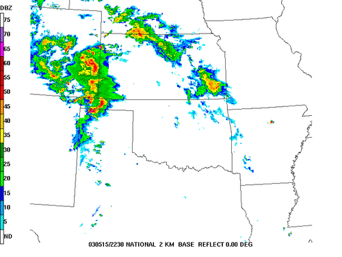
Nearing 00Z convection began to develop rapidly with swift tornadogenesis in the Northwest TX panhandle and W. OK Panhandle
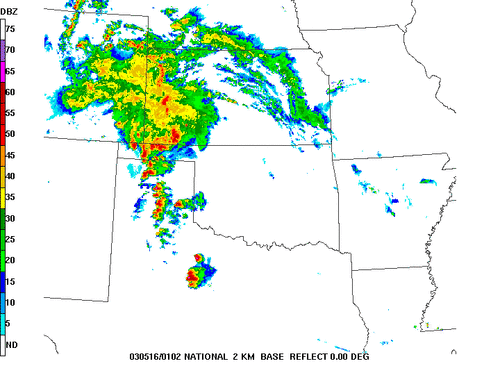
After the first supercells began to move to the north, an additional string of supercells formed across the mid panhandle
Here are some links to videos that showcase the life span of the Stratford, TX tornados


Synoptic Scale/Upper Levels
Analogous to many classic high-end setups within the TX panhandle and surrounding areas, the system was defined with an increasingly negative orientated and deepening upper-level trough that progressed slowly toward West TX, with its core bisecting the SW United States. At 00z C.D.T. the upper-level low anchored itself within NM, providing broadened Southwesterly flow nearing 55 knots, cold temperatures aloft up to -13 F, and strong divergent lift promoting rapid vertical velocity and height falls across the warm sector. With increasing height, shear vectors veered gradually to the east which contributed to adequate deep-layer vertical/directional shear.

SFC/Mesoanalysis
Similar to the synoptic/kinematic setup, the thermodynamic/mesoscale environment was also very impressive. At the surface, a strong lee cyclone developed to the west in E. NM; encouraged by upper-level winds intersecting and downsloping the continental divide. This SFC low provided strong warm/moist air advection and backed SE sfc winds across the panhandle. Dewpoints ranged from low to upper 60s, with temperatures in the low 80s promoting Sfc based storm mode, and low cloud bases. A sharp dryline with a pronounced sfc dry slot existed with temperatures well within the 90s and dewpoints in the 30s to the west of dryline. a warm front was planted in the north tx panhandle, connecting to the dryline at the triple point in the northwest TX panhandle. Based on the temperature/dew points in relation to the frigid air aloft, moderate to high instability existed with sfc CAPE and MLCAPE values as high as the upper 3000s j/kg. With the upper-level cold-core paralleling and overlapping the warm sector, mid to low-level lapse rates denoted a very unstable atmosphere with values in excess of 8.0 C/km. Additionally, a weak capping inversion stunted pre-mature convection throughout the day, which only furthered destabilization. Upper-level winds also intersected the sfc focal boundary (dryline) at a wide-angle which assisted in mostly discrete storm mode. A strong meridional LLJ at 850mb aided profound low-level shear with 3km surface-based helicity eclipsing 500 m2/s2.

(above) The spatiotemporal Skew-T chart denotes a very unsteady environment with strong wind shear, and gradual veering with height. The Hodograph correlates to the shear vectors, which also shows a very kinematic and dynamic scenario.

Nearing 00Z convection began to develop rapidly with swift tornadogenesis in the Northwest TX panhandle and W. OK Panhandle

After the first supercells began to move to the north, an additional string of supercells formed across the mid panhandle
Here are some links to videos that showcase the life span of the Stratford, TX tornados
