Is it really PDS?

Add to what Boris and Matt have said: it takes a psychological toll on people to have to go into "emergency" mode too often. We aren't designed to be in a near-constant state of fight-or-flight. No one is in 'near-constant' warning mode for weather, but the point is that there is a threshold above which is "too much" for being told something along the lines of "run to the basement or die." Not every harmful situation is a true emergency and thus not every potentially harmful situation needs to be treated as one. The SBW paradigm that NWS rolled out a few years ago may have been an attempt to address the graduation of severity of needed reaction.

My as-yet-unspoken allegation in this thread is that some NWS WFOs may have decided to start using PDS Tornado Warnings a little too liberally under the impression that there is a simple linear relationship between intensity of wording and response that will hold for a given population over many years. The conclusion is that "if I issue PDS TW over a 'regular' TW, I'm going to get more response, which is what I - the warning meteorologist - wants." However, I strongly suspect that this attitude will break any seemingly linear relationship between intensity of warning wording and response urgency (if that relationship even still exists).

Once every tornado warning becomes a PDS tornado warning, then PDS tornado warnings cease to carry the weight they once did. Next you'll start seeing increases in Tornado "Emergencies". It nudges up against the notion of the "Red Queen's Race" problem.
Do you think that is personality over policy driven? what one WFO does is different than others depending on leadership locally? or is there a standard to follow, but the guidance doesn't exclusively spell out what is authorized, useful, practical, to the situation, and left up to the team issuing the warnings.
 
The PDS/tornado emergency watch/warning track record has been abysmal post-Greensburg. I am surprised those aren't just nixed altogether by the higher-ups (go back to just straight tornado watches and warnings). Our science/capabilities that would allow for those types of distinctions clearly isn't there yet.

I'm inclined to agree, although to SPC's credit, two of the three EF4 tornadoes this year and one of the two last year were within PDS watches. Of course, we've also seen PDS watches relatively recently where large portions (half or more) of the watch area have been void of tornado reports, let alone significant tornadoes.
 
As the damage criterion is "catastrophic" damage, only violent tornadoes produce those. Is everyone aware that Dr. Patrick Marsh did a study of TOR-E's for his dissertation and found that they verified a measly 12% of the time?! This, by itself, argues that TOR-E's should stop.

We are confusing the heck out of the public with (false) landspouts, three levels of tornado warnings, and TOR-tags to severe thunderstorm warnings.

One of the few advantages of having done this for 50+ years is having a huge amount of interaction with the public which continues today via comments to my blog and elsewhere. Our goal must be to serve the public, not to please ourselves.

The figure at far right is from yesterday. This tornado was called a landspout even though it came from a supercell!

We need to go "back to the future."
 

Attachments

  • Screenshot 2024-06-04 at 9.48.08 AM.png
    Screenshot 2024-06-04 at 9.48.08 AM.png
    588 KB · Views: 13
  • Screenshot 2024-06-04 at 9.48.27 AM.png
    Screenshot 2024-06-04 at 9.48.27 AM.png
    294.3 KB · Views: 8
  • Screenshot 2024-06-04 at 9.49.43 AM.png
    Screenshot 2024-06-04 at 9.49.43 AM.png
    105.7 KB · Views: 8
  • Screenshot 2024-06-04 at 9.54.33 AM.png
    Screenshot 2024-06-04 at 9.54.33 AM.png
    585.1 KB · Views: 13
As the damage criterion is "catastrophic" damage, only violent tornadoes produce those. Is everyone aware that Dr. Patrick Marsh did a study of TOR-E's for his dissertation and found that they verified a measly 12% of the time?! This, by itself, argues that TOR-E's should stop.
That's a really good point, Mike. The fact that tornado emergencies are not verifying statistically better than regular tornado warnings is a big hit against the use of tiered warnings in general.

Boris, I was not aware of that infographic you showed, but it seems to shed some light on why we see PDS tornado warnings in seemingly relatively "benign" scenarios. Perhaps the warning meteorologist is actually obeying some kind of flowchart to decide what kind of warning to issue. That then calls into question the system rather than the idiosyncrasy of the warning meteorologist. Jason, this gets at what you were asking - I have wondered if those are personal decisions (but that are still within the acceptable scope of what kind of product can be issued in the situation).
 
I'm inclined to agree, although to SPC's credit, two of the three EF4 tornadoes this year and one of the two last year were within PDS watches. Of course, we've also seen PDS watches relatively recently where large portions (half or more) of the watch area have been void of tornado reports, let alone significant tornadoes.

We had a PDS in the Delmarva region a year or 2 ago where it was hyped up a few days prior... schools were let out early and some business closed once the watch was issued. Even though the parameters were close to the forecast, a few key pieces fell through and it barely rained... not even any SVR. I've never heard so many people at one time say they weren't gonna listen to future warnings.

Maybe the issuance of a PDS shoud be predicated on the start of actual ongoing SVR. Put out the standard watch with language that indicates the likelihood of an upgrade if the forecast warrants it, then pull the trigger on the upgrade when crap starts hitting the fan. I know watches are meant to be an advanced notice, but the publics opinion on the credibility of these things are to the point most people completely disregard them, so advanced notice isn't heeded anyway.... might as well get the verification stats headed in the right direction.
 
Maybe the issuance of a PDS shoud be predicated on the start of actual ongoing SVR. Put out the standard watch with language that indicates the likelihood of an upgrade if the forecast warrants it, then pull the trigger on the upgrade when crap starts hitting the fan. I know watches are meant to be an advanced notice, but the publics opinion on the credibility of these things are to the point most people completely disregard them, so advanced notice isn't heeded anyway.... might as well get the verification stats headed in the right direction.

Did you know that in 1960, severe and tornado watches were issued hours before they went into effect?

For example, they would issue a watch at 11am to be in effect from 2pm to 10pm. To improve verification, they stopped doing that (I want to say in the 70's, but that might be wrong). Now, watches are often issued after thunderstorms, sometimes severe, are in progress.

On a couple of occasions, I have tried to get verification data from SPC and it is supposedly unavailable. My sense is that watch accuracy has, at best, plateaued in recent years. Tornado warnings are less accurate as the data clearly shows. If I were the NWS, I would be fixing the underlying problems rather than continuing to "slice" warnings into ever smaller bins.
 
i've broken my comments into two posts as they deal with related, but slightly different, topics.

Boris, thanks for the chart. Look at the line across the top. Does anyone see a major issue?Screenshot 2024-06-04 at 11.28.30 AM.png

This guidance essentially guides the NWS meteorologist to issue a tornado report (e.g., a tornado is occurring) rather than a tornado warning (advance notice a tornado is going to occur).

This might explain why lead times have halved in the last dozen years.

What I want to see is better guidance on how to warn of tornadoes. We did a great job from ~2000 to ~2010. What has gone wrong!
 
Mike,

I know from my own past experience, prior to Dual Pol, we used to look at predictive warnings based on 2TVS detection from 2D and 3D correlated shear, essentially sizing up whether or not the alignment was right for vorticity generation. and if it remained over 2 volume scans, we would warn it, with the Caveat of radar indicated. what I don't know is whether this method led to more false alarms or not over time and space.

They still textualize radar indicated on warnings today, but this older method to me seemed more predictive at least. Now the trend seems to maybe be more reliant on the Dual Pol products, NROT, and CC verifying if in fact a tornado is present as opposed to warning the iniital stages to evolution. I've seen several 'radar indicated" Tor warns upgrade to PDS, and it seems like they want to show the trend line to somehow display their accuracy to validate PDS/TORE for the money spent on Dual Pol technology, but if the warning stats are as low as they are in some cases, there's got to be some way of improving it. Like many have said it seems like there is several parts to this equation.

-Personality / WFO site leadership / warning forecaster variance from WFO to WFO.
-what's the clarity on NWS guidance/standards and boundaries on TOR warning issuance, are they the same everywhere?
-public trust/ awareness/ psychology / messaging - how much is too much and is oversaturation even considered at the WFO's
-executive pressures? this happens behind the scenes of course.
 
Hi Jason,

Thanks for your note. Very helpful.

I'm providing some national tornado warning figures which, as far as I know, are the most recent available. The NWS has not met its own warning accuracy targets since 2013 -- that's a decade (right-hand column in the second item I posted). I contend that is a serious issue.

I can't find the latest FAR (I'll post it when I come across it) but here's the thing: all of these "adjustments" have improved the FAR by about 3%. Just 3%! The public can't perceive a three percent reduction in false alarms, but they certainly do perceive when there is a tornado without a warning.

Here's a story from 2023 that illustrates the problem: https://www.star-telegram.com/news/weather-news/article276975443.html There is a lot of rationalizing by the AMA, LBB and BRO NWS MIC's. But, in every case, there were more than sufficient indications are tornado was present or was going to form. In the case of the Matador Tornado, it was being broadcast live on television with no warning in effect!

If the FAR was reduced by, say, 50% then missing some of these tornadoes might be justified because of the increased overall warning accuracy with the better CSI. But, missing significant tornadoes that cause deaths is certainly not worth it for 3%.

Mike
 

Attachments

  • Screenshot 2024-06-04 at 12.31.46 PM.png
    Screenshot 2024-06-04 at 12.31.46 PM.png
    172.5 KB · Views: 3
  • Screenshot 2024-06-04 at 12.32.28 PM.png
    Screenshot 2024-06-04 at 12.32.28 PM.png
    1.5 MB · Views: 2
Mike,

could you expound on what they mean by lead time here. I have seen Leadtime being used in more than one way. Watch Leadtime/Warning Leadtime... so, is it that reference Leadtime to a valid period, Leadtime to formation, or is spatial Leadtime to a location being affected inside the polygon. Just curious.
 
Jason,

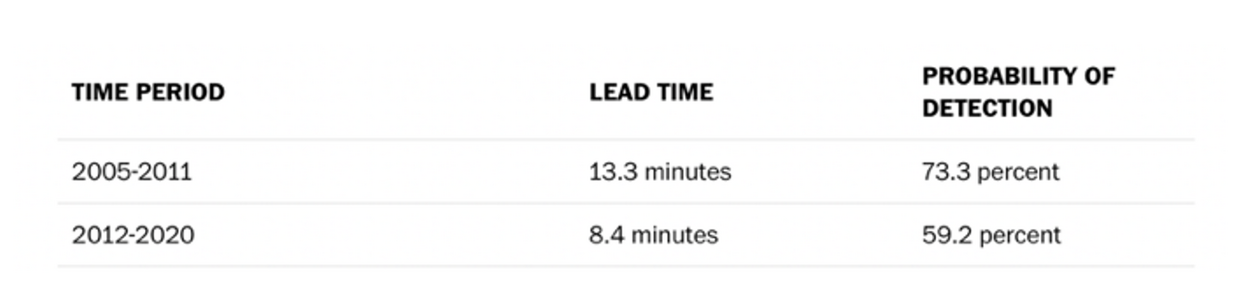
As calculated at that time, TOR lead-time was from when the warning was issued to the first report of the tornado on the ground. The average lead-time was a little more than 13 minutes which, per Kevin Simmons' research, is about perfect (beyond 15 minutes of lead-time, fatalities rise). Now, it is eight minutes.

Here's an opinion on a related topic: dual-polarization has been a bust compared to how it was sold. That is for two reasons:

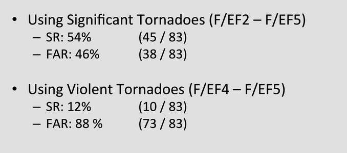
  • There is a temptation to wait until there is a TDS to issue a tornado warning. That temptation didn't exist before. I know that in a least a few occasions, that accounted for a tornado warning delay. Look at Boris' chart (above). Issue an upgraded tornado warning after a TDS appears. At that point, you are issuing a tornado report rather than a warning. The TDS was intended to be a backstop at night but it was never intended to be a primary warning criterion.
  • D-P was sold as making a revolutionary improvement in flash flood warnings because its rainfall calculations were supposed to be much better than single pole. While they probably are better, there are far too many times they are off the mark.

Remember, I wrote a book (published in 2010) full of praise for the NWS. I had no way of knowing that I was publishing at the very height of tornado warning accuracy.

We used to issue tornado warnings well. I believe we need an independent National Disaster Review Board (modeled after the NTSB) to help figure out how we can get at least back to where we were. In the meantime, we need to honestly confront the issue and -- where possible -- go back to the techniques that were so successful 15 years ago.


Addition at 9:38pm Tuesday: In my part of far northeast Wichita, the DP rainfall estimates are terrible this evening. KAAO (14.4 miles NE of KICT WSR-88D) has a DP estimate of 1.04 with the actual 1.20 inches and, it is known that the rain gauge at KAAO tends to read now for some reason.

At my house, we had over an inch and the radar estimated .76 inches.

There was no hail at either location (and, even if there was, DP is supposed to allow for it). It is not at all clear to me these are superior to the estimates in the pre-DP era.
 
Last edited:
This was just now released by the National Hurricane Center. Interestingly, their accuracy went down in 2023, the most recent hurricane season. There were other problems.

You'll recall their performance on Cat 4 Hurricane Ian (the worst storm of 2022, by far, in the U.S.) was awful. They bought the GFS which was completely out to lunch while the UKMET and ECMWF were excellent.

Question: is the profession getting lulled into complacency by the -- highly inferior -- GFS and does this also explain some of issues with tornado forecasts?

I may be offline for a while. A severe thunderstorm watch for Wichita.
 

Attachments

  • Screenshot 2024-06-04 at 2.31.03 PM.png
    Screenshot 2024-06-04 at 2.31.03 PM.png
    684.4 KB · Views: 0
I will add though, the large picture, as to how weather in general has been treated in recent decades with so much hype and exaggeration, is not helping the situation. Events not nearly as serious as a real-time tornado situation often are treated as "the worst ever," "unprecedented," and "extreme." For instance, yes, a snowstorm is impactful and causes disruption, but most are very manageable and not something that is going to require absolute measures in terms of impact. Or a typical hot or cold outbreak in a given region. When did we suddenly become so vulnerable to hot wx in the summer and cold wx in the winter? Like we can't handle temps 90-95 F when the average temp across nearly 50% of the Lower 48 has average high of 90 F or higher in the middle of summer? There is all too often a lack of context and perspective. And some of the public has grown tired of this endless hype and are tuning-out weather alerts and warnings completely. Again, not something we can just ignore!

Love this. Couldn’t agree more. Adding to the lack of context is the general public’s inability to understand probabilities and risk.


Once every tornado warning becomes a PDS tornado warning, then PDS tornado warnings cease to carry the weight they once did.

Indeed. Analogous to something that can be measured mathematically, it’s impossible for *everything* to be “above average,” because then that is just the average!
 
Not every harmful situation is a true emergency and thus not every potentially harmful situation needs to be treated as one.

Great point and in my view does support at least two types of tornado warnings (but I agree three is too many). I do think there’s a difference between a typical tornado warning (may or may not be a tornado on the ground; may or may not hit a town in the middle of nowhere; message is, no imminent danger, but be situationally aware) and a confirmed, large tornado bearing down on a town or city (i.e., clear and present danger).
 
Back
Top