• While Stormtrack has discontinued its hosting of SpotterNetwork support on the forums, keep in mind that support for SpotterNetwork issues is available by emailing [email protected].

Hurricane Melissa October 2025

Joined
May 21, 2011
Messages
438
Location
North-central Nebraska
Image 1.jpg
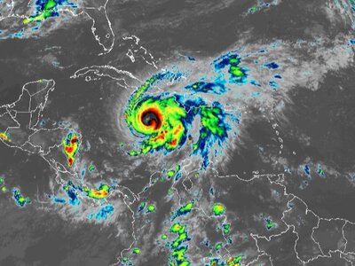
While the US coastline experiences its biggest lull in hurricane landfalls in a decade, Hurricane Melissa heads towards eastern Jamaica, poised to create a multitude of problems there later this weekend & beyond. Infrared image from 22:20Z, GOES 19 Band 13, shows an intensified system that will soon grow into a major hurricane, albeit a slow-moving one for the next few days.
 
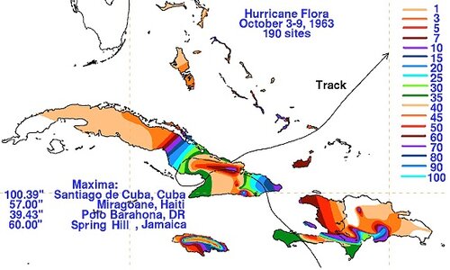
Sixty-two years ago, another major Hurricane lingered in the Caribbean in October (NCEP).
______________________________________________________________________________
Image 2.jpg
_______________________________________________________________________________
1963's Hurricane Flora produced benchmark rains along a slow-moving & loopy path.
Cuba, for example, saw 100 + inches in spots. The storm also killed over 7000 people.
 
I'm amazed at how many chasers with little or no experience are pursuing Hurricane Melissa -- per social media. Love the quest for adventure, but trying to tackle a Cat-5 on a tiny island with very poor infrastructure, including no elevated coastal highways for last minute repositioning, is a recipe for disaster. I've also been told by residents in Jamaica that many of the coastal buildings are no "up to code."
 
...a recipe for disaster.
I fully agree. I've got a friend down there that I've lost touch with over the years, and I'm certainly concerned.
The coffee plantations that got back up to speed after the last hurricanes will have a lot of work to do afterwards...
...as will other agricultural concerns, too.
Image 1.jpg
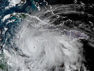
The 21:40Z GeoColor composite image shows ~ 10 nautical-mile-wide eye.
I know I wouldn't want to be in Jamaica (or SE Cuba) later tonight/tomorrow.
 
There is one chaser who is in a locked down hotel and keeps asking for advice on social media. I've replied a few times. The actual hurricane is dangerous, but the aftermath could be even worse. After Ivan in 2004, emergency workers (and others) were being robbed at gun point and there was wide spread looting, some with firearms. The few times I've been in scary, post-storm situations, I've always removed the camera data cards right after the storm and placed them in a safe hiding place in the event I'm robbed of my cameras. Getting around afterwards would be a nightmare.
 
Despite the intense landfall, only about 1/4 of Jamaica appears to have had hurricane conditions. The max sustained winds so far at Kingston (MKJP) has only been 41 kt,
but almost the entire time since Melissa started to impact Jamaica, the winds have been below minimal TS strength.

Some may find this difficult to accept, but I would argue that Melissa, despite being very intense, was so small and compact for its core, it ended *saving* much of Jamaica from very high impact overall. Compare to Hurricane Gilbert in Sep 1988. It made landfall as a 115 kt Cat 4 and cut directly down the entire length of the island E to W, so *all* of the island had Cat 3/4 conditions, and devastation everywhere. That's not the case of Melissa.

Manley Intl airport in Kingston has come out largely unscathed, so airborne relief can begin almost immediately.

But good luck finding any of the MSM stating the above. It's all bad, bad, bad!
Listening to the MSM and looking on social media, you'd think the world had ended.
 

Most Intense Atlantic Hurricanes by Central Pressure

Name Date Pressure (mb)
Wilma Oct 2005 882
Gilbert Sep 1988 888
"Labor Day" Sep 1935 892
Melissa Oct 2025 892
Rita Sep 2005 895
Milton Oct 2024 895
Allen Aug 1980 899
Camille Aug 1969 900
Katrina Aug 2005 902
Mitch Oct 1998 905
Dean Aug 2007 905
Maria Sep 2017 908
"Cuba" Oct 1924 910
Ivan Sep 2004 910
Dorian Sep 2019 910
Janet Oct 1955 914
Hattie Oct 1961 914
Irma Sep 2017 914
"Camaguey" Nov 1932 915 ***
Isabel Sep 2003 915 *
Erin Aug 2025 915
Opal Oct 1995 916 **
Iota Nov 2020 917 **
"Great Atlantic" Sep 1944 918
Hugo Sep 1989 918
Esther Sep 1961 919
Gloria Sep 1985 919 **
Michael Oct 2018 919
"Great Abaco" Sep 1932 921
Beulah Sep 1967 921
Floyd Sep 1999 921 **
Andrew Aug 1992 922
Eta Nov 2020 922 **

* estimated, lowest measured 920
** not category 5
*** not measured in ey
e

These readings are at any time in the hurricane's existence. Most
listed were not this strong at a landfall.

This list is not 100% accurate, esp. for storms prior to the 1970s.
Most of these on the list were at least as low as this for pressure,
and the farther you go back, the more likely the underestimate.

Also, the ephemeral nature of category 5 hurricanes (the avg
duration at this strength is only 22 hr) historically has made it
difficult to catch/measure any storm at its peak intensity, which is
a problem even today, esp. when a storm is far at sea. It is only
in recent decades have the observational platforms and technology
allowed us to better detect what actually occurs.

And this will clear up the hysteria among so many on social
media that Melissa is "unprecedented" or the "strongest ever."
It is tied for the most intense landfall, and in the western
hemisphere only!
 
Sixty-two years ago, another major Hurricane lingered in the Caribbean in October (NCEP).
______________________________________________________________________________
View attachment 28342
_______________________________________________________________________________
1963's Hurricane Flora produced benchmark rains along a slow-moving & loopy path.
Cuba, for example, saw 100 + inches in spots. The storm also killed over 7000 people.

A Nov 1909 TS and its PRE (predecessor rain event) dumped 135" in a 8-day period at Silver Hill, Jamaica for the most rainfall from TC-associated rainfall in the Western Hemisphere.
 
Boris, I think you’re right. I know it takes time to get reports and imagery from ground zero, but the initial reports from areas farther east of the eyewall don’t show massive destruction like you’d expect from a Cat 4/5. Michael was like that, winds in the outer core of the storm were barely TS strength. When the eyewall arrived in Panama City, winds ramped up very fast. There was very little significant damage until the eyewall started moving into the city.
 
The RMW (radius of max wind) for Melissa reminds me of the Labor Day Hurricane in Sep 1935. It crossed the central FL Keys as the same pressure as Melissa (892 mb), and yet Key West and the Upper Keys barely got minimal gale-force winds. Melissa's RMW seems to e somewhat larger than the 1935 hurricane.

In the re-analysis of the 1935 hurricane, it was revised from 140 to 160 kt, but it said it easily could have been significantly higher given its tiny RMW, pressure gradient, rapid intensification rate at the time of landfall, and its environment it was in, 175 kt sustained winds were not out of question. Given what we saw in Patricia in 2015 which peaked at 185 kt, this does not seem unreasonable.

The inner cores of very intense hurricanes are strange beasts and category 5 status does not last long (22 hr on avg in the Atlantic), and we have limited good, in situ data within such phenomena, so still are finding out new things.
 
I’m no expert, but I would think the more intense the hurricane, the smaller it generally is, just because the circulation is so tight - so there’s some inherent modulation to how much damage they can cause. Which is not to say it’s not still catastrophic - Hurricane Andrew is just one example. After all, tornados are rarely more than a mile or two wide, but still cause incredible damage.
 
Despite the intense landfall, only about 1/4 of Jamaica appears to have had hurricane conditions. The max sustained winds so far at Kingston (MKJP) has only been 41 kt,
but almost the entire time since Melissa started to impact Jamaica, the winds have been below minimal TS strength.

Some may find this difficult to accept, but I would argue that Melissa, despite being very intense, was so small and compact for its core, it ended *saving* much of Jamaica from very high impact overall. Compare to Hurricane Gilbert in Sep 1988. It made landfall as a 115 kt Cat 4 and cut directly down the entire length of the island E to W, so *all* of the island had Cat 3/4 conditions, and devastation everywhere. That's not the case of Melissa.

Manley Intl airport in Kingston has come out largely unscathed, so airborne relief can begin almost immediately.

But good luck finding any of the MSM stating the above. It's all bad, bad, bad!
Listening to the MSM and looking on social media, you'd think the world had ended.


I was thinking the same thing but didn’t want to post such comments on social media. The actual intense eyewall appeared to be very small — maybe 3 to 5 miles wide by satellite estimates — though I could be wrong. Looking at Google’s landscape mapping, the eyewall seems to have passed mostly over sparsely populated areas. That’s not to say people in those regions escaped the insanity, but I sincerely hope they did.

I was very uncomfortable on Sunday after deciding not to chase Melissa — especially from a historical journalism standpoint, and even more so once it became a daytime landfalling storm. But my instincts were right: it did move west, struck a region with little or no infrastructure (unlike Kingston), and the only viable option would have been to deploy remotes. The problem, of course, would be retrieving those remotes later — and the risk of theft. There are no substantial coastal highways like we have in the US and most access to the beach areas is via inland roads running N/S.

I’m also concerned that we haven’t heard back from Max or Josh, who were last reported near the eyewall. They’re both very experienced survivors, but I’ll feel a big sense of relief once they check in.
 
Back
Top