• While Stormtrack has discontinued its hosting of SpotterNetwork support on the forums, keep in mind that support for SpotterNetwork issues is available by emailing [email protected].

HP/other storms a risk for beginners

Joined
Mar 27, 2014
Messages
50
Location
Kansas City Mo
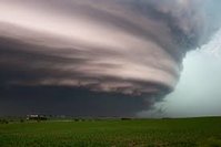
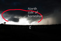
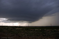
Looking back over my own learning curve, I want to address something that I feel could pose a threat to beginners, with little or no field experience. Without experience, I think it is too easy to accept hard rules about storm structure. For example text book examples of supercell storms, tell us the rain exists in the FFD, while the tornado exists under the rain free base, near the RFD. In the field however storms can be messy and have characteristics unique to themselves. HP storms can have RFDs full of rain that wraps the tornado and hides it. There was a time , when looking at pictures of HP storms I would mistake the RFD and mesocyclone area of the storm as the FFD, simply because there was a rain shaft below. For example, at one time I would have mistaken the picture attached to be of the FFD, and expected the tornadic region to be off screen somewhere to the left, south or behind of the feature pictured. This is of course wrong and in the field this mistake could lead a beginner into bad positioning and result in missing a tornado or worse finding one accidently.
While I never chased an HP storm as a beginner, during one of my first chases on a tornado warned storm I was completely lost because the rotation was on the leading edge of a QLCS. At the time I didn't even know what a QLCS was, but I "knew" tornadoes and rotation occur on the back of storms. Lack of knowledge of storm modes alternative to classic super cells, along with blind acceptance of "rules" left me very confused and with no situational awareness at the time. My advice to other beginners is to learn about all severe storm modes, chase with someone with some experience, and give dangerous storms lots of space at least until you are really sure of what you are looking at.
 

Attachments

  • HP storm.jpg
    HP storm.jpg
    3.9 KB · Views: 265
Personally speaking, I hate chasing HP's. Lots of times, I'll actually break off of an HP in hopes of finding something more chaseable. As been said, they are messy, and very hard to chase unless you get right in the teeth of the beast. I like backing away from a storm and getting the structure shots more than being in the notch of the storm. That being said, bring me a well structured LP and I'll be happy every time!!
 
I would take it with a grain of salt. There are instances of people who tracked storms via radar for years before they ever chased one in the field for the first time. I know when I started chasing, I'd been reading everything I could get my hands on about storms for the previous 13 years, so I had more than just basic knowledge. I also knew the area and knew the local tendencies of various weather and knew the roads very well as well. But, my family's close call in 93 made me stay very cautious, something that influences my chasing style to this day. That was actually a very HP, rain wrapped F4. Not an experience I care to go through again.

That being said, I don't like playing with HP. If I can't see, I don't like it. That's also why I'm reluctant to chase at night. Just a case of previous experiences influencing future choices.
 
It won't let me edit my post but I'd like to clarify. The scenario I described is probably the exception. Most new chasers are probably like you described yourself as being. But my point is we can't assume the knowledge level of every new chaser. For all we know, there may be some aspects that they already have down pat.

It is certainly easier to network and get experience with other chasers than when I started though. I wasn't on Facebook or Twitter when I started, and I didn't know anything about StormTrack or any way to network with other chasers like what's available now. It was a steep learning curve, but it was doable
 
Drew , your right that we cant know everyone's knowledge, Im just encouraging people to work within there own level. For example while 13 years of radar tracking is great, I would encourage that person to use caution until they have actual field experience, actually seeing the storm for themselves and learning to navigate around the storm safely with/or without radar.
 
I can agree with that. Even I use a good deal more caution than usual when I'm chasing in an area that I'm not very familiar with. I don't know the roads and I don't know the nuances with regards to weather tendencies in areas away from home. The way I chase close to home and the way I chase away from home are completely different, if that makes any sense.
 
There's consistent structure on LP's, classics, and HP's that you can use to get your bearings on a storm and the tornado's position. The most telling structure for me is the horseshoe shaped updraft base that wraps around the RFD/hook. The shape of that horseshoe is often present whether the RFD is wet or dry. If I have a visual on that, I know where I am relative to where the tornado is most likely to be, even if it is completely rain wrapped.

The cool thing is that this even works on QLCS tornadoes and embedded supercells as that kink in the line still makes that characteristic horeshoe shape.

Here's a few slides I put together for a spotter talk to visualize this:

The orange shape represents the area of the horseshoe updraft base, relative to the hook echo and tornado:
full


Looking north at a classic supercell producing a violent tornado:
full


Classic supercell with developing tornado and no visible wall cloud:
full


Inferring the tornado's most likely location on an HP looking east:
full


Inferring the tornado's most likely location on an HP looking north:
full
 
Last edited:
The most telling structure for me is the horseshoe shaped updraft base that wraps around the RFD/hook. The shape of that horseshoe is often present whether the RFD is wet or dry. If I have a visual on that, I know where I am relative to where the tornado is most likely to be, even if it is completely rain wrapped.

I remember you talking about this on a FB post (I believe) a year or so ago, and I've never forgotten that. Those pics really tell the story of where the TOR is or is going to develop.
 
Great pics Skip. I've noticed tornados can develop both in the horseshoe (as in your first and third picture) and also to the north of the horseshoe or on the north edge of the horseshoe (as in your second picture). I wonder if this position of the tornado effects its interactions with the both the FFD and the RFD? I suspect that a tornado within the hook would be effected by the RFD more than anything else as it would be more cut off from the FFD. While a tornado on the north edge may have more access to the FFD. I have no real clue as to what the effects of all that would be, just pondering on it. Have you (or anyone) been able to note this difference, and/or any general differences in the tornados size, shape, path or strength with respect to these two different areas?
 
A labeled view looking north at the June 17, 2010 Conger, MN EF4 with satellite.

[file]Satellite Aggregation|none[/file]

The main/significant tornado circulation in the supercell is almost entirely fed by the RFD. I think you may be referring to the tornadoes that sometimes form on the FFD gust front near and north of the tornado cyclone/wall cloud, often under the thick inflow band that's feeding into the tornado cyclone. There's vorticity on the FFD (and RFD) gust front and if it and the updraft above it are sufficiently strong, you can get satellite tornadoes off of these circulations. They are typically pulled into the main circulation and the vorticity is aggregated into the main tornado, adding to its strength. In fact, that may be how most tornadoes form or at least a significant contributor to the vorticity of most tornadoes: aggregation of these smaller circulations that are being pulled in from the RFD and FFD gust fronts. I imagine there may be instances where the main tornado is missing or hasn't developed yet and vorticity on these gust fronts is still getting stretched into tornadoes.
 
I agree it can all be confusing for someone first learning storm structure. Growing up in South Arkansas, I rarely ever saw structure. In fact, I didn't really have a clue storms could be so well structured. My thinking early on was all that rain had to be associated with the main downdraft core of the storm not that that was a cage that might house a bear. That of course changed when I actually started chasing and could match up radar with what I was seeing in the field. Also, I too remember Skips facebook post concerning this about an event last year, and it was an excellent point.... how chasers might be focused on a satellite and distracted from the large tornado behind that rain. One of my scariest moments was a situation such as this exactly. I was watching a satellite forming right back in the inflow notch, and wanting to stay until the last minute I was almost caught in the heavy rain and wind of the rfd. Slowed by this I would then be in danger of being in the path of the possible right moving tornado lurking behind.
 
@Austin Jones In the "old days" we used to call this particular area the UDI area: the Updraft Downdraft Interface area. As the name suggests and as Skip has mentioned, this area has a ton of vorticity and is located *somewhat* on the northern/north side of the horseshoe. As this area gets "pinched" from the RFD the vorticity increases - often times manifesting itself very near the low level inflow deck. While my editing skills are not as superb as Skips above, I have attached a few pictures to reflect.

As outlined in the 5-2009 tornado pic - the UDI area can be seen on the "northern" side of the RFD. At this "intersection" the FFD is present and visible to the north and east, the RFD is present and visible as the horseshoe cut (clear air) back to the west and the Updraft just to the right of center (UDI area) It should be noted that this was a classic high precipitation supercell.

The above mentioned horseshoe and associated RFD (dry) can be clearly seen in the attached Corn Oklahoma 2008 picture.
Sometimes, this particular area is not as well defined as we would like depending on the intercept position and or direction of travel in relation to the hook. For example, if the view is to the south from the north or even west to east, the UDI area and associated horseshoe *may not* be visible at all - this can be seen in the attached video from the 5-3-03 Haskel, TX tornado event. We approached this supercell from the north, then west to east, slicing the hook. In this particular situation the horseshoe was obviously not visible nor was the UDI area until we positioned ourselves in the "bears cage", and ultimately very near the tornado cyclone. It should be noted that hook slicing should probably not attempted until much experience is gained - this type of intercept/documentation can ultimately lead you directly into the path of the tornado.


Many of these features simply cannot be seen just by viewing radar alone. Skip has made some wonderful video detailing different approaches to the tornado with respects to maintaining your safety. I would highly encourage those interested to check out those videos as well.
 

Attachments

  • 5-2009 oklahoma tornado.jpg
    5-2009 oklahoma tornado.jpg
    78.6 KB · Views: 245
  • Corn Oklahoma supercell 2008.jpg
    Corn Oklahoma supercell 2008.jpg
    66.3 KB · Views: 232
Back
Top