Garmin GPSMAP 376C

Joined
Dec 24, 2004
Messages
126
Location
Southern Tip of Illinois
Been shopping around for the past few months, trying to decide on a viable mobile weather setup. Have lucked into this little contraption:

http://www.google.com/search?sourceid=navc...n&q=gpsmap+376c

Was trying to wonder if 850 bucks would be worth it. (Also have to get the Mapsource AutoKit for around $200)

Have already spec'd out a laptop and wx worx. Looks to run me up into the $2300-2500 ballpark. (if im going to by a new comp, need to by an upper-end)

Just wondering if anyone has had a chance to play with this yet

Appreciate any suggestions/replies...

Thanks!

Nick
[/b]

there are a couple threads already on here about this contraption. i went to Cabelas to touch and feel the unit before I invested in WX Worx.. My opinion is for me anyways i need a larger screen.To zoom in and out on cities and the storms etc.. is something youll find yourself doing alot of.

George Flickenger seems to have been the Guinea Pig on this one. He says he likes it.. i think after a feww chases i would like to hear from him again on this product..

i would really like to see this unit wiht maybe at least a 6" screen or something larger..

Fred
 
Ill be eager to see your report. I was wondering if this can be hooked to a laptop for a larger screen and if one already has weather WX WORX if it can be converted over to this unit. I also would like to know if it would work wih APRS.

I have been wanting to upgrade my GPS to color and this thing ca even be used as a depth and fish finder which Ive also wanted to upgrade since it has been about 16 years since ive added anything up to date to my boat.

This thing would be used for multiple application as far as my situation goes. Not only chasing but for travel and fishing.
 
My Garmin 376c Product Review:


Good :

-lower cost compared to WxWorx: about $800 "street price"
-can get XM weather data (fisherman package) for only $30 a month.
-small, lightweight, easily portable for non-storm chasing applications.
-easy operation: no software issues, just turn it on, and radar data arrives about every 5 min.
-can run 4-10 hours on battery charge or 15 watts of plug in current.
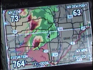
-shows time stamp of data-- see below, data "-6 min" old
-no laptop required
-display brighter than my laptop
-customizable settings weather data plot settings
-non smoothed composite animated or composite still image
-underlay warnings or show warnings only
-easy zoom in/out
-surface autoplots: drylines, Lows, cold fronts and they appear reasonably accurate.
-lightning data available
-IR sat
-easy to use/ config GPS features
-can be set to display currents obs from nearest NWS metar site.
-unit is waterproof, appears very well built.
-touch pad is lighted at night.
-the unit "beeps" and displays warning if you're in the county when its issued.

cons:

-fewer weather features than WxWorx: No shear markers, echo tops, detailed storm tracks, storm attributes, upper level features
-surface winds and pressure analysis nearly useless: only updates about twice a day.
-screen much smaller than a laptop.
-will not accept external display monitor (such as laptop)
-included basemap is limited: only has major roads/highways. $200 auto navigation package required for street level maps
-difficult to access current obs from other parts of the country-- you just get the nearest location.
-no velocity data, composite reflectivity only.
-no visible sat data


Bottomline:

Has met, fullfilled and exceeded expectations so far. Would purchase again. I've also since purchased the auto navigation package for street level data. If you want to avoid a high end laptop for the purpose of running WxWorx, need a "portable radar" that's easy to use and doesn't take up much room, this is for you.

You don't get WxWorx features such as shear markers or storm tracks-- but that's for my eyes to decipher in the field anyway.
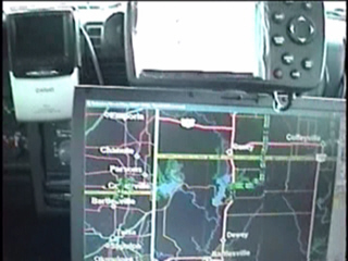

Here's my setup:

The Garmin is on top with my laptop running Delorme street atlas below.
garmin_b.jpg


Garmin close up (video still capture)
garmin_a.jpg
 
George,

I'm still curious about the extremes of zoom in/out--will it go out far enough to cover a state or region? I assume that zoom in will get down to street level.

Thanks.
 
cons:

-included basemap is limited: only has major roads/highways. $200 auto navigation package required for street level maps


I was curious as to your street level maps on the unit. I too have the unit and it only comes with a 128mb (?) Garmin data card - very limiting. Is there another way to get this more detail onto the unit with the City Select CD's?

I've ordered the 512mb data card to get more street level detail but have since been eyeing the 7200 which has a bigger display (better WX resolution?) and accepts the SD cards (of which I have many).

I was able to splice off data to use the GPS NMEA data for GRLevel3. Next will be the APRS splice.
 
Auto Navigation Package for Garmin 376c review:

the package includes a 128MB data card which can hold several states worth of maps. My 128mb card holds all of: OK, KS, NE and north TX, west AR, west MO and west IA.

Good:

-typical of most GPS software, all roads whether dirt or paved are displayed.
-street names appear when zoomed in tight.
-type in an address, and you can plot a map to its location.
-street level mapping appears when you zoom down and lower to the "0.3" resolution setting, which means you've zoomed in to a 2-3 square mile area.
-you can zoom down as much as you want, basically down to a few feet.


Cons:

-street level data hard to see
-zooming into street level requires lots of button pushing, and you may lose the view of the storms.
-all roads, regardless of pavement type: dirt, gravel or highway, appear as a "black line". Dirt roads and state highways look the same.


Bottomline, I'm not using the street level mapping much when I'm chasing. I have an old laptop which I use to run Delorme Street Atlas, and will continue to do so. In my truck I've placed the Garmin unit as a radar display over the laptop as pictured above in this thread, and together they work well for those purposes.

Any other questions?

I would prefer not to use the Garmin alone for street level mapping due to screen size. The screen size is not a factor for me when showing precip, but roads are only a few pixels thick....for what's it worth, I still have an extra Garmin unit for sale in the Marketplace section, though I'll likely stick it on eBay later this week.
 
quote=George Flickinger

Any other questions?


Still wondereing what max range is when fully zoomed out--will it cover a state or region or is it localized?

Thanks for the details.
 
The unit provides 28 ( I think) levels of zoom. You can zoom out to show all the USA or zoom it to one pixel (about 1kmx1km) of precip.

Of course when zoomed all the way to show the 48 states, you can't decipher the precip very well. Time permitting, I'll take some pics this weekend.

George
 
Back
Top