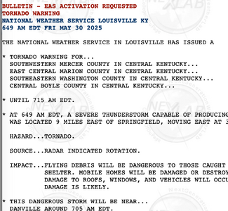
I'm sorry to report there's been another fatal, poorly-warned tornado. It was in Kentucky this morning.
There is confusion this morning as the NWS in Louisville (which did the damage survey) said it completed the survey of the fatal tornado's p...

www.mikesmithenterprisesblog.com
I was unaware of this KY event, and am saddened by the loss of life. However, it reminded me of a similar situation a few years ago (I do not recall the date) where three isolated supercells developed in a N-S orientation from SW KS to the TX Panhandle in the summer after the usual "dryline" tornado season, all within an existing Severe Thunderstorm Watch (STW) box. As I recall, although the VWP was weak in terms of speed and shear and low-level moisture was marginal for thunderstorm development that afternoon, 500mb temps were quite cold for that time of year, so the DDC NWSFO issued a STW for large hail and damaging straight-line winds as the primary hazards. The southernmost of these three supercells "blew up" right over Perryton, TX, and within literally minutes produced a very large, destructive tornado right over that town. It all happened so fast that there was barely enough time for either the DDC or AMA NWS offices to issue a Tornado Warning, despite radar indication. The tornado was already OG and doing damage.
The key takeaway from this event (and others like it) lies in better education of the public. The NWS needs to do a better job, especially in tornado-prone regions, of making the pubic understand that when a STW box is issued, tornadoes can and do occur, sometimes suddenly, within and near the STW area. If a STW (rather than a Tornado Watch) is issued for your area, always assume that a tornado is possible, no mattter what season of the year.
Bottom line: The NWS needs to do a better job of messaging, along with their primary duties of issuing watches and warning to, the public, and the public needs to do its part by taking all watches and warnings seriously and preparing for the worst case, even if less-likely or unexpected to occur. It is a "two-way street," so to speak, between the NWS and the public...so not all the blame can or should be placed on the NWS in every case when situations like this occur. BTW, the SPC already does an excellent job in their Convective Outlooks and Meso Discussions using language to the effect "all hazards are possible, including a strong tornado." The local NWS offices should always convey that same sense of urgency when they issue their local watches, and in the case of issuing a tornado warning,
before a radar indication (debris ball) is confirmed with a visual siting of a tornado.


![WSJ Article About FEMA [06-03-2025].jpg](/data/attachments/44/44575-a8e6b1594112a2ba3593d333d6a0ee4b.jpg?hash=MNZRrsRNQn)