• While Stormtrack has discontinued its hosting of SpotterNetwork support on the forums, keep in mind that support for SpotterNetwork issues is available by emailing [email protected].

Fall..... otherwise known as 2nd season!

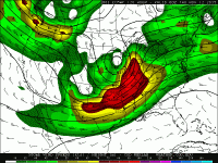
The system progged for Wednesday would be looking downright dangerous right now if not for the forecast marginal CAPE values.

e50d8b5eb08acbff029bff3df4cc1979.gif

That begs the questions...

1.) Is this a lapse rate thing? Moisture return looks plenty adequate.
2.) Is that, in turn, an ENSO thing?
 
Last edited:
I couldn't get out to chase today, but it looked pretty intense. I got to play recliner jockey and watch a couple of tornados on TVN Weather. Thanks to everyone who live streams their video. I know it takes away from your enjoyment, but is invaluable to those of us who can't be on the storm. Thank you
 
There were 2 supercells in that area, one following another. Both tornadoes passed a couple miles south of pampa but not without doing a good deal of damage. :(
Yeah, I heard that there was a gas leak and chemical spill. I really hope no one was killed...
Also, did anyone else notice how similar yesterday's Pampa tornado looked to the 4/14/2012 Lyons-Salina tornado?
 
Damage reports and descriptors are coming in...several fatalities unfortunately :(
The Clarksdale-Holly Springs tornado was an absolute monster. It had a 100+ mile path, was nearly a mile wide at times and was on the ground for over 2 hours.
 
Last edited:
Back
Top