Here is the survey report I wrote for the NWS. I conducted the ground survey with Patrick Burke, WFO OUN. Locations and times were corroborated via numerous sources, including chaser video and photography coordinated with UTC time codes (mine, Aaron Kennedy, etc.) as well as live and recorded local television coverage (including chopper video). I also tested out the new Enhanced Fujita scale on this event.
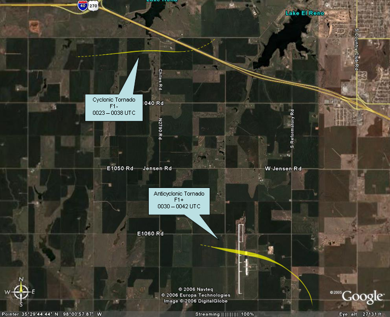
Tornado #1: Cyclonic. Confirmed ground circulation begins at 0023 UTC (25 Apr 2006). It traveled slowly, and mainly through open farm land. It hit a small grove of trees just SW of Elm and Chiles Rd around 0030-0031 (near KFOR reporter David Payne). This is the only observed damage we could find, other than a possible path through the vegetation (grass/wheat) just to the west of those trees about 1/2 west of the road. Local farmer says tornado also passed through some freshly dug up soil, just south of household on the SE corner of that intersection (see slight jog south in path). The main condensation appeared to dissipate around 0032, but "dental floss" rope observed as late as 0038 UTC. Location of the final part of the tornado is unknown, hence the dashed lines. We did find two pieces of "tin" where that path may have crossed Elm east of I-40.
Duration 15 minutes (0023-0038 UTC). Max surveyed width, 30-50 meters.
Applying Enhanced Fujita scale to a damage indicator (DI) of Hardwood Trees, large limbs 6-12" diameter are broken (between DOD2 and DOD3). This is on the border of EF0 and EF1 damage in the 74-94 mph range. Could safely say it had low EF1 winds based on the David Payne video (about 90-95 mph).
Rated tornado low F1 or EF1.
Tornado #2: Anticyclonic. I witnessed first debris at 0031 UTC, but may have been there 1-2 minutes earlier, so I'm going for a start time of 0030 UTC and end time of 0039 UTC. Last part of damage path estimated from KFOR video. Chopper video used to help with path before and after it hit airport. Damage at hangar was to two large metal building systems that were constructed mainly from tin sheet metal panel walls on rigid metal frame. The damage was confined to only the metal panel walls and metal seam roof, with no observed damage to rigid metal frame. Some interior "walls" were damaged, but these were not be part of the rigid load-bearing construction, and hanging from the rigid frame and not anchored to the foundation. Several aircraft were also damaged inside the hangars. Some evidence of anticyclonic swirls in sprayed aircraft oil. Most of the dust from from surrounding ground which had just been turned over due to the new construction, as well as some dry farm fields adjacent to the hangars.
Duration 9 minutes (0030-0039 UTC). Max surveyed width of 200 meters.
Applying Enhanced Fujita scale to a damage indicator (DI) of Metal Building Systems, metal walls and roof panels pulled from building (DOD3). This is EF1 damage of 95 mph. Will slightly bump it to about 100-105mph due to some of the interior non-load bearing walls damaged.
Rated tornado strong F1 or EF1.
This is an illustration of the survey is found
here: