EF-3 Tornado Hits Chicago Suburbs

John Farley

Supporter
Joined
Apr 1, 2004
Messages
1,895
Location
Pagosa Springs, CO
Strange that this tornado is not listed on SPC storm reports. It shows only the weaker Plainfield tornado that is noted near the end of the article.
I believe those reports are obtained from LSR products put out by the NWS Forecast Offices (in this case, Chicago ... LOT). I took a look at the LOT recently issued LSRs and Plainfield is the only one I could find ... and that one was issued yesterday. I am guessing that an updated LSR for the event will come out when they finish the survey (not uncommon for a PNS and LSR to be issued as a result of a survey).
 
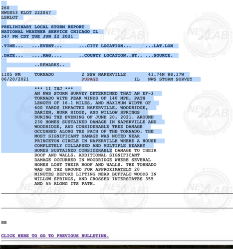
Screen Shot 2021-06-22 at 5.24.39 PM.png

Here is the LSR for the event. Some offices wait until they are finished with the survey before issuing one. The tornado that came close to my home-town Friday night, while it was known already it was likely a tornado, NWS held off on issuing an LSR until the survey was completed. I'm guessing it was the same deal here.
 
Am I interpreting Jon Davies‘ post correctly - the parent supercell was enhanced by an outflow boundary that was created by the line of storms the supercell itself was embedded in? How can that happen, wouldn’t the outflow boundary be advancing too rapidly while the line of storms was still progressing, not to mention the air behind it wouldn’t have the opportunity to modify/recover?
 
Am I interpreting Jon Davies‘ post correctly - the parent supercell was enhanced by an outflow boundary that was created by the line of storms the supercell itself was embedded in? How can that happen, wouldn’t the outflow boundary be advancing too rapidly while the line of storms was still progressing, not to mention the air behind it wouldn’t have the opportunity to modify/recover?

I am not sure that is the correct interpretation - perhaps the outflow boundary was already there from earlier storms, and then the line of storms that produced the tornado encountered it? I don't know enough about the sequence of events that night to say for sure, but that would seem like a possibility.
 
@John Farley That would make sense, but the way Davies wrote it sounds like it was directly associated with the parent line of storms:

“A brief look at the local setting and environment over northern IL on Sunday evening June 20th showed a quasi-stationary outflow boundary associated with the east-northeast to west-southwest line of storms across the Naperville-Chicago area:”

Unless, as you suggest, he was talking about an earlier line of storms...

I left the same question as a comment on his blog, will see if he responds/clarifies.
 
Davies' language is vague, so it is hard to tell if James' interpretation is correct or not.

However, I think there have been past cases of a storm ingesting outflow associated with its own convective system and eventually producing a tornado. See 25 May 2015, when Moore, OK was hit by an EF2 tornado from a supercell that appeared to ingest its own outflow boundary. Since it happened so close to the KTLX radar, the data is pretty good for this case.

If you have GRLevel2, download these files and take a look for yourself: AWS S3 Explorer

Otherwise, NCDC's Weather and Climate Toolkit remains a viable option for viewing level 2 and level 3 data without too much trouble: NOAA's Weather and Climate Toolkit (Viewer and Data Exporter)

EDIT: We had a pretty decent discussion of this event on this site back in the day: 2015-03-25 EVENT: TX/OK/AR/MO/IL/IN
 
Back
Top