Lanny Dean
EF5
I should've been more clear about that. During the daytime (when diabatic and subsequent sensible heating are strong), the dryline moves by mixing drier air down from a loft rather than by advection of dry air. However, at night when sensible heat flux weakens significantly or becomes negative, you don't really have that turbulence to drive continued mixing. Also the cT air mass behind the dryline tends to have lower pressure than the mT airmass ahead of the dryline, so there is a pressure gradient directed towards the cT air mass and little to no vertical mixing to counter that. Thus, the westward propagation during the evening is generally due to advection.
Thank you for the clarification, Jeff - that was my question and point. True westward moving DLs by definition and theory, would not be considered mixing IMO but rather advection.(keeping in mind that I struggled with two years of physics classes!)
After reading through the thread and trying to remember *some* of what I had "learned" in those hated physics classes, I had some questions regarding this. First of all, I know the thread is regarding a "crashing dyline" and although I have never really seen a DL "crash" in a west ward movement - I thought this was probably the best thread to discuss the topic.
I have never personally witnessed the dryline move westward during the daytime, however. If you see it and it's near the caprock, I would suspect topography may be playing a mesoscale role in causing that, but I'm not totally sure what that could be.
I have been lucky enough to witness a westward moving DL during late afternoon many times over the years but one particular event really comes to mind: May 25, 2010. AKA the Bartlett CO event. Unlike my scenario described above, this event produced significant severe weather: multiple landspouts and a true supercelluar tornado. The tornado was not overly strong (EF-1) but the event is very interesting and I believe adds to this discussion.
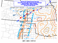
The surface features at 23z clearly showed a stationary front draped from sse of KPUX to ese of KGLD. The associated dryline was analyzed draped south from the stationary frontal boundary through eastern Kiowa County CO into Bacca County as can be seen in the attached MCD.
Sitting just off of HWY 160 on KS/CO border with the tour guests, we had been observing a classic LP supercell that *appeared* to be moving in a westward fashion. A quick look at radar trends and metar/ASOS data revealed that indeed we had a northwesterly moving supercell. A deeper look also revealed that the DL was moving west as well, however the frontal boundary remained stationary. Relocation to the intersection of HWY 160 and CR 56 at roughly 7:50PM MDT. From this position we observed a small funnel and noticed full condensation at roughly 7:55pm. The tornado took on various shapes and ultimately became a classic cone that was also moving west northwest. I will refer you to Pueblo's write up with a few stills from Roger Hill as mine just do not compare:
http://www.crh.noaa.gov/news/display_cmsstory.php?wfo=pub&storyid=52912&source=2
Obviously what I find so interesting about this event is the westward movement of the DL , the associated westward movement of the supecell in regards to tornadogenesis and of course, the westward movement of the tornado. I might add that I did not expect this supercell to produce due to the westward movement, mediocre helecity values and what I thought were "sub-par" CAPE values. In fact, we discussed leaving the storm early with the tour guests in the mood for dinner but opted to stay "another 10 minutes just in case"
Understanding that an eastward moving DL is the result of mixing - I am not so sure and don't' believe that the above event is would be due to such. By definition, the above westward movement would be induced by advection not mixing per se. Thoughts? Ideas?
![Bartlett%20tornado%2052510_mhcomp[1].jpg](/data/attachments/6/6640-7fba2218cc60e308fa2da59d7a1774c7.jpg?hash=f7oiGMxg4w)