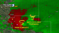
Anticyclonic Tornado in the FFD

Mike Marz

EF3
Joined
Mar 11, 2014
Messages
209
Location
Minneapolis, Minnesota
I just saw a post on Facebook from Tim Marshall regarding the Sulphur, OK tornado on Monday, May 9th. The post is as follows:

"stunning NWS Doppler radar images of the giant Sulphur tornado. Yes, there's an anticyclonic tornado (white dot) northeast of the cyclonic tornado. I've never seen an anticyclonic tornado in a rain-filled forward flank downdraft before. It traveled 12 miles ! Anyone have any pictures of the anticyclonic tornado ?
Thanks to Stu Ostro. (FYI: base reflectivity on left, radial velocity on right)"


aa2ea99201f1b3622c2abf37e30a1282.jpg

I can't wrap my mind around this... I know we have all heard of or seen anticyclonic tornadoes, but I have never heard of one being northeast of the mesocyclone and completely surrounded by FFD precip. I just thought I would throw this out there and see what some of the minds @Jeff Duda here on ST had to say about this. I can't imagine core punching a cell to try and get into position and running into this. I can see running into an occluding cyclonic tornado, but not this. Scary.
 
Last edited:
Hard to imagine getting a tornado at that spot. Seems like it would have to be totally independent of the main updraft. Hard to see how it would be associated with an updraft at all. Crazy.
 
Got me. Never seen that before either. Hopefully there were some research grade mobile Doppler radars that sampled that storm that can provide researchers with some answers.
 
JC-SL-PICTURE-2-png.pngJohnathan Conder from KOCO-TV in OKC suggests that this could be a satellite from the main tornado, amazing possibility, but plausible. I also have a Noob theory, when you drag a paddle through the water, the eddy behind it could be considered cyclonic, while the smaller one behind that is anti-cyclonic. OR, looking at the RV on the right (from Mike Marz post), the light blue areas stacked north and south of each other act as gears in a clock, main tornado cyclonic, due east is anti, go north, cyclonic, look at east helicity? (radial velocity) which produces anti-cyclonic rotation. Still learning obviously but I wonder if this input helps from my layman's perspective?

I was out there but stayed on the Norman/Lake Thunderbird rotation, missed the whole event to my south.
 
Last edited:
I can't imagine core punching a cell to try and get into position and running into this. I can see running into an occluding cyclonic tornado, but not this. Scary.

No doubt. That's a real eye-opener. Not that I core punch much if at all, but that would be a path one would normally think of as relatively "safe." Obviously it's a very rare phenomenon so not sure it's a game-changer as to chase strategy but definitely a new possibility to keep in mind.

Mike thanks for posting, if you see any plausible explanations or theories on the FB thread I hope you won't mind sharing updates here.
 
What a fascinating event. I will have to stare at this loop for quite a while before I even begin to venture a guess as to what's happening. Perhaps some interesting downburst activity between 21:31-21:38 to the east of the roping Wynnewood tornado - reminds me of the intense downburst east of the El Reno (2013) tornado as it weakened near the interstate. The activity precedes the FFD anticyclonic by a few minutes, which flies NNE from there into the FFD.

75dcc5071f0b0eef53fcd5326629d598.gif
 
At the radar animations below you can see a new cell developing in the inflow region of the main supercell, and the anticyclonic tornado develops soon after this to the right of his updraft.
I can't really say very much more about it, but I thought it would be useful to share these radar animations. The first two show compositions from KOUN and KTLX from 8 different elevations, ranging from 0.5 to 5 degree. The last two show the whole lifecycle of the storm, and are composed of compositions from 0.5 and 1.8 degree.

https://dl.dropboxusercontent.com/u/65745050/2016-05-09_KOUN_8composite_5.00s.gif
https://dl.dropboxusercontent.com/u/65745050/2016-05-09_KTLX_8composite_2.50s.gif

https://dl.dropboxusercontent.com/u/65745050/2016-05-09_KOUN_1.00s.gif
https://dl.dropboxusercontent.com/u/65745050/2016-05-09_KTLX_1.00s.gif
 
I'm really glad we didn't stick around in the FFD after the Wynnewood tornado roped out. The storm also produced a high-based anticyclonic funnel at the split between the two updrafts early in it's life so it wouldn't surprise me if the anticylonic left mover it absorbed shortly before spitting out the Sulphur wedge had something to do with it but that's just an uneducated guess.
 
At the radar animations below you can see a new cell developing in the inflow region of the main supercell, the anticyclonic tornado develops soon after this to the right of his updraft.
I can't really say very much more about it, but I thought it would be useful to share these radar animations. The first two show compositions from KOUN and KTLX from 8 different elevations, ranging from 0.5 to 5 degree. The last two show the whole lifecycle of the storm, and are composed of compositions from 0.5 and 1.8 degree.

https://dl.dropboxusercontent.com/u/65745050/2016-05-09_KOUN_8composite_5.00s.gif
https://dl.dropboxusercontent.com/u/65745050/2016-05-09_KTLX_8composite_2.50s.gif

https://dl.dropboxusercontent.com/u/65745050/2016-05-09_KOUN_1.00s.gif
https://dl.dropboxusercontent.com/u/65745050/2016-05-09_KTLX_1.00s.gif

thanks for sharing ! has anyone seen the data TWIRL got ? DOW or pod ? with this tornado passing so close to me , I am really interested in what they got.
 
Back
Top