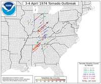
Anniversary of April 3, 1974 "Super Outbreak"

Mr. Corfidi and some other cool folks have a new study out concerning this historic event... and the synoptic and sub-synoptic features that made this outbreak what it was.

http://www.spc.noaa.gov/publications/corfidi/74superoutbreak.pdf

Supplemental slide show:
http://www.spc.noaa.gov/publications/corfidi/74apr3_slides/index.html

This study goes a long way in showing just how much we can't take computer model output at face value, even the very advanced, high resolution output we have today. Just because a model has the grid resolution to handle convective structure doesn't mean it's correct. The models did, however, do a decent job at predicting the larger synoptic scale features of the setup... although there were problems with having the surface low too deep and too slow. This study shows us why it's SO important to have a handle on the mesoscale features of a setup to know what it's capable of, but also how dangerous it is to blow off an outbreak with a good synoptic signal... just because our fancy high-resolution models that are capable of doing "future radar" don't model what you'd expect to happen with such a system. It is ultimately the synoptic scale features that drive the evolution of the smaller scale processes that make or break an event. The atmosphere is fluid; everything is connected. Nothing in the "real world" is actually separated by the thresholds that man has created to quantify such features.
 
Thanks so much for the link to that study, Fred.

I've read the original NOAA analysis of the event so many times, but it's refreshing to have a more contemporary analysis. I think most of us know about the progressive negatively tilted upper trough, the broad elevated mixed layer that overspread a huge territory, and the perfect diurnal timing of the event.

My takeaways from Cordifi's paper are:

1. Even though it was a very potent upper air system, the fact that the upper air trough was not particularly amplified - and the effect this had on inhibiting mid-level cloud cover over the "conveyor belt" in the warm sector - was a factor I had never realized, and an astute observation.

2. The analysis of characteristics of the air masses over the CONUS for the 30 days prior to the event was fascinating. Even though a persistent zonal flow pattern can bring "boring" weather to chasers, the subtle - but in hindsight, obvious - effect that the gulf was wide open for business in the meantime is instructive.

3. Another lesson learned is that downstream atomspheric conditions can be just as important as upstream conditions. That surface front that never quite forced itself all the way through the southeast states says it all.

I've always had this suppositon that an event rivaling the Super Outbreak could never occur in a region other than the approximate region that the Super Outbreak did occur. An event of such areal extent could not happen in the plains proper, IMO. It's hard to put this supposition into words, and goodness knows I couldn't hope to write a formal paper supporting my theory, but reading this paper only confirms my belief.
 
Last edited by a moderator:
Here's an image of the Xenia tornado that you're unlikely to find elsewhere. I scanned it from the pages of the Xenia Daily Gazette. It's not the best resolution in the world, but it's certainly evocative. The white house sits in the foreground with that horrifying, massive black cloud looming behind it. Did the tornado pass by tangentially, or did it hit the house--and the person who took the photo--a minute later? The paper never told.
 

Attachments

  • XeniaTornado.jpg
    XeniaTornado.jpg
    7.8 KB · Views: 361
Randy Bowers and I were just talking about this today and he showed me the link to the satellite loop of the event. It is quite amazing.

I was six years old and out of school for some reason, maybe they let us out because of the weather. I don't remember why. But we were riding from Kingsport, TN to Clinchport, VA to my grandmother's and as we passed through Weber City my dad yelled for me to get in the floor. My mom was yelling. I don't remember the sound of anything, but when I got back up the roof of Scott County Funeral Home was in the road and there was a john boat up in a tree. That's all I can remember. I remember asking my dad about it later and he said that 'they' said it was straight line winds, not a tornado. There is no tornado listed there on the Super Outbreak map, it sits right between numbers 134 and 135.

I know there are a lot of good links about that day, but I have really enjoyed this one. It has links to the NOAA report as well as statistical data, maps, photos, and an explanation of why it happened in layman's terms.
 
Bumping this thread for the the anniversary. Lots of great information here about the event.
 
....although the statement in the first post is no longer quite true (in terms of the daily record). Still hard to believe that with the advances in forecasting and warning, we still had a similar death toll on April 27th, 2011.

What's amazing to me is how similar the two outbreaks were in the way they raked the northwest part of Alabama with several extremely violent tornadoes. I'm inclined to think they were closer together in terms of both violence and tornado count than the raw numbers would lead one to believe, accounting for both weaker/brief tornadoes that may have escaped detection in 1974, and the more stringent application of EF-scale ratings today. I've heard a few people posit that some of the EF-4 tornadoes in 2011 (particularly Tuscaloosa-Birmingham) did more impressive instances of high-end damage across their total path length than some of the F5 tornadoes in 1974. Both that tornado and the Hackleburg-Phil Cambell-Tanner EF5 had single-tornado death tolls much higher than any in 1974.

The thing that still gives the edge to 1974 as "worst" of all time, in my very unqualified opinion, is the lack of violent tornadoes further north over KY, OH, IN in 2011.
 
Back
Top