Luis Mateu
Enthusiast
I have read many explanations about how tornadoes form, like for example http://news.nationalgeographic.com/2015/05/150511-tornadoes-storms-midwest-weather-science or https://en.wikipedia.org/wiki/Supercell. Talks by experts like http://live.som.ou.edu/ also support them. These explanations share the idea of an horizonal vortex that is lifted by the mesocyclone into a vertical position, but this is counterintuitive to me. So I developped an alternative explanation of tornadoes closer to the idea of the whirlpool formed in the drain of a bathtub. I write here to ask if you have observed clues that could support my thinking.
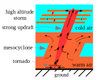
In short my explanation requires a high altitude storm moving above the mesocyclone. The tornado occurs when an updraft forms between the mesocyclone and the high altitude storm. Eventually this will create an unusually strong updraft that sucks the air at the ground raising it to very high in the atmosphere. It is the heavy cold air that pushes the light warm air to go through the updraft. This is the whole picture:
The long explanation is as follows. It is well known that most tornadoes are spawned below the wall cloud of a mesocyclone. A mesocyclone is a big updraft with a width varying from 1 to 8 kilometers, as pictured here:
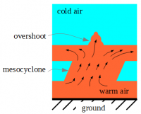
The problem is that the observations show that most of the time the mesocyclone doesn't spawn tornadoes. Although the big tornadoes being at least 1 kilometer wide can be explained as the vortex produced by a mesocyclone, most tornadoes are much narrower than the mesocyclone. So in general tornadoes are produced by a different updraft, not the mesocyclone. That updraft must be narrow. Also consider that a narrow vortex will produce stronger winds than a wide vortex. For example hurricanes with the strongest winds like Andrew had a small eye compared with other hurricanes.
So the mesocyclone is an ingredient, but it is not enough. I think that a second ingredient should be a high altitude storm moving above the mesocyclone like in this picture:
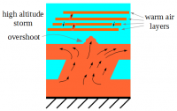
This is possible because the winds at different altitudes have changing directions and so the storms moving at different altitudes. A third ingredient is needed: the overshooting top of the mesocyclone must succeed to pierce the cold air layer that separates the mesocyclone from the storm above, forming a narrow updraft that connects the top of the mesocyclone to the base warm layer of the high altitude storm.
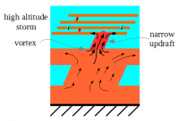
This updraft shall be strong enough to pierce the first cold layer of the high altitude storm. After that it will pierce the second cold layer and then the third and so on. Each time that a cold layer is pierced the updraft becomes stronger. This is because the heavy cold air pierced by the updraft pushes the light warm air bellow to raise through the updraft. The intensity of the updraft is given by the amount of cold air that is pierced. An additional cold layer means bigger intensity.
The base of the updraft will form a vortex like the whirlpool of a drain, but inverted. By this I mean that the air will spin around the updraft before entering it. I will make here a conjecture: this vortex will slowly descend through the mesocylone, progressively sucking the warm air from lower and lower altitudes. This is due to the intensity of the updraft and because there is no cold layer stopping it. See this picture:
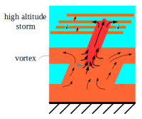
Finally the tornado forms when the vortex reaches the ground as shown by the first picture of this post. And that is my explanation for tornadoes. They are narrower and go higher than the mesocyclone. As you can see, my reasoning is very different from the explanation in http://news.nationalgeographic.com/2015/05/150511-tornadoes-storms-midwest-weather-science.
One point in favor of my thinking is that it also can explain multiple vortex tornadoes: because the mesocyclone is so wide, there is enough place above it to form 2 or 3 updrafts connecting the mesocyclone to the high altitude storm, and therefore they will form a dual or triple vortex tornado.
So here are my questions:
Have you read something similar to my explanation before?
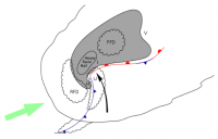
While chasing storms have you observed a storm moving above another storm? Moving above a mesocyclone? I think that the key to see what happens above the mesocyclone is to observe it from the direction shown by the green arrow in this picture (original by Vanessa Ezekowitz - Wikipedia), but 10 to 20 kilometers far away:
Finally, is it possible to simulate this scenario with computers? If it is too complex, it would help to reduce the simulation to just the strong updraft inside the mesocyclone to determine if the vortex descends or not.
Thanks.
In short my explanation requires a high altitude storm moving above the mesocyclone. The tornado occurs when an updraft forms between the mesocyclone and the high altitude storm. Eventually this will create an unusually strong updraft that sucks the air at the ground raising it to very high in the atmosphere. It is the heavy cold air that pushes the light warm air to go through the updraft. This is the whole picture:

The long explanation is as follows. It is well known that most tornadoes are spawned below the wall cloud of a mesocyclone. A mesocyclone is a big updraft with a width varying from 1 to 8 kilometers, as pictured here:

The problem is that the observations show that most of the time the mesocyclone doesn't spawn tornadoes. Although the big tornadoes being at least 1 kilometer wide can be explained as the vortex produced by a mesocyclone, most tornadoes are much narrower than the mesocyclone. So in general tornadoes are produced by a different updraft, not the mesocyclone. That updraft must be narrow. Also consider that a narrow vortex will produce stronger winds than a wide vortex. For example hurricanes with the strongest winds like Andrew had a small eye compared with other hurricanes.
So the mesocyclone is an ingredient, but it is not enough. I think that a second ingredient should be a high altitude storm moving above the mesocyclone like in this picture:

This is possible because the winds at different altitudes have changing directions and so the storms moving at different altitudes. A third ingredient is needed: the overshooting top of the mesocyclone must succeed to pierce the cold air layer that separates the mesocyclone from the storm above, forming a narrow updraft that connects the top of the mesocyclone to the base warm layer of the high altitude storm.

This updraft shall be strong enough to pierce the first cold layer of the high altitude storm. After that it will pierce the second cold layer and then the third and so on. Each time that a cold layer is pierced the updraft becomes stronger. This is because the heavy cold air pierced by the updraft pushes the light warm air bellow to raise through the updraft. The intensity of the updraft is given by the amount of cold air that is pierced. An additional cold layer means bigger intensity.
The base of the updraft will form a vortex like the whirlpool of a drain, but inverted. By this I mean that the air will spin around the updraft before entering it. I will make here a conjecture: this vortex will slowly descend through the mesocylone, progressively sucking the warm air from lower and lower altitudes. This is due to the intensity of the updraft and because there is no cold layer stopping it. See this picture:

Finally the tornado forms when the vortex reaches the ground as shown by the first picture of this post. And that is my explanation for tornadoes. They are narrower and go higher than the mesocyclone. As you can see, my reasoning is very different from the explanation in http://news.nationalgeographic.com/2015/05/150511-tornadoes-storms-midwest-weather-science.
One point in favor of my thinking is that it also can explain multiple vortex tornadoes: because the mesocyclone is so wide, there is enough place above it to form 2 or 3 updrafts connecting the mesocyclone to the high altitude storm, and therefore they will form a dual or triple vortex tornado.
So here are my questions:
Have you read something similar to my explanation before?
While chasing storms have you observed a storm moving above another storm? Moving above a mesocyclone? I think that the key to see what happens above the mesocyclone is to observe it from the direction shown by the green arrow in this picture (original by Vanessa Ezekowitz - Wikipedia), but 10 to 20 kilometers far away:

Finally, is it possible to simulate this scenario with computers? If it is too complex, it would help to reduce the simulation to just the strong updraft inside the mesocyclone to determine if the vortex descends or not.
Thanks.
