John Erwin
EF5
**rescued post**
John Farley
Joined: 01 Apr 2004
Posts: 170
Location: Edwardsville, IL
Posted: Tue Sep 12, 2006 2:04 pm Post subject: 9/11/06 REPORTS: IL/MO As a surface low drifted across northern Missouri, I was figuring by around mid-day that if we get could enough clearing and heating behind the precipitation that moved through IL in the morning, there could be a decent chance of rotating storms over parts of IL and possibly IN and extreme eastern MO. The models were predicting CAPE around 1000-2000 (which easily verified) and there was both directional shear and divergent upper winds, although the lower and mid-level winds were rather weak. But with the RUC predicting temps as high as 85 in east central MO by late afternoon, I thought that it might be enough to get things going. I waited at home in Edwardsville, ready to head out if anything interesting popped up. I figured that, based on where the clearing and heating were occuring, west-central IL looked like it might be the best bet, which would make it a local chase for me.
By 3:00 p.m., a broken line of thunderstorms had formed from just west of Quincy, IL southwestward to just west of Columbia, MO. Also at 3:00, SPC shifted its slight risk area westward from central IL and central IN to the area I had identified as the one likely to have the best instability, including west-central IL and much of east-central and northeast MO. Not wanting to get backed up to the Mississippi River and the St. Louis metro area as the storms moved east, I decided to try to intercept the storms in IL once they crossed the Mississippi River. I figured my best chance would be somewhere southeast of Quincy, since it appeared that the best heating and dynamics would be south of I-72. (That did not turn out to be entirely true, but my strategy turned out to work reasonably well.)
Leaving around 3:20, I headed through urban Madison Co., then headed north from Godfrey on U.S. 67 to Jerseyville, where I figured I could either continue to the north or cut west toward the Illinois and/or Mississippi Rivers. By the time I was in Jerseyville, the storms were still far to my west, so I decided to cut west there and then either north on 100 or across the Illinois River and farther west. It was evident when I got to 100 that I still needed to get farther west, so I crossed the IL river at Hardin and then turned west on route 96 at Kampsville - a route that would take me to the Mississippi River valley and eventually on to the northwest toward Quincy. I was sure the line of storms would be somewhere southeast of Quincy, though I could not even see anvil until I was west of Kampsville. Heading northwest along the foot of the bluffs into Pike Co., however, I began to see updraft towers straight ahead. Around 5:15 I heard SVR warnings for Callaway County in MO, far to my southwest, but also for Adams County in IL (where Quincy is located) ahead of me. As I got closer, though, I could see what appeared to be the tail end storm of the cluster not too far northwest of where U.S. 54 crosses IL route 96, which I was still on, in Pike Co. This was not the severe-warned storm, but I soon decided to stay with it because it would have less contaminated inflow than the severe warned one to its N or NNE, and because it was looking quite good. After watching it for maybe 15 or 20 minutes, around 6:00 p.m. I noticed some rising scud under the updraft, which in a matter of 2 or 3 minutes evolved into this wall cloud:
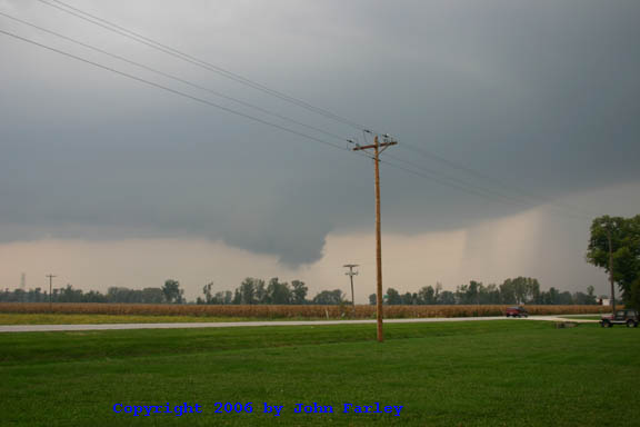
This picture was taken looking to the WNW from about a mile northwest of Rockport, IL; note the precipitation shafts (I would suspect some hail in there) to the right (east or ENE) of the wall cloud. Here is a more zoomed picture taken shortly after the one above:
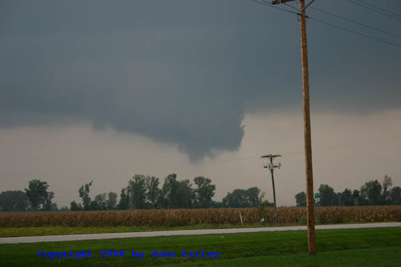
When I took this picture, I really thought that this might be about to produce; I had noticed a little rotation by now (though it was never all that pronounced) and I thought the lowering under the center of the wall cloud might be a developing funnel. However, that is as far as it got, and within less than 5 minutes, the wall cloud was gone.
However, the show was not over yet. After a few more minutes, I decided to move south as the storm, continuing to cycle and backbuild, was almost on top of me. It took a while to find another good viewing spot - in part because the corn was tall; farmers, PLEASE get out there and harvest it! But by the time I did, the storm had formed a second, larger wall cloud:
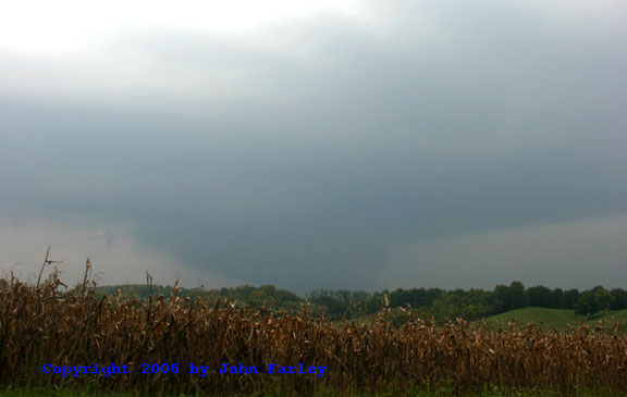
I thought this looked large and dangerous enough that I called it in to the St. Louis NWS. This picture was taken looking north from just southeast of Rockport, IL. Unfortunately, the position of the bluffs blocks the view of the bottom of the wall cloud. As the storm was getting away from me, I decided to return back to route 54 and take it northeast from where it crosses route 96. When I got to the top of the bluffs and a place where I had a clear view, the wall cloud was still there, but it was looking less organized, and it clearly did not reach near the ground. Over the next 10 minutes or so, it completely morphed into a shelf cloud, spreading east along the leading edge of the storm and with precip filling in behind it to its NW. Clearly, this storm no longer appeared likely to produce, and in any case, since it was now past 7:00 p.m., it was getting dark. I decided to take 54 to Pittsfield where I could go east and get back on 100 or 67 to return home, and was hoping the road would turn east before I reached the leading edge of the storm. It did not, so I was in driving rain and gusty wind until I got to route 100 where I could turn south.
The only warning ever issued for this storm was a flash flood warning around 7:30, which verified with radar indications of 3-5 inches of rain in a narrow band from just northeast of Rockport to near Pittsfield. I did, however, notice some large tree branches down in Pittsfield and east of there, so the storm did produce some fairly strong wind. Had it been anywhere except right over the Mississippi River bluffs, it would have been easy to chase, since with the backbuilding and cycling it was only effectively moving 5 or 10 mph. All in all, a nice fall chase, even though the dyamics just weren't quite enough to get any tornadoes out of this storm or any of the others in the line, though one farther northeast in Fulton Co. did have a couple TOR warnings.
Total chase distance: approximately 220 miles.
_________________
John Farley
Edwardsville, IL
John Farley
Joined: 01 Apr 2004
Posts: 170
Location: Edwardsville, IL
Posted: Tue Sep 12, 2006 2:04 pm Post subject: 9/11/06 REPORTS: IL/MO
By 3:00 p.m., a broken line of thunderstorms had formed from just west of Quincy, IL southwestward to just west of Columbia, MO. Also at 3:00, SPC shifted its slight risk area westward from central IL and central IN to the area I had identified as the one likely to have the best instability, including west-central IL and much of east-central and northeast MO. Not wanting to get backed up to the Mississippi River and the St. Louis metro area as the storms moved east, I decided to try to intercept the storms in IL once they crossed the Mississippi River. I figured my best chance would be somewhere southeast of Quincy, since it appeared that the best heating and dynamics would be south of I-72. (That did not turn out to be entirely true, but my strategy turned out to work reasonably well.)
Leaving around 3:20, I headed through urban Madison Co., then headed north from Godfrey on U.S. 67 to Jerseyville, where I figured I could either continue to the north or cut west toward the Illinois and/or Mississippi Rivers. By the time I was in Jerseyville, the storms were still far to my west, so I decided to cut west there and then either north on 100 or across the Illinois River and farther west. It was evident when I got to 100 that I still needed to get farther west, so I crossed the IL river at Hardin and then turned west on route 96 at Kampsville - a route that would take me to the Mississippi River valley and eventually on to the northwest toward Quincy. I was sure the line of storms would be somewhere southeast of Quincy, though I could not even see anvil until I was west of Kampsville. Heading northwest along the foot of the bluffs into Pike Co., however, I began to see updraft towers straight ahead. Around 5:15 I heard SVR warnings for Callaway County in MO, far to my southwest, but also for Adams County in IL (where Quincy is located) ahead of me. As I got closer, though, I could see what appeared to be the tail end storm of the cluster not too far northwest of where U.S. 54 crosses IL route 96, which I was still on, in Pike Co. This was not the severe-warned storm, but I soon decided to stay with it because it would have less contaminated inflow than the severe warned one to its N or NNE, and because it was looking quite good. After watching it for maybe 15 or 20 minutes, around 6:00 p.m. I noticed some rising scud under the updraft, which in a matter of 2 or 3 minutes evolved into this wall cloud:

This picture was taken looking to the WNW from about a mile northwest of Rockport, IL; note the precipitation shafts (I would suspect some hail in there) to the right (east or ENE) of the wall cloud. Here is a more zoomed picture taken shortly after the one above:

When I took this picture, I really thought that this might be about to produce; I had noticed a little rotation by now (though it was never all that pronounced) and I thought the lowering under the center of the wall cloud might be a developing funnel. However, that is as far as it got, and within less than 5 minutes, the wall cloud was gone.
However, the show was not over yet. After a few more minutes, I decided to move south as the storm, continuing to cycle and backbuild, was almost on top of me. It took a while to find another good viewing spot - in part because the corn was tall; farmers, PLEASE get out there and harvest it! But by the time I did, the storm had formed a second, larger wall cloud:

I thought this looked large and dangerous enough that I called it in to the St. Louis NWS. This picture was taken looking north from just southeast of Rockport, IL. Unfortunately, the position of the bluffs blocks the view of the bottom of the wall cloud. As the storm was getting away from me, I decided to return back to route 54 and take it northeast from where it crosses route 96. When I got to the top of the bluffs and a place where I had a clear view, the wall cloud was still there, but it was looking less organized, and it clearly did not reach near the ground. Over the next 10 minutes or so, it completely morphed into a shelf cloud, spreading east along the leading edge of the storm and with precip filling in behind it to its NW. Clearly, this storm no longer appeared likely to produce, and in any case, since it was now past 7:00 p.m., it was getting dark. I decided to take 54 to Pittsfield where I could go east and get back on 100 or 67 to return home, and was hoping the road would turn east before I reached the leading edge of the storm. It did not, so I was in driving rain and gusty wind until I got to route 100 where I could turn south.
The only warning ever issued for this storm was a flash flood warning around 7:30, which verified with radar indications of 3-5 inches of rain in a narrow band from just northeast of Rockport to near Pittsfield. I did, however, notice some large tree branches down in Pittsfield and east of there, so the storm did produce some fairly strong wind. Had it been anywhere except right over the Mississippi River bluffs, it would have been easy to chase, since with the backbuilding and cycling it was only effectively moving 5 or 10 mph. All in all, a nice fall chase, even though the dyamics just weren't quite enough to get any tornadoes out of this storm or any of the others in the line, though one farther northeast in Fulton Co. did have a couple TOR warnings.
Total chase distance: approximately 220 miles.
_________________
John Farley
Edwardsville, IL
