John Farley
Supporter
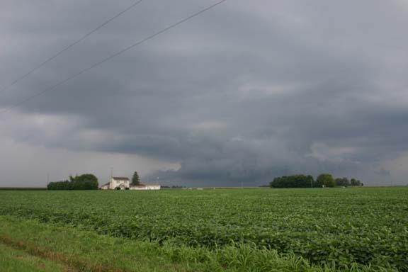
I chased today in central and SW Illinois. After what happened yesterday (when I watched weather all afternoon until around 5:00, then headed off to do other things - just before the storms blew up in central IL, producing a half-dozen tornadoes), I was not going to let a day with good potental get away. And with RUC progging the very high CAPE (4000 or higher) in SE Iowa to move east into central Illinois by 21Z, I figured there was at least a chance of a repeat show. As it turns out, I never got on one SVR or TOR warned storm - FFW was the best I could muster - but still it was not a bust, because I saw two interesting things. First, a few miles north of I-72 between Springfield and Decatur, I saw this:

Now, you probably think, as I did, that this was a wall cloud. But what it actually turned out to be was the beginning of a process of the base of the storm re-forming at a lower level, as the storm moved into the area where 3-6 inches of rain had fallen the night before. As the storm continued east, the entire base re-formed at this lower level. I assume as the storm moved into the more humid environment - it remained very warm and sticky, even when I poked to within a half mile or so of the heavy rain - the LCL was lower, and this caused the storm to form a new base at a lower level. By the time the storm was north and northeast of Decatur, the entire base was down to the level of the base in this feature that looks like a wall cloud.
I was on this storm from around 2:00 just northeast of Springfield to around 4:30 ENE of Decatur. But by then it became apparent that all the storm was going to do was produce copious amounts of rain - and flooded roads were becoming more and more of an issue. I had to make one detour where a road was closed due to flooding, and several other places small amounts of water were running over the road. I headed back west on I-72 to Springfield, hoping something would pop in the area west of there where RUC had progged CAPE as high as 4500. That did not happen, as clouds from earlier storms and the southward push of the pre-frontal storms took care of that.
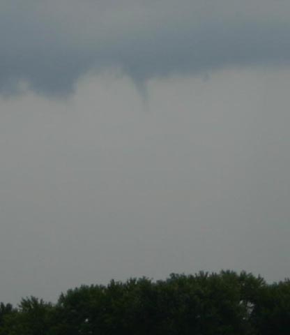
But it turned out I was not through yet. As I neared home, I noticed a storm intensifying to my southeast. It formed a couple large, scuddy lowerings that went nearly to the ground. I decided to investigate, heading away from rather than toward home when I exited I-55 at IL route 143. I headed east toward Marine then south on route 4 to I-70, where I stopped and watched the storm. To my surprise, I was rewarded with a small needle funnel:

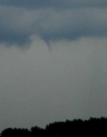
The funnel never went more than 1/6 of the way to the ground, but it persisted for 4 or 5 minutes. I am quite certain it was a funnel, as it maintained the funnel shape the whole time and its edges were much smoother and more distinct than any of the surrounding scud - and it was also directly below a strong updraft. I did not call it in, as it was never anywhere near far enough down to represent a threat. Here is another picture from a couple minutes before the first (contrast slightly enhanced):

This occurred around 7:05 p.m. and persisted until around 7:10. Location of the funnel was southeast of Marine, IL and southwest of Highland.
All in all, not a bad chase for not seeing any storms that technically met the definition of "severe."

Now, you probably think, as I did, that this was a wall cloud. But what it actually turned out to be was the beginning of a process of the base of the storm re-forming at a lower level, as the storm moved into the area where 3-6 inches of rain had fallen the night before. As the storm continued east, the entire base re-formed at this lower level. I assume as the storm moved into the more humid environment - it remained very warm and sticky, even when I poked to within a half mile or so of the heavy rain - the LCL was lower, and this caused the storm to form a new base at a lower level. By the time the storm was north and northeast of Decatur, the entire base was down to the level of the base in this feature that looks like a wall cloud.
I was on this storm from around 2:00 just northeast of Springfield to around 4:30 ENE of Decatur. But by then it became apparent that all the storm was going to do was produce copious amounts of rain - and flooded roads were becoming more and more of an issue. I had to make one detour where a road was closed due to flooding, and several other places small amounts of water were running over the road. I headed back west on I-72 to Springfield, hoping something would pop in the area west of there where RUC had progged CAPE as high as 4500. That did not happen, as clouds from earlier storms and the southward push of the pre-frontal storms took care of that.
But it turned out I was not through yet. As I neared home, I noticed a storm intensifying to my southeast. It formed a couple large, scuddy lowerings that went nearly to the ground. I decided to investigate, heading away from rather than toward home when I exited I-55 at IL route 143. I headed east toward Marine then south on route 4 to I-70, where I stopped and watched the storm. To my surprise, I was rewarded with a small needle funnel:

The funnel never went more than 1/6 of the way to the ground, but it persisted for 4 or 5 minutes. I am quite certain it was a funnel, as it maintained the funnel shape the whole time and its edges were much smoother and more distinct than any of the surrounding scud - and it was also directly below a strong updraft. I did not call it in, as it was never anywhere near far enough down to represent a threat. Here is another picture from a couple minutes before the first (contrast slightly enhanced):

This occurred around 7:05 p.m. and persisted until around 7:10. Location of the funnel was southeast of Marine, IL and southwest of Highland.
All in all, not a bad chase for not seeing any storms that technically met the definition of "severe."
