John Farley
Supporter
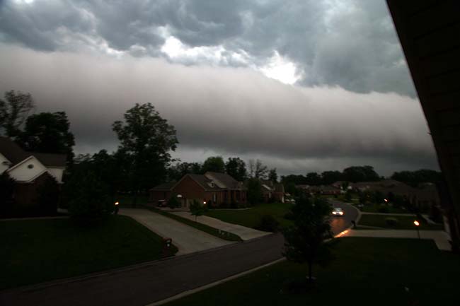
I am surprised there is no discussion of today's storms. I probably should have chased, but did not, because as the storm approached, it looked totally like a bow echo, and I did not really want to put an intensifying bow echo moving 45 mph between me and home. However, just before the storm reached Edwardsville, it formed a meso along the leading edge just north of the apex of the bow, and evolved into an HP supercell-type structure. We were not hit too hard in Edwardsville, but the severity of the storm to our south took out the power in all of Edwardsville and many nearby communities - so after keeping power through Wednesday's storms, we are now dark. So, after icing the perishable stuff in the refrig in a cooler, I headed to campus to get power and a wifi connection.
The number of people without power, after falling this morning to 360,000, is now back up to nearly 570,000. Many who had just gotten power back lost it again, with damage reports all over the STL area. Damage is especially severe along a line from the Maryville/Troy area to the ESE, with media reports of a possible tornado. Areal photos on the KMOV web site suggest that possibility. At the least, there is a long, continous path of major damage in Clinton Co. and possibly southeast Madison and NE St. Clair Counties. So maybe if I had chased, I might have seen a tornado, which I did not see as likely until the storm was nearly on top of me. Now I just hope to get power back sometime soon.
The number of people without power, after falling this morning to 360,000, is now back up to nearly 570,000. Many who had just gotten power back lost it again, with damage reports all over the STL area. Damage is especially severe along a line from the Maryville/Troy area to the ESE, with media reports of a possible tornado. Areal photos on the KMOV web site suggest that possibility. At the least, there is a long, continous path of major damage in Clinton Co. and possibly southeast Madison and NE St. Clair Counties. So maybe if I had chased, I might have seen a tornado, which I did not see as likely until the storm was nearly on top of me. Now I just hope to get power back sometime soon.
")