6/9/06 REPORTS: SD/IA/NE

Joined
Feb 22, 2004
Messages
916
Location
Golden, CO
Michael and I left our target of Norfolk, NE around noon when it was clear that the setup was not working out and headed towards Ogallala, NE where we were content to just skip the day and setup for Saturday in the NE panhandle. As we approached North Platte we could see that a CU field was developing to our north along the cold front and cells were beginning to fire. We headed into the sand hills were we intercepted the tornado warned cell in Cherry County, NE and witnessed one of the best mesos we've seen all season! Many times it tried to spin up scud in it's updraft but we never could confirm a touchdown.

Did anyone else see the crazy privately owned 737 jet shooting touch-and-go's at the Norfolk Airport?? That was almost as exciting and unexpected as anything I've seen this storm season! :blink:

20060609_M1_sm.jpg

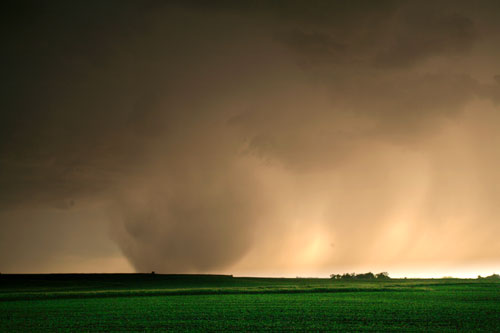
Meso in Cherry County, NE as it was tornado warned

20060609_M2_sm.jpg

Interesting lowerings were seen but no touchdowns confirmed

Edit: The elevation in central NE is ~3400' (where we saw this storm) as opposed to ~1700' in eastern NE, with the same upper 50 Tds the LCLs in central NE had a much better chance to produce. Something I noticed while checking my GPS in the two locations today.

Edit to Bobs comment below: LOL - yeah probably a little of both! 2006 has made us jump into some places and setups a good year would never take us. One of the roads we were on at one point was actually a single lane paved road that went north for miles made out of old recycled asphalt. The sand hills are truely something to be experienced!
See you out there!
Verne
 
Just got back from a long chase today. Met up with Rory Groves and joined a caravan of SUV's at Beresford, SD and chased east from there into Iowa. Lots of chasers out there - never seen so many in my last two years of chasing. Saw some "bigger names" as well so it felt good that whether you've got two months or two years or 20 years chasing, we all relatively busted today. Still had a good time though. Will post the full report and pictures tomorrow.

EDIT: Full chase log and pictures done and posted on my blog.
 
Chased the main cell that was West of Ponca on Hwy 20, i followed it along Hwy 20 east for a bit, as it was moving northeast so i booked it to I-29 north and sat off the Jefferson NE exit , an just watched some rain shafts and the microburst occur, it was pretty cool when the wind kicked in... that was the most exciting part. From reports on the radio near Meckling this storm produced 40mph wind gust and pea size hail. i wasnt expecting much today but im hitting every chase chance i get even if the setup doesnt favor anything good. Anwyays i ended up getting back on Hwy 20, but driving east and stopping near Lawton IA where the cell started to get some lightning going cloud to cloud at its top, it then fizzles out a bit and off to the northeast it goes and i called it quits. On the way back i was watching the storms near Tekhema NE, to Moville IA line, the lighting wasnt very frequent but there were some nice crawlers and c2g bolts , i captured a few on vid and will psot later when i can.

This year is seriously lacking tornadoes ughh ;-) we take what we get and suck it up..

DSC05443.jpg


DSC05464.jpg


DSC05462.jpg


DSC05471.jpg
B)
 
Good evening all,

We were on the storm since the very start. The insane downburst/hail shaft was the highlight of the day.

[attachmentid=370]

[attachmentid=371]


Good luck tomorrow,

Martin Kucera
FloridaLightning.com
 
Also saw the hailshafts. Made it into Vermillion, SD in time to see the storm start to deteriorate. On the way back home to Hastings I noticed the tornado warning near Valentine. Also saw numerous chasers. Nice rainbow near Vermillion. South Dakota is a beautiful state, but would be nice to have more road options.
 
First observed a brief anticyclonic attempt SW of Vermillion, SD where the updraft was on the left flank. This was the original cell for the severe warning, it died out quite quickly. I went East through some back roads only to find that they turned to wet quicksand, but amazingly managed to trudge through with my Mazda. The cell just to the S flared up and took a brief right turn on the WF. As others have noted, the highlight was the rain/hail shaft from the high base and the neat look of it near the surface. Went east to Akron, IA and watched the cell fall apart. I went south through the breathtaking green hills of NW IA and caught the Sioux City cell. It had a brief window where the updraft came down and looked like it ingested a bit of streamwise voriticty, but that didn't last very long.

Congrats to Verne for his catch of that tornado warned cell. Saw lots of chasers/ tour groups out yesterday, definately a hard pressed year for lower LCL's under this ridge.
 
Peggy Willenberg and I sat in Chili's in Sioux City for about 4 hours monitoring data and waiting. After initiation we drove up the interstate ~20 miles and intercepted the cell with nice downbursts and rain shafts. We followed it into Iowa and decided to abort just before sundown and eat at the Golden Pheasant located in the middle of nowhere.

Dinner at the Golden Pheasant was one of the highlights! The restaurant had 2 of the largest parties they ever had (both wedding rehearsal dinners, 115 people total) with only 3 waitresses. Peggy and I decided to join the fun and have steak to celebrate the rain/possible hail shaft that briefly resembled a tornado when viewed from the East :D Hey, we were just happy to see a storm! It was only our second real chase of the season. We're hoping the upper midwest picks up in June so we can at least see some hail this year...or maybe some good structure.

Nice storm in Cherry county Verne! I'm glad someone was out there to see it. It looked like the best thing on radar for a while. We have chased in Cherry county on that one lone road and we know how difficult it is to actually intercept a storm out there. Congrats!

060906_03.jpg


060906_04.jpg


060906_05.jpg


060906_07.jpg


060906_09.jpg


060906_10.jpg


060906_13.jpg


Melanie Metz
http://www.twistersisters.com
 
06/09/06 Wyoming Chase.

I was out in a different target area on the tornado warned cell in Eastern Wyoming.

The chase report for this storm and for the last three days is up on my blog.

My Webpage Blog

060906_wy1.jpg


Also on 06/08/06 I was chasing in Montana.

060806_floodO.jpg


Here is the link to the 06/08/06 Flash Flooding video.
06/08/06 Montana Flash Flooding Video

The flooding pretty much destoryed this farm.
 
<div class='quotetop'>QUOTE("Johnathan Brouwer")</div>
We, myself, Clay Stahlka and Joe Walters (inchase group)left Fort Wayne, Indiana with a target city of Des Moines...recalculated and targeted Carroll, Iowa...no development except cold front clouds pushing towards us. which btw if you are ever in Carroll, Iowa a great vantage point for a NW view is in the parking lot of the National Guard facility. We saw lots of great lightning while repositioning to south of Omaha.

At this time, Sat afternoon-night we decided to move to the stuff between KC, MO and St Loius. A long story short, nothing. Found some good outbound bands, and lots of rain and lighning. We had a lot of waiting so we found a greatplace to eat in Sedalia, Mo called The Mighty Melt, very high on our list for the future, nice people too!

Anyway we headed north on 19 and positioned for a overrun in Swiss, MO nice little storm, mso and tvs popped on our stormlab radar. It was differnt and and dissapointing at the same time. But we were doing what we we love so no complaints....

No photos, but congrats out to others who posted here, good shots!

regards, johanthan brouwer [/b]
 
Back
Top