6/7/2005: REPORTS C. Plains

Status
Not open for further replies.
Joined
Mar 4, 2004
Messages
162
Location
Kalamazoo, Michigan
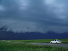
Began the day in Pierre, SD targeting a region from Phillip to
Kadoka, SD. After a hardy brunch, Brian M, Kinney A, and myself found
ourselves timelapsing sheep and percolating cu S of Kadoka. Waited as
enhanced area of cu translated into two noteworthy cells on radar.

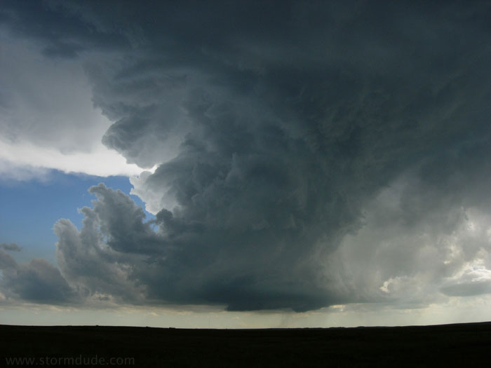
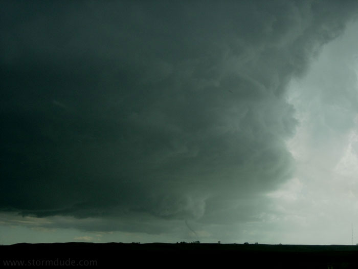
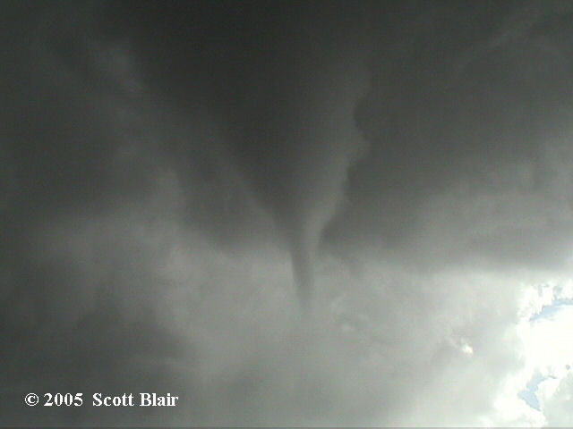
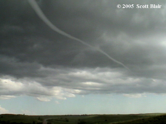
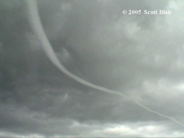
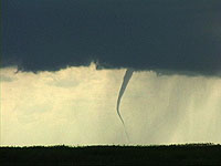
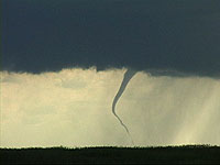
Skipping ahead -- Witnessed a beautiful photogenic LP supercell from
birth to tornadogenesis in western Jackson Co. SD (near Potato
Creek). Two tornadoes; followed by a distant third out of the
northern most storm (assumming it was in S. Hakkon Co.).

Brian will reflect more on this along w/ photos at
www.stormeffects.com -- as Im on his computer.

This made the 2005 season for me!

..Blake..
 
Just got back from a fun backyard chase here in MN/WI. Ran north after some cells went up near Brainerd, MN. Storms crapped out after they passed over Lake Mille Lacs but a new multicelluar cluster formed just 20 miles east. Was about to call off the day until multicell finally got its act together and went tornado warned in Pine County, MN. The storm was moving east at 15mph along a highway that had a bridge over the St. Croix river into Wisconsin (SCORE!). We chased it and saw a brief funnel before outflow shredded it to pieces. We dropped south to around the Siren, WI area ahead of newly developing supercell 20 miles to the south. This storm was also being undercut, but provided some decent structure.

Overall a fun day for an iffy setup.

Funnel 1 NE of Cloverdale, MN

cloverdale.jpg
 
got to the SD storms after they turned linear. saw a very pretty shelf near Mosher SD and saw a couple of gustnadoes while being chased back to Winner. watched very intense in cloud lightning display as storm passed over Winner, where I'm staying for the night.

sq050607cmed.jpg
 
Wow Jeff! I was in Tripp County and Winner as well...would have been great if Jay could have been there instead of him driving back to Austin the other day, but it seems he wasn't expecting any of his friends to be chasing in SD today.

Regards,

Mike
 
Wow, wow, wow what an amazing supercell thunderstorm southeast of the Badlands, SD. We drove through the eastern part of the park after paying the $10 entry fee.... it was well worth it. We (with Jay Antle and Matt Crowther) sat at a high spot in the park with chasers Bobby Prentice and company. We then headed south then east on hwy 44 when the first tornado appeared as a narrow cone funnel about halfway to the ground. The next tornado was a serpentine rope tornado underneath one of the best barrell supercell updrafts I've ever seen.

I was fortunate to get some decent wide angle stills of the tornado underneath the mammoth LP updraft. What a sight. The hordes were certainly out, but that didn't bother us one bit. Met up with Jim Leonard as well for a time as we headed north on a gravel state road (#63) back to the Interstate as the "wall of death" was rapidly approaching. We made it back to I-90 at Belvidere and fogged it east with the supercell in front of us and the wall of death behind us. I got some decent stills, as well, of the menacing tiered shelf cloud from Murdo to Presho along the interstate. Lots of chasers out in this area today.

<img src=http://www.underthemeso.com/albums/2005jun07/DSC37641.sized.jpg>
<img src=http://www.underthemeso.com/albums/2005jun07/DSC37791.sized.jpg>
<img src=http://www.underthemeso.com/albums/2005jun07/DSC37771.sized.jpg>
<img src=http://www.underthemeso.com/albums/2005jun07/DSC38181.sized.jpg>
<img src=http://www.underthemeso.com/albums/2005jun07/DSC38411.sized.jpg>

1024x680 images at
http://www.underthemeso.com/gallery/view_a...mName=2005jun07

Mike U
 
Great chase today. I got on the storm in Jackson county South Dakota. The storm took a while to get organized. It started to look like it was going to produce a tornado long before it ever did. The storm was over an Indian reservation when it went tornadic. The roads were terrible. I was driving what was a regular country road on the map, but in reality it was literally tire tracks through a pasture. A couple of miles into it there was a gate and I could go no further. When I was driving back to the main road a funnel began to take shape. Here is a picture of the funnel at that time (around 5:55)

my.php
[/url][/img]

A couple minutes later the tornado touched down. It was 5:59.

my.php
[/url][/img]

The tornado lifted up and touched back down a couple times and then roped out.
I had to drive North and cut back to the East. There weren't any road options. You had to stay on the one paved road. Side roads were non existent today. It ended up working out alright though. Once I caught back up to the meso the RFD puched a clear slot.

my.php
[/url][/img]

A little later there was another funnel that made it about half way to the ground. I would put up a video still of it, but my internet connection sucks and it took me forever to load the pictures I have. This funnel was over some valley with huge white rock formations. It was incredible. There was good rotation and vertical motion. Chasers were all over the place and the scenery was unbeatable. I am sure someone will put up a picture. If not I will put one up tomorrow morning.

The storm had incredible structure later in the evening. I had to fly down the highway to get ahead of it. Here is a picture from a few miles ahead of the mesocyclone.

my.php
[/url][/img]

Further down the highway Wurman and the DOWs were parked on an overpass where I was. Here is a shot of the DOW and the F-250/tank with the storm in the background.

my.php
[/url][/img]

All in all, it was a great day. I got to meet Amos today while we were both searching for a wifi spot in some little reservation town. I bumped into a guy that I talked to in SW Kansas last Thursday (can't remember his name). The storm was all I could ask for. The tornado wasn't the strongest one I have ever seen, but it was a tornado none the less. I can't wait to see what the rest of the week will bring.
 
June 7, 2005 - Wanblee, SD Tornado

jun705tor1a.jpg

jun705tor1b.jpg

jun705tor1c.jpg


I observed one tornado lasting six minutes southwest of Wanblee, SD. I elected to stay close to rapid rotation just to my south and witnessed the tornado at close range. The tube was a tapered cone and transitioned into a long, pencil-thin rope. Other than the tornado, the structure was amazing throughout the day. More photos will be added to my website.

Scott Blair
http://www.targetarea.net/
 
Having laptop problems and very short on time (what's new?), so the fast report is that we observed a long-lived supercell and associated tornado in Jackson County, South Dakota last evening. Tornado touched down at 2248z and lasted about seven minutes from under the base of a gorgeous LP that was transitioning into a classic supercell. Though it touched down several times, chasers who were directly under the base report that this was a single tornado.

Chased this for three hours back up to Interstate 90 where it displayed tightly sculpted banding, including eddies in the striations which I captured in my stills. The eddies are a more rare and remarkable phenonema than the tornadoes. Eric Nguyen commented he hadn't seen this feature since 1998.


Tornado forming under great LP / click to enlarge


6_7_2005%205_54%20PM_0006correctedthumb.jpg

Video grab of tornado, Jackson County, SD

6_7_2005%205_54%20PM_0007correctedthumb.jpg

Video grab


Image from I-90 later in the day, eddies in the striations! Click to enlarge
 
Had a very good day yesterday, witnessed a beautiful tornado in the distance and a absolutely amazing supercell from near Cactus, SD. We followed it all the way back to Murdo, in which we took cover in a gas station/resteraunt, away from the hail/severe winds (>65MPH gusts). We later all had a ball together (me, Kurt Hulst, Dan Robinson, Amos Magliocco and Eric Ngyuen) playing with Scott Blair's extremely large hail. It was once 5" inches, but it melted to around 3" inches by the time we brung it into the resteraunt...

Heres just a few pics from yesterday (don't have too much time upload right now)...

672005644PM0002.jpg

tn_CRW0024.jpg

tn_CRW0032.jpg

tn_CRW0053.jpg

tn_6720051004PM0001.jpg

tn_6720051036PM0001.jpg


I will probably have the whole log/photo set on my site in a couple of days... It maybe longer, considering how active this weekend is gonna be!
 
Quite a fun chase indeed. Wish I would have got on the cell early enough to view the tornado. But congrats to all who did. I am more than happy to watch, photograph the beautiful structure. A very nice mesocyclone indeed. Seems that by 7:15 a huge chaser convergence was underway. Meet up with Nick, Dan and Kurt and talked with the outlaw chasers of the Ozarks. Then the outflow came in and we all took off. Seems like this storm was bowling tumbleweeds at cars over the interstate. I think I hit 20 maybe 30. LOL. From Chamberlain back to I-29 I constantly stopped to photograph lightning and then drove north on I-29 coming into the squall line at the end. Not much for blinding precipitation but some serious winds indeed. The wind forced the rain down on the ground quickly and then seemed to push it aside creating a layer of running rain on the ground that was so thick it almost made it hard to see the road.


Just one quick note, did anyone else notice the number of 'chasers' that were parked on the Interstate? Or parked on the "on" or "off" ramp to the Interstate? Was a little disappointed to see that.

-Scott.
 
yeah i know im always late posting reports but hey that's a good thing if im busy working on storms that I had just chased in recent days right?


Report


June 7 Began at Scott Olson's as he let us stay the night at his place. Thanks Scott. We Then headed to Pierre SD. We then got data there and saw we needed to head SW. As we approached Kadoka we saw a nice looking Low Precipitation (LP) Supercell. We observed this storm rapidly rotate. Since it had not done much for a while we decided to get closer for better viewing. As we repositioned the tornado dropped, there are a few video grabs below. Very thin looking rope funnel that a fellow chaser Scott Blair was right under as it occurred. He also grabbed a few 5" hail Stones. We then sat and watched the storm in another position as close CG's (lightning bolts) rained down out of the anvil I have one video grab of that. Lots of funnels and great structure. It was amazing to be able to drive through the bad lands and see the storm with the amazing rock formations in the foreground. We ended the day in a gas station as we took cover and the we ate supper. I was with Dan Robinson, Nick Grillo, Scott Blair, Eric Nyguen (wynn), and Amos Magliocco. I was able to look at the hail that scott had, and Eric put one in his coke and drank it. Hail is really interesting inside. I love talking with these guys. It makes the end of the day much more enjoyable to share stories and different angles of the storm.

More still's will becoming after I develope some film

june7SD_2.JPG


june7LG.JPG


june7_5.JPG


june7SD_2.JPG


For the rest go here http://midwestchasers.com

Well those are all the previews for now. I got to get a few stills uploaded still after i develope them. And now i gotta work on the 8 tornadoes i saw today in North Central Kansas.

Peace all
 
Status
Not open for further replies.
Back
Top