-
While Stormtrack has discontinued its hosting of SpotterNetwork support on the forums, keep in mind that support for SpotterNetwork issues is available by emailing [email protected].
You are using an out of date browser. It may not display this or other websites correctly.
You should upgrade or use an alternative browser.
You should upgrade or use an alternative browser.
6/5/06 REPORTS: ND / SD / NE / MN / IA
- Thread starter Edward Ballou
- Start date
Rich Thompson
EF3
Met up with a tornado warned cell that supposedly produced a rain-wrapped tornado well before I got there. Funnels and not much else to report...check my blog for the full report and pictures.
[/b]
Edward,
I talked to Roger Edwards, and he had a view of the tornado for about 30 seconds before it became totally obscured by rain. He described it as a broad, apparently weak multivortex, as viewed from the NE at a distance of 3-4 miles. Once the tornado was obscured, the show was over by about 4:45 pm CDT. I don't recall his location at the time, unfortunately.
Rich T.
Scott Olson
EF5
Was on the Huron Supercell about twenty minutes prior to being tornado warned. At the time it was actually weakening considerably as another cell formed near it's inflow and cut it off. After another ten minutes it absorbed the cell and took off. A nice wall cloud developed NE of Winsocket. Im pretty sure I saw a funnel make brief contact with the ground but will have to look over video and footage. The wall cloud was quickly obsecured by rain and stayed that way until just near Mitchell prior to it's becoming outflow dominant. There was however a nice wall cloud that developed W of the previous one on at least two occasions. Went through an incredible wall of dirt on the interstate and then headed south to intercept a SVR cell coming out of NE to near Elkton, SD. The cell showed radar characteristics of very large hail so I postioned in Elkton and got to witness quite intense half dollar sized hail.
I'll post pics tommorow.
I'll post pics tommorow.
Laura Duchesne
EF5
We were also on the Huron supercell. We saw a rain-wrapped tornado, that had very poor contrast. Looking at my picture, it appeared to be a multi vortex. We then encountered 2 visible tornadoes when we headed more south to get ahead of the wall cloud. This storm was cranking!
The first visible tornado quickly developed. It was a pretty skinny cone shaped tube. It had spun around the backside of the wall cloud before disappearing. A minute or so later, we saw a larger cone shaped tornado that quickly formed. Just as fast as it came, it had left. I got some stills of the first 2 tornadoes and video of the third tornado.
Wish I could upload images but I am far away from home")
Edited: I added a picture of the last tornado as it began

The first visible tornado quickly developed. It was a pretty skinny cone shaped tube. It had spun around the backside of the wall cloud before disappearing. A minute or so later, we saw a larger cone shaped tornado that quickly formed. Just as fast as it came, it had left. I got some stills of the first 2 tornadoes and video of the third tornado.
Wish I could upload images but I am far away from home
Edited: I added a picture of the last tornado as it began
Justin Turcotte
EF5
Initially chased an early afternoon cell near Grand Forks that quickly fizzled out. The old car transmission failed beyond first gear so it was a slow 10 mile jog back home, 15-20 mph at some high very high RRM. Made it back home and my chase pal Adam was waiting there to make sure I made it back. We both noticed another cell going up like a rocket. We went in persuit and stopped in Crookston, MN when it was apparent this was linear junk. I regret not getting pics of the backside of the towers before the rapidly westward advancing anvil ruined the view. I get back home and have a birthday meal with the wife knowing there was a cell a good 100 plus miles west of town along the trough. I didn't give it much thought as the other car has the donut spare tire on it after a flat over the weekend. A couple hours later the storm went tor warn and was a quick hop from home. I take the 15 minute drive to near the GFK airport and eventually meet up with Adam again. We take countless pics of this modestly sculpted storm as it approached Grand Forks. The storm eventually gusts out producing a big rain foot and 59 mph gust at one of the RWIS sites on the north side of town. I take a couple pics and realize I left my phone somewhere. Back west to the last stop to find a wet phone and ND gazeteer. Fortunately the phone was still in working order and the map still is reasonable shape. I was able to post some pics before getting back at work for the midnight shift.
June 5 Pics
[attachmentid=360][attachmentid=362]
June 5 Pics
[attachmentid=360][attachmentid=362]
joel ewing
EF5
Was on the Huron Supercell about twenty minutes prior to being tornado warned. At the time it was actually weakening considerably as another cell formed near it's inflow and cut it off. After another ten minutes it absorbed the cell and took off. A nice wall cloud developed NE of Winsocket. Im pretty sure I saw a funnel make brief contact with the ground but will have to look over video and footage. The wall cloud was quickly obsecured by rain and stayed that way until just near Mitchell prior to it's becoming outflow dominant. There was however a nice wall cloud that developed W of the previous one on at least two occasions. Went through an incredible wall of dirt on the interstate and then headed south to intercept a SVR cell coming out of NE to near Elkton, SD. The cell showed radar characteristics of very large hail so I postioned in Elkton and got to witness quite intense half dollar sized hail.
I'll post pics tommorow.
[/b]
Is it ok if I whine a little bit? I've been chasing for 20 plus years, and this year is absolutely the most maddening season I've ever had....even worse than '02...which was hellish. For the past two weeks, my chase partner Doren Berge and I have worked the entire alley from North Dakota to Amarillo. 8 states covered so far. We've played a great game....been where we should have been at every turn and not a minute too late....but just cannot get any of our quarry to do the wild thing, or even come close. I'm out for 8 more days, and I've got good reason to bit my nails. Not much on the horizon it seems. This season will definitely separate the chaser men from the chaser boys. Maybe that's not such a bad thing.
Started the day today with guarded optimism in Valentine. BTW.....that Holiday Inn at Valentine is top-notch....with a great 2-computer business center for guests. Recalling past experience in days like today, we decided to drop south two hours down to I-80 so we would have great east-west travel, as well as decent north-south options. As the morning wore on and we saw that the prior night's MCS had dirtied Nebraska's diaper...our optimism quickly diminished. We went to Grand Island and waited there with Cloud 9's Tourguide Charles Edwards and his clients...a group of upbeat and game guys from "across the pond"..until mid-afternoon. We decided to stab west..and landed at North Platte. We took a few tens of minutes to pop in to the NWS office there, where lead forcaster Kenny and his staff graciously allowed us to pick their thoughts and look at sat and radar returns. From there...we followed some semi-promising updrafts south into Frontier county. Gorgeous country, that Frontier county. Beautiful. However, these cells were quickly becoming undercut...so we tucked our tails between our legs and bailed towards the Holiday Inn in Kearney...where I'm writing this post at midnite. Once again.....the '06 atmosphere found a way to jam a halfway decent setup. Anytime you've got dews of 63 in North Platte and all you basically get is rain....something "just ain't right". That kind of sums up this chase of ours so far......something "just ain't right"....and I hope and pray that we don't have a repeat in '07....but tell you the truth...in this severe western drought period...it wouldn't surprise me at all. It really wouldn't. Congrats to you guys that got your prey.
Brian Stertz
EF5
Kansas City suburbia chase....Shawnee/Lenexa/Olathe (Johnson Co. KS)
My chase account:
Chased the same supercell that Mike Peregrine was chasing & watching from I-70. I watched the same wall cloud pass just northeast of the Shawnee Mission Parkway/I-435 interchange before it gunged out over further east. The updraft appeared to be pretty much undercut as I watched it from a distance to my north but it did exhibit still weak broad rotation and still some pretty good lift. The picture of the dying wall cloud over Shawnee is below ...it moved southeast fairly quickly at this point.
Sorry for the slight out of focus pic.
<div align="center">
 </div>
This was a pretty cool panoramic view of the multi-tiered gust front structure as it moved into the western parts of Lenexa KS...pic shot from the Falcon Ridge Country Club back nine...looking north...had some very nice cg's that sent the golfers scrambling for the clubhouse. Rightfully so !!
<div align="center">
 </div>
All in all... not a bad supercell even though no t-warning was ever issued. I did manage to hear the NWR finally come alive with tone alerts...something I have very much missed the past month or so !!
Mike Peregrine's chase exerpt:
We're on the cell in Wyandotte Co., KS right now ... developed several TVS signatures as the storm developed organized inflow. Rotating wall cloud moved over I-70, but the hail core caught up with us and we are sitting under a canopy with what I estimate to be 60mph gusts. Quite a storm. The lightning is wicked. Surprised by how well structured it became in a short period of time. Very nice inflow.
[/b]
My chase account:
Chased the same supercell that Mike Peregrine was chasing & watching from I-70. I watched the same wall cloud pass just northeast of the Shawnee Mission Parkway/I-435 interchange before it gunged out over further east. The updraft appeared to be pretty much undercut as I watched it from a distance to my north but it did exhibit still weak broad rotation and still some pretty good lift. The picture of the dying wall cloud over Shawnee is below ...it moved southeast fairly quickly at this point.
Sorry for the slight out of focus pic.
<div align="center">
This was a pretty cool panoramic view of the multi-tiered gust front structure as it moved into the western parts of Lenexa KS...pic shot from the Falcon Ridge Country Club back nine...looking north...had some very nice cg's that sent the golfers scrambling for the clubhouse. Rightfully so !!
<div align="center">
All in all... not a bad supercell even though no t-warning was ever issued. I did manage to hear the NWR finally come alive with tone alerts...something I have very much missed the past month or so !!
Intercepted the once tornado warned supercell near Spencer, SD as it began to gust out...then hobbled back to intercept the pathetic storms crossing northeast, NE. A very dissapointing day given my earlier expectations. A couple of photos and summary posted here:
http://www.stormeffects.com/recent_events.htm

http://www.stormeffects.com/recent_events.htm
Was sitting off of Hwy 275 and 20 southeast of Oneil NE, a storm popped up and grew stronger as i chased it east, it was mainly a heavy rain maker and some small hail also. Later on radar was estimating golfball size , but i stayed ahead of the storm so i dont know about any hail. Anyways i stopped chasing at Jefferson NE/I-29 exit.. very tired but was good to get out and have some fun taking pics.. congrast to all the others.. (yawns time for bed ) B)


Eric Treece
EF2
Not listed here, but here is a CO report. Started the day in Colby, KS and headed north after initiation in NE. After getting to Trenton a TOR warned storm fired near Sterling, CO so I opted to head back closer to home and make an intercept there. Another storm fired off of its flank and I targetted that one near Yuma. I finally caught it near Cope and then stayed ahead of it til Kit Carson. It went TOR but never really got surface based. Dew Points were only in the high 40's most of my chase. Seeing how things panned out between Grand Is and Colby, I am glad I opted to head a little closer to home.
What little of a chase report there is can be found here:
http://coloradostormchaser.com/easternco5june06.htm
Meso south of Cope, CO

Old homestead north of Kit Carson, CO

What little of a chase report there is can be found here:
http://coloradostormchaser.com/easternco5june06.htm
Meso south of Cope, CO
Old homestead north of Kit Carson, CO
Martin Kucera
EF2
Hi there.
Left SE South Dakota at around noon (for central NE/KS border) only to regret later. As soon as we got to south central Nebraska, the Mitchell, SD cell went up and I only watched in disbelief on my Mobile Threat Net the cell being tornado warned. And I thought of staying IN Mitchell for the day. Oh well.
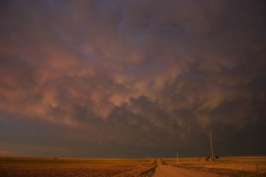
Later we caught up with a weak looking line of storms moving in from NW Nebraska ahead of the front. What a waste of time initially but we stuck around. Near McCook, NE couple of the storms went crazy for a while with unbelievable lightning display we watched from a nearby overlook. There was a wall cloud present for several minutes and during this time, from our vantage point it seemed there was a tornado but I am not certain at all. You can judge from the photographs. The lowering seemed to reach all the way to the ground but the whole thing got wrapped in rain quickly and we had to move on since the lightning went insane at the same moment. The cell passed just to the SE of McCook shortly after. I finally decided to let the now cluster of storms go and we enjoyed sunset photography - the sky just went crazy with an unreal display of color.
[attachmentid=363]
Complete page with photos at http://www.floridalightning.com/Midwest_2006.html
Martin Kucera
www.FloridaLightning.com
Left SE South Dakota at around noon (for central NE/KS border) only to regret later. As soon as we got to south central Nebraska, the Mitchell, SD cell went up and I only watched in disbelief on my Mobile Threat Net the cell being tornado warned. And I thought of staying IN Mitchell for the day. Oh well.
Later we caught up with a weak looking line of storms moving in from NW Nebraska ahead of the front. What a waste of time initially but we stuck around. Near McCook, NE couple of the storms went crazy for a while with unbelievable lightning display we watched from a nearby overlook. There was a wall cloud present for several minutes and during this time, from our vantage point it seemed there was a tornado but I am not certain at all. You can judge from the photographs. The lowering seemed to reach all the way to the ground but the whole thing got wrapped in rain quickly and we had to move on since the lightning went insane at the same moment. The cell passed just to the SE of McCook shortly after. I finally decided to let the now cluster of storms go and we enjoyed sunset photography - the sky just went crazy with an unreal display of color.
[attachmentid=363]
Complete page with photos at http://www.floridalightning.com/Midwest_2006.html
Martin Kucera
www.FloridaLightning.com
Doug_Kiesling
Left Minneapolis later then I hoped but was able to catch up to the Wessington Springs or Huron storm (nearest big city) as it moved down towards Mitchell.
The outflow in front of the storm was pretty cool with all the dust but then after some good hail, the storm just died near Mitchell. Did not get to see the tube as I was playing the wrong side of the cell thinking it would be the one lone cell that exploded... After that storm I saw a new cell back north by Watertown and the stuff to the south near Yankton. Picked the stuff to the north since I could follow it all the way home because all the storms looked as if they were not going to produce anything special.
Got up north to Watertown and the stuff I was looking at turned to junk but a new cell was getting together east of Aberdeen so I went for it.
Not long after I went after that it was tornado warned. A little more navigating and trying to find a spot and I was right in front of this dying cell. It did reform and put down a nice wall cloud with the classic box lowering and some wispy stuff that I would not call funnels. It was actually after the cell split then tried to merge with another one that was just starting that it dropped the box. About 15 minutes later it was now junk too the headed home.
The storms were cool but the best part of the chase was being attacked by half breed wolf puppies.
Yes, I said attacked by puppies... As I found the perfect spot to shoot the weak meso, across the road was a pack of puppies with their mom in the front yard. They saw me and came over to check out what I was doing. A few nips to the ankels and it was time to pack up the gear and head home.
A really poor day of chasing compared to what it looked to be forecasted. Just more upset that I missed out on some scuba diving.
On a funny note, Click Here My "Deep Thoughts" About This Year... Scuba Doug
John Hudson
EF4
Left Wiinipeg early Mon. afternoon to intercept a cell that had quickly blossomed on Environmen Canada radar, and caught up to it just north of Emerson (International Border). It displayed an okay structure, and revealed a nice shelf cloud at its base. We also spotted what we beieved to be a wall cloud, showing less than inspiring rotation.
We decided to core puch the storm, as we were more interested in the cells firing up toward Grand Forks. The core had absolutely torrential rain and was black as night, but managed to steer clear of the hail.
Upon arriving in Grand Forks, all we saw were storms congealiing into mush.We made a datastop to get an update, and saw some very small (but vigorous) cells firing down southwest of Fargo, but didn't think they'd really amount to much, so we headed back north again towards home.
Of course, we learned later that one of the smaller cells we had blown off earlier had matured to produce a weak, short-lived TOR near Leonard.
All in all, an enjoyable chase.
John
VE4 JTH[attachmentid=364]
Joe Zemek
EF2
Began chase mode in Grand Island at about 12pm and saw the earlier potential begin to dissipate. Targetted O'Neill from there and headed up 281, seeing the very distant Huron storm but thinking we would not get there in time to see anything. The NE NE area seemed to offer enough potential to stick around, so we did. The easternmost storm formed right over O'Neill and we followed it due east (!) for awhile before becoming unimpressed with it even tho it was moving into better moisture. It was nice to hear the NWS warning tone, even tho it was for quarter/golfball hail, but this day certainly more resembled its Day 2 more than its Day 1. <_<
Jimmy Deguara
EF3
Eric,
We were on the Colorado storms as well though the storms went outflow dominant. Gosh I wish I had met up.
Targetted far NW Nebraska but moved a little too late on the storm development in Colorado as it moved southeast from the Sterling vicinity. These became tornado warned in Colorado - the second of which was warned as we approached but became outflow dominant. A left moving supercell that had developed near Colorado Springs intercepted its path.
Some nice structures on a storm that followed but it never got going.

Photogenic structure:

Regards,
Jimmy Deguara
We were on the Colorado storms as well though the storms went outflow dominant. Gosh I wish I had met up.
Targetted far NW Nebraska but moved a little too late on the storm development in Colorado as it moved southeast from the Sterling vicinity. These became tornado warned in Colorado - the second of which was warned as we approached but became outflow dominant. A left moving supercell that had developed near Colorado Springs intercepted its path.
Some nice structures on a storm that followed but it never got going.
Photogenic structure:
Regards,
Jimmy Deguara