6/13/05 REPORTS: Midwest

Status
Not open for further replies.
Joined
Jun 16, 2004
Messages
430
Location
Minneapolis, MN
Well, started out from Brookings at about 4:45 and headed about 10 miles south to a cell there and watched that do completely nothing, so headed east at the mention of severe thunderstorm warnings in SW MN.

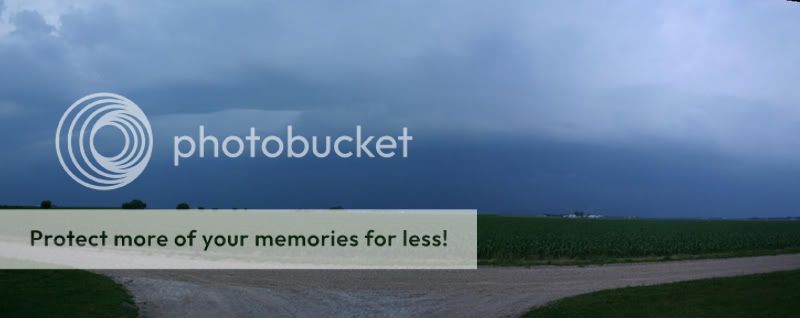
Saw these and decided it looked good to go east (there was bigger stuff to my south-east)...

Caution: I'm sorry but I don't have loads of bandwidth - stupid geocities...so if you can't get to the pic, try later. You might just want to click on the second picture I list as that's the better one.

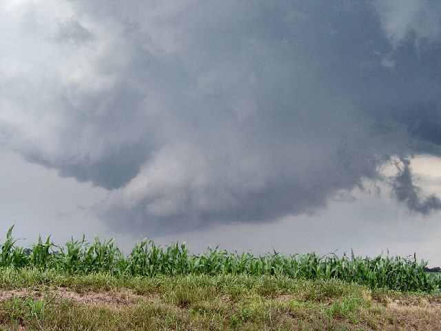
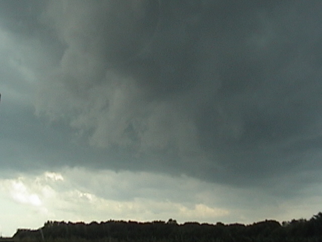
Ok, now for the baby towers:

http://www.geocities.com/Area51/Shire/8156.../babytowers.JPG

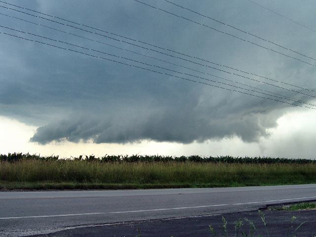
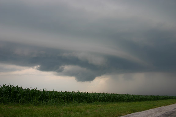
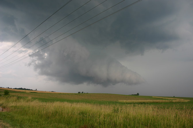
Then for the good stuff - had to get east in time to get ahead of a few storms coming out of the south in a northerly direction. Suprisingly, I didn't speed very much, if at all. Got through Tyler, MN to see a county maintainer in the direct path of the wall cloud. Thankfully at that point he was not maintaining and decided to get the heck out of there. So we pulled over at the top of a hill (mindful not to get out of the car) and watched the storm go over Tyler. The rotation was impressive. I believe just as it crossed the north end of Tyler did it give it's best.

http://www.geocities.com/Area51/Shire/8156/almost2.JPG

Was loads of fun and I'm glad we got out in time.
 
Left from Edwardsville, IL at around 3:30pm. Intercepted severe cell near Jerseyville, IL as it dropped a wall cloud and was promptly tornado warned. The base and wall cloud had visible rotation for over an hour but nothing dropped. It was still a very satisfying chase.


june1301.jpg


june1302.jpg


june1303.jpg
 
Had my best chase of the year today, and all the good stuff was within 50 miles of home. Saw a beautiful classic supercell in Jersey and Macoupin Counties, IL, including an apparent funnel cloud near Medora and the tail end of what an NWS damage survey determined to be a tornado north of Brighton. Here are a few pics:

chase61305-1.jpg

Wall cloud looking southwest from Medora; couldn't tell if the lowerings were scud fingers or funnels, but they did not persist long.

chase61305-2.jpg

Drop dead gorgeous wall cloud, looking northwest from 3 mi. south of Medora

Medoravid.jpg

This funnel cloud was reported as a tornado just south of Medora, per an update I heard on NOAA radio. Picture taken looking north from 3 mi. south of Medora. Could not confirm whether it was or was not a tornado from my location, but the NWS damage survey does not indicate any tornado at this location.

Brighton.jpg

This feature, OTOH, was associated with a tornado determined to have a half-mile damage path north of Brighton and 2 miles south of the same location where I took the picture above. I noticed violent motion, but got only about 10 seconds of video because I thought a tornado was more likely under the main meso to my north.

chase61305-3.jpg

Meso cranks up again in western Macoupin County. Taken near Shipman looking north.

After this, bailed south to escape bow echo oncoming from the next storm south, which raced across southern Macoupin Co, causing widespread wind damage. Got overrun by the south end of it and saw a few small branches fly south of Bunker Hill, but damage was much greater a few miles north of where it caught me, including the Bunker Hill area. The NWS damage survey indicates that some of this damage was caused by tornadoes that spun up along the leading edge of the bow echo, and some by straight-line winds.

Edit: A complete chase report, with additional pictures, is available at:

www.siue.edu/~jfarley/chase61305.htm

Edited 6/15/05 to reflect findings of damage survey and add picture of feature associated with the Brighton tornado.
 
My photos are of the line that formed just south of OKC, right over Norman and parts SW and NE. The line was beautiful starting, and I did chase after it down to about Noble, OK (about 5 mi south of Norman, OK) and then called it a day. Headed home and saw some of the most beautiful mammatus I have seen (although this year that has been pretty common).

http://www.vassmer.com/stormchasing/photo-...ges/2005/06-13/


Up at the lab yesterday and got bored. Watched a tower fire right over KTLX and decided that the day was slow enough to pile in a little car with 4 other people and went east. Caught the line outside of Tecumseh...drove through to the other side. Realizing we could do some good, proceeded to stay in the hail as long as possible to get sizes for the dual-pol people (our driver is their student assistant). Got 1" max...caught a couple off the car just right for a good THUNK :D

Outside of Earlsboro, saw some unfortunate motocyclist driving through the hail. I don't think his rain poncho helped.

The line continued east and we called it a day. All in all, good fun.
 
Saw the same cell as Skip and John, though I don't think I saw either Skip or John. Noted a tornado report in the SPC log - presumably associated with the same cell - but I was in the area and never saw anything beyond a persistent wall cloud, with occasional broad rotation. Surface inflow became progressively weaker, along with a number of smaller cells eventually raining into the inflow region, and with time a squall line overcame the cell and that was the end. I wasn't disappointed though given my expectations for the day. At least the cell motion was quite reasonable - and the storm had decent supercell structure at times.

Glen
 
06/13/05 Iowa

Weather phenomena witnessed:
A. 1 Shelf cloud (Boone County)
B. Winds gusting between 50 and 60 mph (Marshall County)
C. Possible wall cloud (Marshall County)
D. Intense CG lightning (Marshall County)
E. Hail-Maximum approximate size- .70 inches in diameter (Marshall County)
F. Very heavy rain (Marshall County)
 
I stayed East off the cells in West central Iowa waiting for one to become dominant. That never happened. I finally decided to move West to get a look at the storms to see if they had very good structure. I watched the strongest cell create a big dust wave along its gust front. I moved South after this and stopped on the South side of Desmoines. This is when the tornado warning was issued for the storm that was about 40 miles South of me. It didn't look good on radar and I had been driving for 36 hours straight if you don't count my 2 hour stop in Wichita to drop off video and resupply at my house. I decided that I was to worn out and needed some sleep, so I went and got a hotel room instead. I later found out that the storm produced 3 tornadoes. I wasn't too upset about not going after the storm. I was just happy not to fall asleep on the road after driving all night. It isn't hard to deal with a bust after seeing the Kent county storm the day before.
 
Well it wasn't totally a chase, more of a spot, but I went westward to the Illinois/Indiana border and watched the squall come through. Got some pretty nice wind gusts, lots of CG, rain, and some hail, but nothing to amount to anything. All in all it was what I expected from the usual squall around here.

squall3.jpg


tonight.jpg


pano.jpg
 
Rolla, MO supercell and funnels-
Wasn't planning to chase on Monday, as I had to make it back to Charleston for a 10AM meeting on Tuesday. However, a supercell exploded right on I-44 in front of me and tracked along the interstate, giving me an easy and unexpected chase!

The supercell developed southwest of Rolla, and the meso stayed pretty much right over, or just south of, I-44 for most of its life. The storm had a large rain-free base and strong inflow features curving in. A wall cloud quickly developed with strong RFD slots developing off and on. Saw several persistent funnels and heard the sirens going off in downtown Rolla.

Click photos to enlarge:


I left Yorkville in the late afternoon with the intention on intercepting the Peoria supercell near Interstate 57. Since I do not have access to radar in my car, once I leave, it becomes a crap shoot. I actually did pretty good, except that storm lost it's intensity and storms reformed south of Lexington. Once I realized this, I hauled A south and east. I was on the north side of the squall line and got into some pretty good wind and lightning but no hail. I got some good video and pictures for my students next year. I have had a couple of close calls with lightning this year though and have become a little concerned.
 
Excellent Photos!

Mike,

Those are some nice shots!

I spotted a few chaser vehicles on I-35 in Des Moines. We were all watching a cell approaching Clive. Didn't really see much except dime size hail and some suspicious lowering. Anway, I'm glad you got some photos of the cell near Pella.

Thanks for sharing.
Cindy
 
Status
Not open for further replies.
Back
Top