Sam Hall
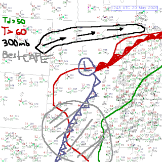
Yes, agreed, for tomorrow any storms that do develop will be high based due to the moisture/temperature situation. It's not a great dryline at all, for a good dryline I'd want no moisture almost to the W (maybe 20s/30s) and 60s or so to the immediate E LOL! A dryline is similar to a cold front in that it lifts the air ahead of it aiding the growth of thunderstorms and I feel it will be interesting that an additional cold front will be moving perpendicular (sort of) to the slight dryline tomorrow... but as Jason says above (just noticed your post, Jason, hence my edit here lol) I, too, would look towards the more experienced here for confirmation and info... and also observe what actually happens tomorrow!
But, wind profiles are much nicer, so could support rotation in storms that develop. Today the cap was just ridiculous and any radar echoes that developed near the mountains in MT died off as they passed the hills, presumably again due to the lack of moisture and forcing to keep the cumuli growing.
700 mb temps a bit better tomorrow, ETA progging 10 C or so, still with good surface temps and winds we have a better chance of something popping through, and a CIN hole in central/western areas of NE. So, North Platte and around - maybe towards Scottsbluff is my current feeling for a target tomorrow. We are currently in Valentine, NE.
I am still learning after 5 years of chasing too Neil, so even though when stuff doesn't happen, I am very interested to learn the reasons and improve my forecasting targets for the subsequent chase-years Currently, I am interested in thinking about what will happen when the cold front intersects the slight dryline. Maybe the 'dryline' is not defined enough to do anything, but I wondered whether it may cause some instability with moisture converging from the cooler air behind the front and slightly moist, hot air infront...
Anyway on to tomorrow!!!
But, wind profiles are much nicer, so could support rotation in storms that develop. Today the cap was just ridiculous and any radar echoes that developed near the mountains in MT died off as they passed the hills, presumably again due to the lack of moisture and forcing to keep the cumuli growing.
700 mb temps a bit better tomorrow, ETA progging 10 C or so, still with good surface temps and winds we have a better chance of something popping through, and a CIN hole in central/western areas of NE. So, North Platte and around - maybe towards Scottsbluff is my current feeling for a target tomorrow. We are currently in Valentine, NE.
I am still learning after 5 years of chasing too Neil, so even though when stuff doesn't happen, I am very interested to learn the reasons and improve my forecasting targets for the subsequent chase-years
Anyway on to tomorrow!!!
Last edited by a moderator:


