Skip Talbot
EF5
I thought some of you might find this interesting:

We had a cold air event yesterday that spawned clusters of thunderstorms. This storm was one of the stronger ones that came out of Wisconsin and appeared to develop a hook echo over the northern suburbs. I dismissed it as coincidence at first, thinking it was just a smaller cell on the southern flank. The feature persisted, however, and then registered a meso marker as well. It appears that this severe storm was able to go supercellular once it hit the lake breeze boundary. Notice the 180 degree shift in the wind readings from the surface stations. The storm produced a few damaging straight line wind reports including downed power poles.
We had a cold air event yesterday that spawned clusters of thunderstorms. This storm was one of the stronger ones that came out of Wisconsin and appeared to develop a hook echo over the northern suburbs. I dismissed it as coincidence at first, thinking it was just a smaller cell on the southern flank. The feature persisted, however, and then registered a meso marker as well. It appears that this severe storm was able to go supercellular once it hit the lake breeze boundary. Notice the 180 degree shift in the wind readings from the surface stations. The storm produced a few damaging straight line wind reports including downed power poles.
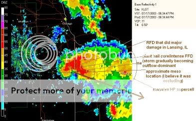
 I was sitting in a van in my driveway when the tennis-ball-sized hail and 90-100MPH hit.