• While Stormtrack has discontinued its hosting of SpotterNetwork support on the forums, keep in mind that support for SpotterNetwork issues is available by emailing [email protected].

4/27/2017 Tornado Reports Question

Joined
Feb 4, 2012
Messages
70
Location
Massachusetts
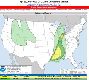
I noticed on the SPC tornado reports log, they listed two separate reports tornados in Western Kansas. Looking at the SPC convective outlook and the tornado reports validated with their risk area, it doesn't appear to support even a long shot chance of tornados appearing in Western Kansas that day. So what gives?

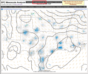
I have several questions as to not only why this is, but how would i review data from 2/27 that could have hinted at the possibility there was going to be possible convection appearing in western kansas that particular day? Did the data suggest there was a chance of a tornado to occur in Western Kansas, and the SPC simply did not focus there? I'm, not trying to second guess SPC, i'll leave that to those who know what they're doing, but i'd like to somehow learn more. Perhaps there is nothing to learn here, and it was a freak event, but i'd like to try and learn from this whenever possible. Thanks in advance for any direction someone can give me.


upload_2017-4-28_12-49-53.png
 

Attachments

  • upload_2017-4-28_12-39-42.png
    upload_2017-4-28_12-39-42.png
    80.3 KB · Views: 2
I think the tornadoes are a bit in dispute. They were called in by a storm chaser/fire department personnel, but the pictures i've seen look more like rainshafts and perhaps a downburst.
 
The SPC did have that area in a marginal risk:
day1otlk_20170427_2000_prt.gif

They also has it in a 5% wind and 5% hail area: http://www.spc.noaa.gov/products/outlook/archive/2017/day1otlk_20170427_2000.html. Given the wind and hail risk, my guess is they thought wind shear was lacking or the wind profile was non-ideal for a TOR risk. Assuming a recent nearby observed sounding isn't available surface observations and a nearby radar's Vertical Wind Profile (VWP) can help you tell it the risk for a TOR is increasing.

It is important to remember that not having a TOR risk area doesn't mean the risk is zero. They just thought it was less than 2% chance with 25 miles. Similarly, you will often see severe thunderstorm watches and warnings that include the wording "severe thunderstorms can produce tornadoes with no advance warning" - just because you don't get a tornado watch doesn't mean the risk is zero.
 
Wow, I can't believe there's a thread for this! I love it! I actually saw this storm develop from nothing in E CO. After a little while it was a low-topped updraft over the CO-KS state line with extreme tilt. It only rose from its base a couple thousand feet before laying over nearly horizontal, but it would not quit. I never considered chasing it because it was a cool day. I think the temps were in the low 60's.

I was talking to chaser friends from Albuquerque enroute to Amarillo, and mentioned seeing a lightning bolt from this thing. I don't doubt that it produced a tornado, because I have seen tornadoes in the most unlikely parameters, including one on April 12. I shot a short vid of that one, which the Pueblo NWSFO is apparently now using for spotter classes.

Oh, BTW, the Td's were in the 40's in W KS yesterday.
 
For one thing, keep in mind that the SPC reports page only shows events for which an NWS office issued a Local Storm Report (LSR). That doesn't mean the report will end up in Storm Data as an official tornado, as Storm Data is higher quality information that is post-processed and QC'd compared to initial LSRs. If an office does a damage survey, for example, the results from the damage survey will be what is published in Storm Data rather than the LSRs from the event. The GLD and DDC offices will probably go back and check whether or not these could have been legit tornadoes. If there is not sufficient evidence, they will not submit the reports for publication in Storm Data.

Meanwhile, there are a few quick and easy ways to examine past severe weather environments. If the event is less than about 36 hours old, you can view zoomed-in sector environmental information just as you could in real time by clicking on the "image archive & loops" button on the SPC mesoanalysis page (see illustration). If the event is further in the past than that, you can still look at archived mesoanalysis images, but only on the national sector. Those images are located at http://www.spc.noaa.gov/exper/ma_archive/images_s4/ (can also be found by clicking on the link near the top of the main SPC mesoanalysis page: http://www.spc.noaa.gov/exper/mesoanalysis/).
 

Attachments

  • example.png
    example.png
    207.8 KB · Views: 2
For one thing, keep in mind that the SPC reports page only shows events for which an NWS office issued a Local Storm Report (LSR). That doesn't mean the report will end up in Storm Data as an official tornado, as Storm Data is higher quality information that is post-processed and QC'd compared to initial LSRs. If an office does a damage survey, for example, the results from the damage survey will be what is published in Storm Data rather than the LSRs from the event. The GLD and DDC offices will probably go back and check whether or not these could have been legit tornadoes. If there is not sufficient evidence, they will not submit the reports for publication in Storm Data.

Meanwhile, there are a few quick and easy ways to examine past severe weather environments. If the event is less than about 36 hours old, you can view zoomed-in sector environmental information just as you could in real time by clicking on the "image archive & loops" button on the SPC mesoanalysis page (see illustration). If the event is further in the past than that, you can still look at archived mesoanalysis images, but only on the national sector. Those images are located at http://www.spc.noaa.gov/exper/ma_archive/images_s4/ (can also be found by clicking on the link near the top of the main SPC mesoanalysis page: http://www.spc.noaa.gov/exper/mesoanalysis/).
Thanks Jeff this is super helpful!
 
Back
Top