• While Stormtrack has discontinued its hosting of SpotterNetwork support on the forums, keep in mind that support for SpotterNetwork issues is available by emailing [email protected].

4/21/07 REPORTS: TX / KS / NE / CO

Hi Dick,

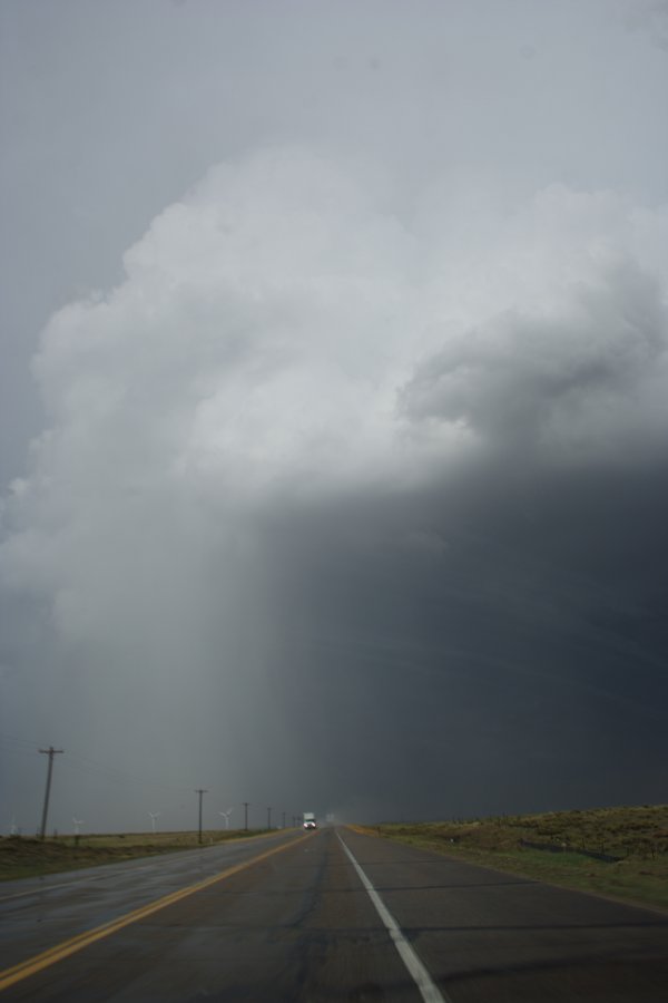
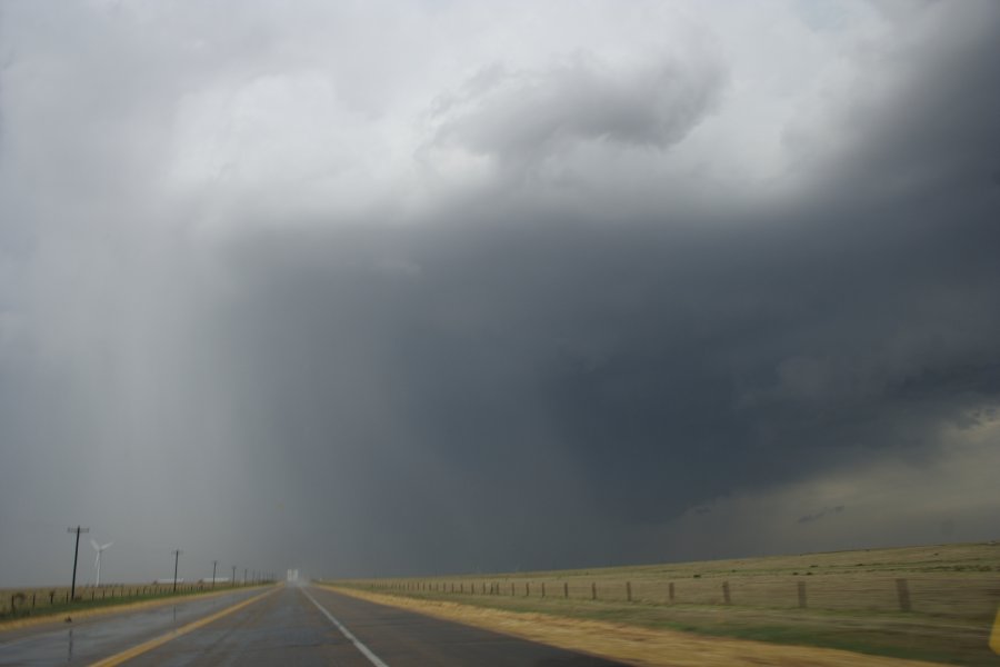
I passed this from the northern side - got a some good hail too. I have timelapse as it developed to my W and SW - were you south of Granada?

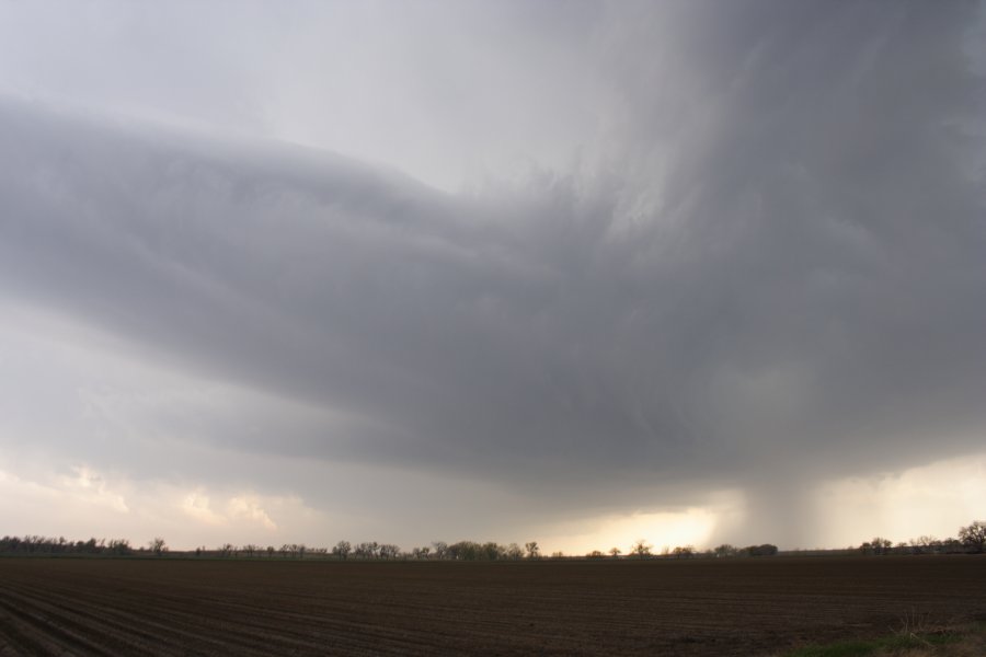
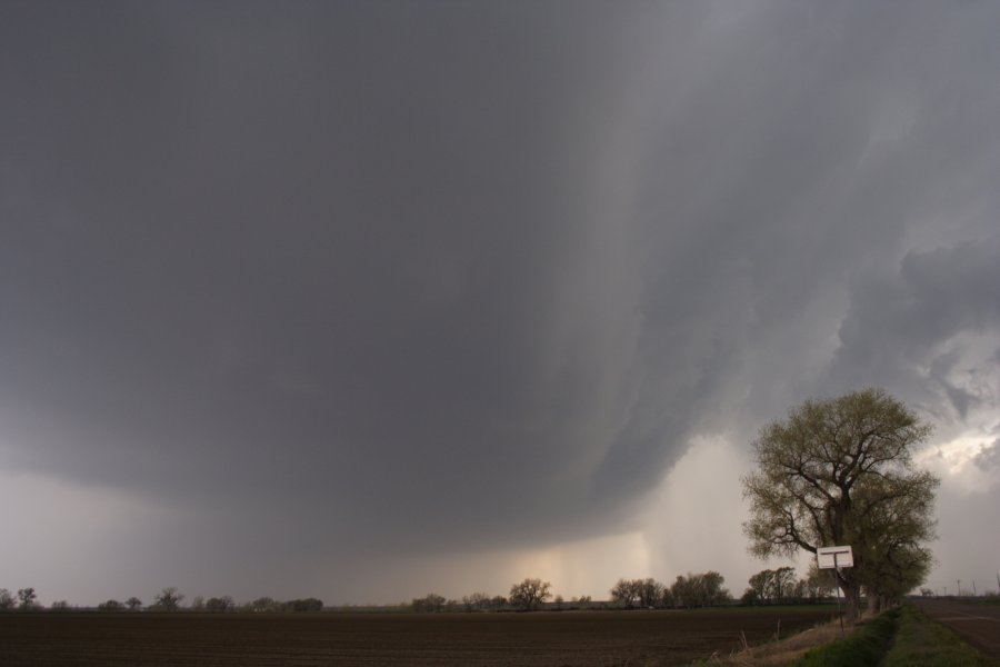
Did you see the second supercell that developed - perhaps exploded behind this? Actually it could be on the back end of the last photograph. That was the large tornado producer.

Regards,

Jimmy Deguara
 
Hi Jimmy,

From what Dick told me on the phone a couple of minutes ago, you were in the red van and we would have been in almost the same exact location as you when this was taken on the second supercell that formed southwest of Granada.

0421071.jpg
 
Last edited by a moderator:
I left Dallas around 8:30AM and headed for my initial target around Lubbock, Texas. I went West on I-20 past Abilene and then North towards Lubbock on 84. I arrived in Lubbock around 1:30PM and gathered data while grabbing a quick bite to eat. I shifted my target a little and continued North on 27 towards Plainview. I traveled North and eventually got to Tulia, Texas. I met with a few other chasers and sat on the Western side of Tulia watching the dryline move East. While watching the dryline, I poured over some data and got some nowcasting from my Friends Jeremy Wilson and Aaron Hughes. Storms began to fire to our Southwest so I, along with a female friend we met at our observation point, blasted West on 86 towards Dimmit to try to intercept the now rotating storm. As we passed through Nazareth, Mobile Threat Net radar was showing incredible shear on our storm. We went North on 385 and intercepted the storm near Hereford, TX. The storm now had a Tornado Warning on it and had great structure. We pulled to the side of the road and watched the storm develop a wall cloud. About a minute later a very raggedy looking funnel dropped, and we watched Tornado number 1 for the day move slowly to our North. We took some photos and video, then continued to chase the tornado until it disappeared into a rain and hail core. We began to get quarter sized hail, and our route to follow the storm turned into a very muddy 1 lane road. Before we got stuck, I kicked on the 4x4 and we turned around and got back to paved road. At this time the tornado turned into a very large cone, but we were blinded by the core and had no road options. We went back North and eventually made it to US60 and made our way towards Canyon, Texas. At this time a very large "wedge" tornado was being reported near Tulia. We raced Southeast and made it to Ranch Road 2698, which is a few minutes north of downtown Tulia, as the Tulia tornado and its core passed in front of us through town. We parked near an overpass in the grass while golfball hail fell and the tornado passed in front of us. The core of the storm passed to our East and we got back onto the highway and continued South to attempt to find an exit to turn around and go back North on 27. We found the exit and went back Northbound where we passed the tornado debris path. We exited 2698 and went East past Tulia after the Tornado had hit town. On 2698, our route was once again blocked by power lines and poles crossing the road. At this time it was getting dark, and we would be unable to keep up with the Tulia tornado. We turned around and went back South on 27 out of Tulia. A new area of rotation formed to the Southwest of Tulia, just to our West. We pulled over and watched it for a few minutes. The storm went tornado warned as it went to our Northwest and dropped a cone tornado. This storm had a very well defined hook on radar. We observed tornado number 2 just NW of Plainview for about 10 minutes before it disappeared as well. At this time we called it the end of the day and got dinner in Plainview before heading back towards Dallas. Sorry about the large picture, I don't know how to make it a thumbnail or smaller within the StormTrack Forum. I will upload more photos to my website later tonight after work at > www.stormpursuit.com/2007documents.htm

Picture0201.jpg

041420073.jpg
 
Last edited by a moderator:
Just curious..

Did anyone happen to get video or take a picture of the tornado that crossed I40 west of Amarillo at about 7PM?
 
What tornado, and what mile marker (approx)?

I really don't know to be honest. It was at about 7:30PM about 5-6 miles west of Amarillo in the southweest part of Potter County, my chase partner and I actually got caught in the tornado's circulation. Mike Scantlin, fellow ST member, was with us and got a picture of the tornado..

Wish I had more details such as mile marker.
 
4/21/07

Chased with Bill Tabor and Gene Moore today. We saw 3-4 Tornadoes in total. See Bill's description for more information. Here are a few quick pictures. In the last picture, notice the power lines down on the road. The photo was taken from the tornado track. At this point we were just south of Olton. After dark we saw a tornado East of 27 at the Happy intersection. We first saw this tornado at 8:57. We all saw this visually and Gene caught this on his video camera.
 

Attachments

  • DSC_0062_resize.JPG
    DSC_0062_resize.JPG
    96.7 KB · Views: 86
  • DSC_0159_resize.JPG
    DSC_0159_resize.JPG
    81.5 KB · Views: 80
  • DSC_0049.JPG
    DSC_0049.JPG
    96.8 KB · Views: 87
Last edited by a moderator:
The Tornadojunkies team made the trip down to Texas from Manhattan... We camped East of Amarillo (...or Amadillo as all the truckers call it) about a half an hour at a Love's. We were there for most of the afternoon and talked to quite a few other chasers that stopped by.

When storms started to fire to the West we headed out and got on the cell that eventually produced the Dumas tornado. We followed it North for a ways and then decided to drop back towards Amarillo and get on a more southern cell. Unfortunately we missed out on the tornado in Dumas, although we did get quite a good show from the cell while we followed it. We drove through nickel/quarter size hail on the Interstate and eventually headed North towards Dumas. We arrived just after it got dark and the Entire town was out of power. It was a pretty surreal scenario...

All in all, a pretty good chase day...if a bit frustrating. We should of stayed with the cell we were originally on but we didn't, I guess it's just another lesson learned.

I'm looking forward to tomorrow... Finally a close to home chase day, and quite a good day it is shaping up to be! It'll be nice not to have to dread an 8+ hour drive home for once. Plus, the roads up here in Kansas are a million times better than Nebraska and Texas.

Here are a few photos:

The storm that eventually went on to produce the Dumas tornado. This was just North of the interstate a few miles.

IMG_7413.jpg


This was looking South from the same spot. We saw a looot of rotation going on.

IMG_7433.jpg


Further up the road a little ways we encountered a power line that was on fire:

IMG_7455.jpg
 
Doug Black and I picked up the storm as it arrived in Hereford. We stayed ahead of it up to and through Wildorado then over to Bushland. Like a lot of people, we saw the brief tornado north-northwest of Bushland. We dashed north and then northeast to get to the Loop (335) to pick up the Dumas Highway (87/287). We got to around Masterson and by then, the storm was getting much more organized with a lot lower base. By the time we got to Four Way (Hwy 87/287, 354, and 1913 junction), the storm was very well defined and we were still in a great position to keep an eye on the wall cloud. A small jog down 1913 put us in the perfect spot to watch the several small tornadoes form including twins and a multiple-vortex phase. We had to go farther east becase the rain and hail quickly wrapped in behind the tornado. The tornado increased in strength rapidly from there become a well-defined wedge with a serpentine funnel forming from the right side of the wedge at one point. We had to try to keep up with it, but the roads weren't favorable. So by the time we caught back up to it, it was back to just a well-defined mesocyclone. We saw one more tornado in the dark light up by lightning.
Overall, it was a tough chase day, but a very rewarding one as I got the chance to see the largest tornado I've ever witnessed. Video taken by Doug...screen caps of that video shown below
1033041.jpg


1033042.jpg


1033043.jpg


1033044.jpg

 
Last edited by a moderator:
My wife and chase partner Lori and I and the Santa Fe Chase left from NM at 8am. After some discussion we decided to head to Amarillo instead of our initial target of Plainview.

We hung out in the Barnes & Noble parking lot in west Amarillo looking at data.


Tornado #1
The first tornado occurred jus north of Vega. We were a ways from it. It was a nice elephant trunk. Unfortunately our picture didn’t turn out. We had to backtrack as our east /west road options were going to run out before we intercepted the cell.

Tornado #2
This tornado was so large we didn’t realize we were looking at it. We were south of Dumas looking west. I believe this may have been wedge in Channing.

dumas1.jpg


dumas2.jpg


Tornado 3, 4, and 5
We observed these tornadoes just west of Dumas on highway 87. As we arrived a funnel was just starting to form to the southwest.

dumas3.jpg
dumas4.jpg


As we were looking to our south one of our crew pointed out the well defined elephant trunk tornado just to the north.

dumas5.jpg


As the southern funnel touched down we were watching two tornadoes on the ground simultaneously.

dumas6.jpg


The southern funnel lifted and soon after another tornado touched down much closer to us (likely the same tornado recycling). The other tornado remained on the ground all this time appearing not to move at all. At one point it grew larger and threw out lots of debris before it became a rope.

dumas7.jpg


dumas8.jpg


The tornado crossed the road in front of us, taking out the power lines as it did, and quickly became a very large stovepipe.


dumas9.jpg


dumas11.jpg


We attempted to chase them further north but the police closed the road ahead of us and by the time we got further northeast it was dark.

As we headed towards Stratford it became evident that the power was out in virtually every town in the area. We ended up having to drive about 100 miles back to Amarillo.

We owe a great deal to Rich Hamel for nowcasting and and to all the posters here.

What a day!
 
Last edited by a moderator:
Here's a still of the Channing tornado, viewed from the northeast, and another of the (eventual) Cactus tornado just after it touched down southwest of Dumas (also viewed from the northeast). Wish we more/better stills, but there was too much lightning/light precip as we viewed the Channing wedge to get out of the car, and it was too fast-paced a chase to really get any good stills after that. We did get good video, though, except for a lens cap problem when we had dual-tornadoes after dark on the third storm we intercepted near Sunray. :p

05FirstTornadoOfTheDay.jpg


10Tornado2.jpg
 
After reviewing Verne/Michael Carlson's images and one of Chad Lawson's, I now realize there were TWO tornadoes east of Channing simultaneously; the teardrop-shaped one I saw initially with a lightning strike and a large wedge.....we saw the wedge later on in its life northeast of Channing, and assumed it was the teardrop tornado from earlier.....but now I realize these were two different tornadoes. Cool, that makes a lucky 7 for this day now :D
 
After reviewing Verne/Michael Carlson's images and one of Chad Lawson's, I now realize there were TWO tornadoes east of Channing simultaneously; the teardrop-shaped one I saw initially with a lightning strike and a large wedge.....we saw the wedge later on in its life northeast of Channing, and assumed it was the teardrop tornado from earlier.....but now I realize these were two different tornadoes. Cool, that makes a lucky 7 for this day now :D

Here is the image Shane is talking about. 10 ENE of Channing, TX
http://www.mesomick.com/pages/images/chase/04212007/ChadLawsonApril212007TXPAN.jpg

Of course by looking at this vidio capture it looks as if there are THREE tornadoes at the same time. :confused: :eek:


Mick
 
Last edited by a moderator:
Back
Top