4/16/06 REPORTS: IN/IL

Raymond wade

After eating dinner decided to head north of indy for a severe warned cell in cllinton county. Didnt have real high hopes for it as it was linear in shape to start but then got its act together. It was moving at 35mph to the east and then it seems like it just stopped. I dont know if it was trying to get on the warm front or what but it sat in one place for about an hour and then took off to the northeast again. Witness a funnel with possible tornado and decent structure for it being overcast.
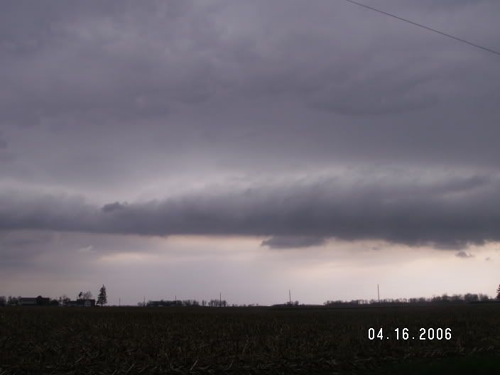
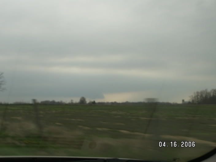
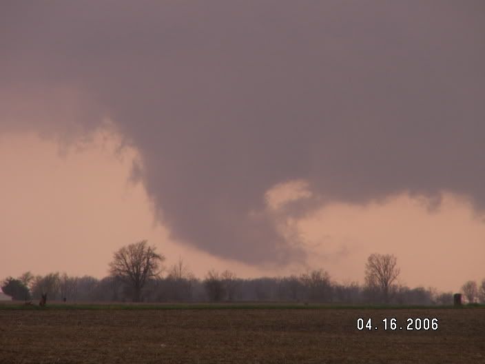
This pic was just before boxley.


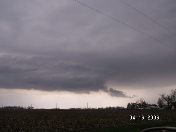
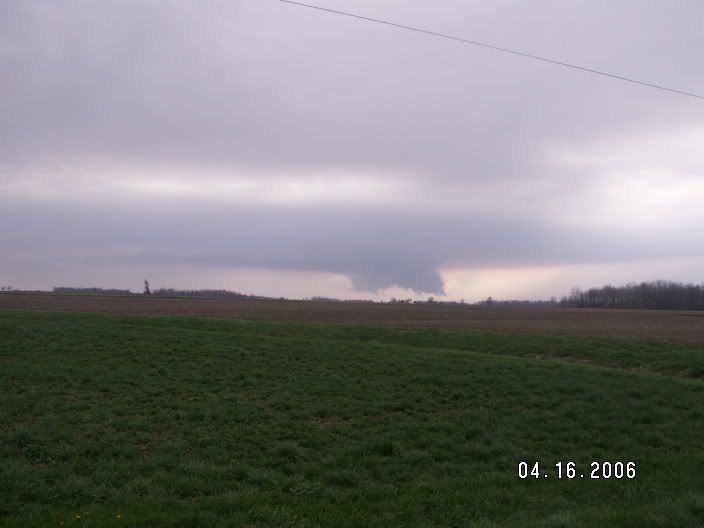
Now sitting southeast of the storm.


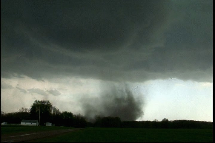
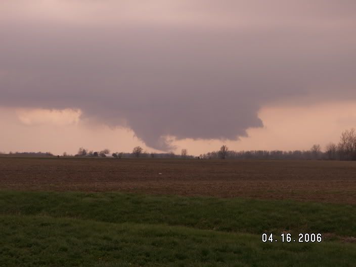
Possible tornado(but could not see ground level due to trees). Rotation was very visible though.


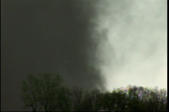
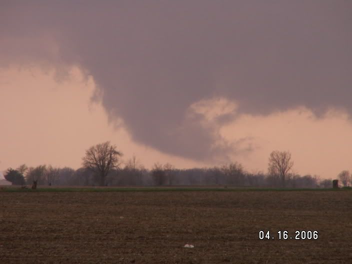
After that it, was torn apart by the outflow of the storm and began moving to the north northeast.
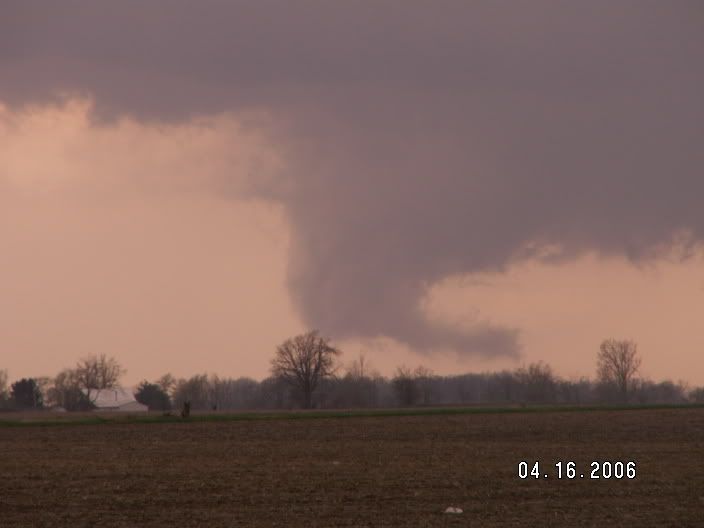
 
Based on repeated estimates from SPC on E IL/W IN having higher favorabilities we chose to head west on I70 at 4:00p.m. to intercept the southernmost cell coming out of IL. A full report with more images is available at http://www.wrathofnature.com/phpBB2/viewtopic.php?t=18
Today we positioned ourselves almost perfectly, something we're not used to being able to do in Central IN with so many hills, trees, houses, etc. This cell was tornado warned through numerous counties.

Nice Mammatus of the approaching storm


Lucky lightning grab with heavy precip, possibly some hail in here. Facing north.


As far as we could tell, this lowering was not on the ground. This storm had some of the best rotation we have ever seen.


The lower lefthand portion of the next few images is the tornado, it appears to be on the ground but there is no complete visible connection here.


We continued to travel south as it felt like it was changing directions a little and sure enough we came upon what looks like a really weak tornado on the ground kicking up dust and debris. Behind the fencerow in this image a wall of dust can be seen. At this point we felt it was not safe to be where we were and hauled south to make absolutely sure we were out of its path, the alternative would be to head north into the core.


After playing it safe we caught a couple more nice images as it gradually lost its strength and became consumed in the approaching line.


I chased the supercell that took aim at Bloomington. Gave up soon thereafter as convection was ongoing just about everywhere and I did not have the time/money to go flying off to southeast Illinois. A few pics and brief report here: http://chubasco.niu.edu/chase/060416.htm

IMG_0027_sm.JPG


Thanks to Josh Durkee for the nowcasting support.

Simon, looking forward to the pics. Congrats.
 
Excellent day today in East Central Illinois. Got 2 tornadoes, excellent video of the first one. It was the best Easter I've ever had!

Today’s chase began around 2:00 when I left my Grandparents Easter dinner in Sullivan, IL. I headed north to Cerro Gordo and waited for a tornado warned storm to move through the area. I positioned myself on the southern end, but it was hopelessly high precipitation. There was no way to view any type of clouds inside the very heavy rain. I moved north from Cerro Gordo then east on I-72 to catch back up to the storm. I was rarely able to see any clouds through the heavy rain.

After screwing around in rain only, I decided to head back to Mattoon to analyze the weather situation. There were several times on I-57 where traffic was completely stopped. Each highway overpass was down to almost 1 lane due to the large number of people seeking shelter under them. When I was about 5 miles north of Mattoon I could see a rain free storm base with small but persistent wall cloud. I exited I-57 at Mattoon and traveled north on route 45 and stopped around 1100 N. At this point it was clear that things were starting to happen. The wall cloud had been there for a while and was showing clear signs of rotation. I could see that an RFD was blasting down and kicking up dust. These were all good signs! During this time I was reporting my observations to the spotter net which was relaying them to the Coles County EMA and NWS ILX. I then jumped back on 45 and drove north. Things were really starting to happen now, the wall cloud was unmistakable. It was clearly rotating as it moved over or just south of Humboldt.

Shortly after it moved over Humboldt a nice cone shaped funnel appeared out of the wall cloud. Everything was coming together; there was a clear slot on the back of the wall where the RFD was punching down. A long, curved inflow band extended from just above the base of the wall cloud. Dust was visible from both the inflow region and RFD region. The funnel cloud touched down just before I-57 and moved over the interstate. The condensation funnel wasn’t down yet, but there was obvious circulation on the ground and a debris field. I have the tornado moving over the interstate on video. I wasn’t close enough to see if any cars or tractors were hit, but I’m sure somebody had a close call due to the high traffic on Easter.

At this point I was loosing contrast and was barely able to see the tornado. I had to push south 2 miles to cross I-57. I then traveled east and witnessed a beautiful tornado. It was cone shape and the condensation funnel extended to the ground. There was a debris field rotating quickly around the tornado. I drove north and stopped about ½ mile south of the tornado and watched it move through a field. From my vantage point it appeared to directly hit a farm. Obviously the tornado wasn’t very strong because all trees and buildings were left standing. Shortly after hitting the farm the tornado roped out and returned to the clouds.

The second tornado became visible not more than 2 or 3 minutes after the first one. It was about 4 miles north of the last tornado and appeared much larger and more dangerous. I traveled north to get closer to the tornado for a better view. I can confirm that this tornado was on the ground, but it was very brief. Probably less than 1 minute. There was a debris field, but the condensation funnel never touched fully. Since I saw circulation on the ground that means it was a tornado. This tornado displayed some very rapid rotation, much more than the first. It dissipated and lifted back into the wall cloud.

I was able to keep up with the wall cloud region of this supercell for about 1 hour and 30 minutes as it produced several other quickly rotating wall clouds. To my knowledge, the storm did not produce any other tornadoes. I called the chase around 6:30 and headed back to home.

My tornado footage was the top story on WAND TV at 10:00.

t1-1.jpg


t1-2.jpg


t1-3.jpg


t2-1.jpg


t2-3.jpg


I have more pictures and videos on my chase log.

http://www.brademel.com/pages/storm_chase_...php?year=&id=17

Still uploading the videos, they will be linked soon.

EDIT: Videos uploaded
 
I was driving back from Grandparents house on SR28 going west when I unintentionally ran into the Tornado wanred storm North of Indianapolis and very near Frankfort. The storm NEVER produced a tornado and never had any major rotation, but the wall cloud was very low and impressive in appearance. I have one image worthy of posting and thats it for this "chase day". Went on to the west after the cloud lost it's impressiveness and never saw anything more than a weak squall line segment between Attica and Lafayette, IN.

Images taken just south of the small town of Kempton, IN.

Wednesday should be interesting though...

Terrence Cook
 
Left home around 1pm for chasing along the I-70 area in Illinois.Intrcepted the storm that was moving into Fayette county near Bingham to Ramsey.Had a nice lowering west of Bingham and followed it into Ramsey at which time it produced a brief funnel northeast of Ramsey.After that headed back down to I-70 and intercepted the cell moving east towards Vandalia.As the storm passed just north of Vandalia it had a some nice rotation and thought it would drop a tornado at any time.Followed the storm all the way to just south of Effingham when i made a fatal mistake on road network to take.The storm produced a tornado near Dieterich and Wheller along hwy 33 southeast of Effingham.Do to my mistake earlier i missed the tornado bye minutes as i approached it again from the south.I heard reports that it was a large tornado at one point.Being frustrated for following the storm for so long then missing the show i headed back towards St.Louis as the storm headed from Jasper county into Crawford county.Overall was a good day but also very frustrating at the same time.
 
I got a short look at the tornado SE of Effingham, IL just after 5 p.m. yesterday - unfortunately I was trying to get through town at the time when it occurred, so was unable to get video or even a long, clear view of the tornado, but at least I saw it. Not sure whether my one quick attempt to get a pic was successful or not. The intensification of this storm was something to see - rock hard updraft towers over a wall cloud that grew tight and round, then the tornado came down. You could just tell from the process beforehand that this storm was about to produce. By the time I got through town and had a clear view, the area of interest had become hidden behind wrapping precipitation. I followed the storm to Robinson and saw a lot of interesting lowerings but nothing I would definitively classify as a funnel or tornado. Most of the time, my view was restricted by wrapping rain and/or scud and gunge. I wish I had been east of this storm instead of west of it.

Earlier, I caught a very nice rotating wall cloud and RFD notch, along with possibly a couple gustnadoes or brief spinups, a few miles WNW of Assumption, IL. This was probably the same meso that shortly later produced a tornado 7 miles north of Assumption, but before that happened, a storm from the south merged in and eliminated any view I had of the area of interest - plus forcing me to run east to avoid getting cored.

EDIT - 4/19/06: I have now posted a full report and a number of pictures. You can view the report and pictures at:

http://www.siue.edu/~jfarley/chase41606.htm

EDIT #2 - 4/20/06: UPDATE - after posting this report, I had email communication with Dave Hoadley, who followed a general route similar to mine and observed the spinup feature I saw west of Assumption, but from a shorter distance and from the opposite side. He confirms that it was a tornado, albeit a brief, weak one, since he observed rotation both in the dust and in the clouds above it. The report linked above has been updated accordingly.
 
Hi guys - first post and I caught some cool storms yesterday.

The first storm (LIV photos) I intercepted was in northern Livingston County, about 6 miles SE of Streator, IL. This storm rapidly developed around 3:00 pm and exhibited briefly strong inflow (inflow winds peaked at 25 mph <5 minutes) and some rotation, but then somewhat fell apart. It did produce pea to nickle size hail and torrential rains of up to 5 inches in some parts of southern and eastern La Salle County. There were significant flash flooding problems last night near the Streator and Ransom areas, although I was unable to get any good photos of the floodwaters due to the darkness.

The second storm (LAS photos) I intercepted was coming out of eastern Bureau/Putnam County near La Salle-Peru, IL. These photos were taken around 6:00 PM at the I-39/IL Rt. 71 interchange looking northwest towards Spring Valley, IL. This storm had strong inflow for about ten minutes (peak inflow winds recorded at 29.3 MPH) and exhibited rotation, although not strong/violent and not so well organized. This storm did produce torrential rains, hail and even some minor wind damage near Utica, IL. Not the greatest chase day, but cool storms nonetheless.

Jesse
 
Finally have a chance to report my chase from Sunday. I left a family gathering in the Metro-East (Illinois side of St. Louis) at about 3pm and headed east on Rt 50. I paralleled a supercell, that was basically following I-70, from the south side for several miles until a reached I-57 and Salem, IL, where I picked up my navigator/photographer/girlfriend, Tracy Sinclair. We headed north on I-57 to hopefully intercept the storm near Effingham. A few miles south of Effingham we could see an RFD notch and possible wall cloud on this cell. We got off of I-57 at the Watson exit south of Effingham to observe the storm, which now had a large rotating base. The NWS soon reported that a tornado had been spotted 1 mile south of Watson, which was exactly were we at, but we did not see it. We then headed east on 700N following the storm. We passed north of Elliottstown and south of Dieterich, and saw a couple of houses with their roofs blown off and several trees down. We were apparently just behind the tornado, but I don't believe we ever saw it. We got on Rt 33 and followed it east to Oblong in Jasper Co where there was another report of a tornado. That was where we ended our chase. We did see several possible funnels, but nothing that we could confirm. I have tried to add a few pictures of the chase. I wish we could have started the chase a little earlier, but we had some family obligations on this holiday. The last I heard, no one was injured in the damaged homes. This was a good chase with short notice. [attachmentid=168][attachmentid=169][attachmentid=170]
 
still2.jpg

still10.jpg

still4.jpg


Pretty intense day us (Simon Brewer, Lela Knight, and Shawn Maroney):

Got 4-5 tornadoes......one was on the ground for quite a while in Southeastern IL.

Was SSW of Effingham, IL when we intercepted a violently rotating wall cloud, which produced a dusty tornado about a quarter-mile to our WSW. The tornado tracked slightly south of due east and passed to our south with an incredible view: a large brown debris cloud with a slender cone funnel diving into it.

Finally got a chase page up for Sunday:

April 16th, 2006 Illinois Easter Sunday Tornado Outbreak
 
Back
Top