3/1/07 REPORTS: AL / MS / FL / GA / IL

Joined
Apr 13, 2005
Messages
387
Location
Jackson, Ms
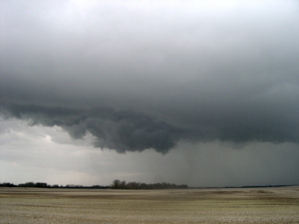
LONG day of chasing. I checked in to a hotel in Grenada, Ms about 1:30Am and crashed about 2. I knew storms were going to go early so I was out the door at 7am. I was hoping to get some discrete cells going in the Ms Delta early then move East through the day until I found myself in Al. We hung around the I-55 corridor waiting for something to happen but it seems like everything went at once and nothing really exploded. Most of the storms took at least some linear nature and I knew it was going to be a crapfest so I decided to dive down towards I-20 and come out around Meridian. The winds at the surface were SW or just west of South all through Western and central Ms but they began backing nicely right at the Ms/Al line. As I was making my way down through the middle of BFE when a cell in Rankin County (just E of Jan) was tor warned and that particular cell had been looking pretty good since it formed back in La. I made my way down to intercept it in Scott County and just as I got to the storm and punched the core it died out. However, the cell had split and still was better than anything else. Instead of trying to chase it through a poor network of roads in the woods I decided to stay south of it on I-20. It became severe again about 30 minutes later and went tornadic just before crossing into Al. I-20 goes due E from Jackson to Meridian then it goes NE to Tuscaloosa, Al. I shot up 20 and caught it in Jena, Al (about 20 miles SW of Tuscaloosa). At this point it was showing great rotation but another storm that had formed just south began to merge. There were two wall clouds. The first was on the southern part of the storm that was merging and the second was the main rotation. I drove directly under the first wall and the second looked terrific but I could not see over the hills/trees and there were absolutely no roads going farther north. I followed it NE on 156 and until the storm was not as impressive and another cell had developed just behind it and was becoming severe quickly. Within 20 minutes the wxworx was showing a TVS in nearly the same area the first rotation died out. I still could not get into position due to the lack of roads and just stayed a few miles south until 156 turned NE and I was in perfect position. The only problem was the cell was looking less than impressive by this time.

I continued up to HWY 82 and then went East near the airport. The cell was farther back to the West and did not look good. At this point Taco Bell was calling my name and I pulled in the drive-thru and placed an order. After I ordered the next scan came in and it looked great on radar, the TVS popped back up and I was stuck in a drive-thru with 3 cars in front and 2 behind. By the time I get to the window I could see the hail shaft (was quite impressive) and it was bearing down on me hard. I pulled out of Taco Bell and shot back West on 82 because I could barely see a dry slot back off to the W. As I was making my way up 82 I could make out the corner of the wall as it was wrapped in the core and I was in big trouble. I quickly turned around and it became quite a race. I was getting hit with some small hail but could see just a few hundred yards behind me and there was a wall of hail/rain. I managed to stay ahead of it until we hit a two lane bridge and the cars in front of me decided to go 10mph because of some penny hail. Little did they know reports were coming in over the radio of a large tornado on the ground just 2 miles back. I finally got out to I-20 and made it east a few miles to a shopping center on top of a hill just south of the interstate. I pulled to the top of the hill and got a very nice view of the hail shaft, dry slot and a new wall that had formed. The wall was well organized with scuds dancing as it came over the hill about a mile to my NE when it was just shredded apart. It came right over the truck and I think the rear flank choked off the inflow because the temp dropped off 12 degrees in about a minute.

After this I had enough and figured if I could not see a tornado in hills, trees, bad roads and racing storms then adding the element of darkness would not help. I would not call it a wasted day but when your target is 150 miles from the nearest tornado warned storm it sure makes things tough.
 
3/1/07 REPORTS: AL/MS/FL/GA

In comparison with the dramatic events around Enterprise, AL, this report will be weak.

I left Huntsville, AL around 11am--a few hours later than my original plan--to intercept the line of storms crossing the extreme NW corner of the state. Just east of Russellville, I encountered the most dramatic rotation around a horizontal axis I've ever witnessed; clouds were curling vertically upward and over the back end of the heel of the cb, almost like a propellor on a boat. The result was a hollow doughnut with clear air in the center. I was driving west at about 60 while the storm was moving NE at above 50mph and was unable to stop in time to catch the motion on video. This video capture below is looking back to the east--the rounded 'fuselage' pointing SW was the vertically rotating element, the axis being oriented NE/SW.

These storms calmed to steady anvil rain, so after a lunch I headed SE to the I-65/AL 157 intersection, driving through a small area of rich TD's near West Point. I returned to that area after a TOR was issued by NWS for the county and encountered the turbulence beneath the storm that had dropped two reported T's on Arley (with damage reported), about 25-30 miles south of my position.

After a turn southward on I-65 that included punching a vigorous precip shaft, I waited near Arkadelphia for the Tuscaloosa area storms to work their way into Walker County, but the significant ones seemed to make right turns toward Birmingham, so I gave up at about 5pm.

While I bagged no tornadoes, the rapid passage of the various systems was intriguing to watch, and the encounters with the boat-prop vortex and the remains of the Arley storm were memorable. Special thanks to Andy Kula of HSV NWS who was off today and helped with timely nowcasting.
 

Attachments

  • 3_1_2007 2_06 PM_0001.jpg
    3_1_2007 2_06 PM_0001.jpg
    11.5 KB · Views: 122
Last edited by a moderator:
Well....what a long day. Myself, Justin Chandler, and Matt Grantham headed out early in the day setting up in Tuscaloosa. We thought we might bust....but we were wrong. The first cell that went up was unwarned and actually was the only one in Tuscaloosa County to produce a tornado that I know of. I actually got this on film of where it was ripping the roof off of the only structure that it really hit in Samantha. I was in a hill just east of HWY-69 and the tornado was a few miles SW. The view was perfect as a base was present and this landspout tornado developed in seconds and discipated in seconds.

We intercepted several violently rotating wall clouds across Tuscaloosa and Jefferson County. Specifically....we followed all three tornado warned cells from TCL to Hueytown where we videoed a rapidly rotating LARGE wall cloud that may have produced further east near the Birmingham Airport where 4 homes sustained severe damage. Then, we witnessed a large funnel become rain wrapped as it went right over us just south of the 459/I-20 interchange near the Old Tuscaloosa HWY exit. Close to the West Bessemer area. This thing was at tree top level as we watched the consensed clouds boil upward and the entire meso wrap the rain on us!

All in all, what a day. I can only thank god that we are not dealing with the destruction that Enterprise, AL is dealing with. Maybe this event will convince EMA, school, and state officials to close schools for the entire day if you are going to close them.....or keep them in as long as you have to. If this had been the case....the kids would have likely been down in the hallways instead of in the gym because they couldn't load the buses due to the warning like they had planned.
 
3/1/07 REPORTS: IL

I decided to dust off the chase gear yesterday for no other reason
than working the bugs out and I didn't have to take a day off to do
it. Actually the chase day started at around 1 am in the morning
when flashes of lightning perked me from bed. I asked my wife if she
saw the flashes and she remarked that I was nuts as there is 2
inches of snow on the ground. Lo and behold the wx radio toned
and I decided to try and intercept the storm in my county being
warned for dime size hail. I managed to get to Dover,IL in time for about
4 minutes of pea size hail. I tryed to get a picture of lightning with the
snow on the ground but was unsuccessful. I did get a lightning
illuminated picture as the hail fell. In the years I've chased I've
never chased thunderstorms with snow on the ground.

hail_dover4.jpg


Later in daylight hours I initially intercepted a severe storm east
of Springfield earlier in the morning that was no more than little
wind and rain and then decided to head south via Rte 51 from
Decatur. I wanted to head farther south into the instability axis as
a line of storms formed NE of St. Louis. I did catch up to the
portion of the line that was warned for near Taylorville encountering
a little rain and wind.
aylorville2.jpg

This is the radar with my location marked by the black icon just
north of Taylorville.
taylorville_radar.jpg

From that image of note is the 30 knot sw wind behind the line and
the 20 knot SE wind just west of Decatur.I let the storm overtake
me while trying to find a road to follow.These pictures are looking
first to the northeast and then to the north when I got a little closer.
decatur2.jpg

decatur1.jpg

I did manage to find a road that paralleled the storm going northeast
in Blue Mound. I was delayed a little bit due to a freight train but
managed to catch up to the storm prior to entering Decatur on Rte
48. When I got to the intersection of Rte 48 and Rte 51 the tone
went out for a tornado warning in Decatur. I did not have a good
view, due to the city was between me and the storm by then. I
quickly took the interstate around Decatur and took this video
capture from the north side looking east from Rte 72.
decatur22.jpg


In retrospect I remember being frustrated that I could not get a
good view of the storm as I followed earlier due to the freight train
was paralleling me as I headed northeast on Rte 48. When the warning
went out I noticed there was a TVS marker and a bow on the cell on
radar but unfortunatley I thought I saved the image but did not.
After reading the LSR I found that I was a couple miles north of where
the tornado touched down when I received the warning, the cell was
farther east by then.
Just as well I had to get out and test the equipment for the new
season. I did have a half dozen computer freezes and the video
camera lens had a dirt spatter on it during most recording so I'm glad
to resolve some of these things and by looking at the calendar I think
I have a little
time.

Jerry Funfsinn
http://creativejetstream.com
 
Not a bust I guess, but not much in the way of tornadic pictures, etc. Target area was MS/AL/TN state lines, and down towards Tuscaloosa, AL. I left South Carolina early, but forgot one of my cell phones, (the one with the data connects to my laptop), so I had to return home to get it. Traffic was so bad in Atlanta, I went back north on I-85, and had to by-pass Atlanta way to the south. Finally, ended up between Tuscaloosa and Birmingham, and went on a wild goose chase south on I-65. Ken Hughey called and said I needed to be where he was...around tuscaloosa, so I shot up there in time to see a wall cloud disappear over a hill. Several warnings were issued for the Tuscaloosa area from around 4-6PM, and the skies were very ominous, but never saw anything that resembled an actual tornado. Most of the time, I was flying around from hwy 82, and I-65, but it seemed like every time when things started to fire up, they would just not completely reach maturation until they fizzled out. Also, I blew a fuse on my cigarette lighter, and lost my GPS, radar detector, and most importantly...my cell phone and laptop. (I always carry a second cell tho)All in all, it was exciting, and would do it again, but.....maybe next time! I AM glad there were no devastating tornadoes around tho...like what happened in Enterprise, AL, and some other places.
 
Last edited by a moderator:
Targeted Union Co storm and left here about 10:30. Storm was best on radar at 9:45. Waited it out about 11:15 south of the split due west of Vienna IL on I-24. Looking WSW was becoming obscured somewhat but no low level action present as storm passed by us about 1 mile to north. Kinda a low top cell appeared but its confirmed by KPAH an EF-0 touched down near Jonesboro IL. Weird but storm took right turn at time she produced, why we moved about 10 miles south. Decent early chase in March. Will try to post short video we took at Vienna
 
3/1/07 REPORTS: AL/MS/FL/GA

On Thursday I left Orlando at midnight trying to get in position for the day's activities with my target area being between Birmingham and Gadsden, AL. At around 7am, I stopped in Valdosta, Georgia to look at data including the new Day 1 Outlook. Seeing that the HIGH RISK had been moved farther to the south and seeing that the 4.0km WRF broke out discreet cells in northern FL, I decided to hold at Valdosta. Watching on the XM unit and monitoring sites via the Internet (thanks to all those hotels out there that provide unsecured Wi-Fi!) decided to reposition to Thomasville, GA which is only about four counties to the east of Enterprise, AL. I watched those storms moving to the NE but made the decision not to proceed further west because of the embedded nature of many of the cells. (If I had, I might have been in position to see the Enterprise tornado.)

I then backtracked to Valdosta (passing through some beautiful pecan groves) to be in position for what the models were advertising to be developing convection in north FL and southern GA. A mesoscale discussion was issued for the area I was in followed by a tornado watch. Since things looked capped down in FL and the models were not verifying for the development of storms, I decided to try and intercept the storm that caused the Enterprise tornado as it moved NW of Dawson and Americus.

As I got to Americus, preparing to circle to the N of the city, my nowcaster said that the circulation was decreasing but that a new storm to the SW was getting better organized. I went through Americus (passing, ironically, by the hospital, Burger King and Winn Dixie, which receive damage later in the evening) and headed north to Ellaville in Schley County. I stopped at the high school there and did some sky watching with low clouds streaming overhead at 800 to 1000 feet. A storm came out of Columbus and skirted the north end of the County. It had a lot of shear, as indicated by the XM, but I did not see anything and it was no longer tornado warned. Another storm was passing to my south but it too was below severe limits.

Being up since midnight, I thought about staying in Americus for the night but decided instead to head home. I drove south where I skirted the west side of the city on Rt. 19 to head down to Leesburg and then I 75 for the trip back home. As I was just south of Americus I drove through a cell with heavy rain and winds to 45 mph. Once through I was in the clear and headed home arriving back in Orlando at 12 midnight.

About 2 hours after I went thorugh Americus they were hit with another cell that did exensive damage in the city and, unfortunately, caused the loss of two lives. A tragic day with more loss of life from tornadoes but with the parameters so high, it could have been much worse.
 
Ha...you were right in my neck of the woods Kevin. I was sitting on the east side of Vienna in my house watching it rain. Was thinking about running over towards Anna earlier in the day myself so I could use SR 146 to run west to east in case they decided to pop, but they all looked like junk on GR. According to PAH however, she only caused damage for 2 minutes...but was moving 50 - 60mph. (Not fun in heavy rain.) Also a side note...the storm was never TOR warned, only SVR.
 
Last edited by a moderator:
Nice to see that fellow Illinois chasers are out and about...

This was a bust, and I wasn't going to a start a thread for this, but I'll chime in now that its up and keep it short.

Intercepted a severe warned cell near Gillespie, IL at 9:30am that was previously tornado warned in MO. Base was elevated and the storm was rapidly deteriorating so I abadoned it. Headed east on 70 to get out into the sunshine, ahead of developing cu field. I watched the cold front line develop from Vandalia with Scott Weberpal. We left keeping ahead of it on 70 hoping tail end charlie was get its act together or there would be a break in the line from which we could intercept a base. Caravanning with Mark Sefried and Andrew Pritchard, I finally got on the bottom end of the line near Clay City. Storms were deteriorating again at this point. Pictured here is a wall cloud wannabe on the gust front, just before we called this one a bust:

07030103.JPG
 
Yeah Was not intending on seeing anything big based on radar around 10am but ya never know, Any severe warning in a red box can spell trouble, that cell was ugliest on radar in KPAH area. Seen some low level pulse activity on SRM scan around 9:30 am so it beared watching. so we stayed close to my county (Williamson). It was open to SW side for a bit, but did become rain wrapped to our NW as it came by us. Again its early March & me thinks we are gonna get a rough season here in KPAH starting soon. Dont have a cell yet but partner does. Next adventure, maybe we can hook up around this neck-O-tha-woods. Lets just hope we dont see another Enterprise.....
Kevin
 
Missouri:

I left STL that morning heading SW on Hwy 44. I stopped at daybreak at Cuba, MO to wait for a tor warned cell that was a few minutes away. It was north of the hwy and headed NE so I was able to follow it up 44 all the way to STL. It had a WC and RFD most of the way there. As it entered STL County the WC was still rotating but as it crossed the city it became outflow dominant. From there I headed into central IL to play with the storms there for awhile. One storm had weak rotation but not strong enough to warrant a warning.
 
Drove all nite from Austin to Memphis (original target was Meridian, MS, but changed my mind in mid drive...). Slept a couple of hours in the car, and drove through heavy precip cores (and within a county of tornado warnings) to get to Birmingham around 2 p.m. Met up with my chase partner around 2:45 in West Birmingham- Storms crossing into AL from North of Meridian went tornado-warned around that time.​

We headed down I59/20 to Tuscaloosa. Observed the second northern-most cell (south of the Samantha cell, I think). It produced some flanking line funnels, and then a nice wall cloud came into view (roughly due W of Tuscaloosa). Cell was tor-warned at the time. Here is the large and low-based wall cloud at 3:30 p.m. In northern Tuscaloosa.​

TuscWall1_small.jpg


As we vainly chased this feature through residential, tree-lined areas, a second wall cloud formed to our south, associated with a second cell that was apparently merging with the first.​

We maneuvered out of the way of wall cloud #2 as it rapidly approached our location. Took some dime to nickel-sized hail during this time. Then, we followed the second wall cloud NE towards Birmingham as it nearly paralleled the interstate for the next 45 minutes. The three caps below show the varied forms this feature assumed as it raced NE. They were taken at 4:25, 4:31, and 4:36 respectively, all looking N or NW. At a little after 5, our chase essentially ended in downtown Birmingham.​

JeffWall1_small0.jpg


JeffWall2_small.jpg


JeffWall3_small.jpg


It would have been nice to see the base of these wall clouds, but it seems the entire I59/20 corridor between Tuscaloosa and Birmingham is lined with tall trees. Still, a fun chase, and some nice structures...

Miles: ~1800 (1690 in my car)
Quarts of Oil: 3

TonyC

 
I left Atlanta around 5am and targeted the Tuscaloosa area. The following vid caps are from 2 tornado warned cells approaching Tuscaloosa from the west. I was approx. 11 Miles SW of Tuscaloosa near Hwy 51. The times on the caps are set for Eastern, so subtract an hour for central time.

wall_cloud_1.jpg


wall_cloud_2.jpg


wall_cloud_%203.jpg


Other pics at :
http://stormready247.com/images/Storm_struct_1.jpg
http://stormready247.com/images/Storm_struct_ 2.jpg
http://stormready247.com/images/Storm_struct_%203.jpg
http://stormready247.com/images/Storm_struct_

My location is the little white cirlce, just to the south of the hook.

Base Reflectivity
radar_1.jpg


Storm Relative Vel
radar_2.jpg
 
Last edited by a moderator:
Back
Top