• While Stormtrack has discontinued its hosting of SpotterNetwork support on the forums, keep in mind that support for SpotterNetwork issues is available by emailing [email protected].

2026-02-19 REPORTS: IL/IN

Joined
Jan 14, 2011
Messages
3,636
Location
St. Louis
I went after the second round of storms on the dryline from Sandoval to Saint Peter, IL. The best I saw was this wall cloud/clear slot just north of Salem:

feb1926a.jpg

After this fell apart, I jumped over to the next cell to the northwest at Saint Peter. Strong RFD, but cold inflow:

feb1926c.jpg

feb1926d.jpg

RFD ripped my driver's side door out my hands and slammed it into the stops. No damage (I hope, we'll see if it leaks the next time it rains).

No tornado, but a nice, easy chase close to home.

More detailed log here:

 
Last edited:
Good chase day in Illinois for me. I jumped on the initial tornado warned storm near Wheeler to Newton IL watching some close tor attempts. Made the tough but correct call to drop south to the developing storm east of Olney and was able to catch a glimpse of a tornado WSW of Flat Rock (ground circulation confirmed by other chaser). Tried to keep up with it from the west but views and roads were blocked. Overall a good chase day especially for February and good to be on the board for 2026!IMG_5399.jpgIMG_5400.jpgIMG_5401.jpgScreen Shot 2026-02-19 at 6.22.34 PM.PNGScreen Shot 2026-02-19 at 6.24.14 PM.PNG
 
https://tonylaubach.net/chase-logs/chase-log-february-19-2026/

Not a chase I would've made from Denver, but was in Kansas City for a project, so it was an easy trip with a long haul home. Was a good dress rehearsal for the season testing new gear and setups. The chase itself was honestly pretty good for Mid-February. I didn't see any of the tornadoes, either was too brief or I was between cycles. Did get a helluva view of a cinnamon bun swirl south of Palestine, which of course happened between tornadoes on the supercell that ultimately ended up rolling through Bloomington. My chase was effectively ended by the accumulating hail that dumped out of the cell after it crossed the Wabash.

20260219f-1536x864.jpg


20260219h-1536x864.jpg


20260219m-1536x864.jpg


20260219n-1536x864.jpg


20260219p1-1536x864.jpg


Full Chase Write-Up: https://tonylaubach.net/chase-logs/chase-log-february-19-2026/
 
Targeted Effingham, IL for a two round play. Thermodynamics and shear looked decent from the start, so the noon round one looked like it might be in play. I tracked some rain showers south of Effingham, but that was a dud. The snow goose and greater white-fronted goose mass migration is underway here, something I haven't really witnessed at this scale, and I found the spectacle as impressive as anything from the chase:

260219lg0004.jpg

Doubled backed toward Vandalia for the next round, getting on a cell near Wheeler just as it became dominant, sporting a robust, broad base:

260219lg0005.jpg

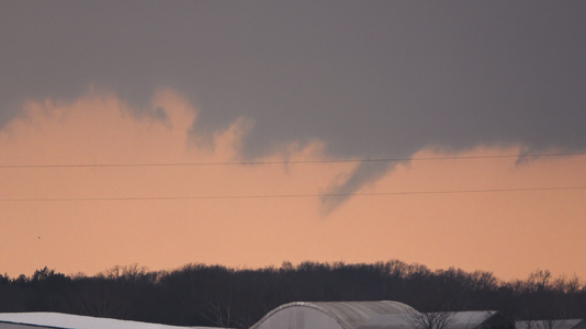
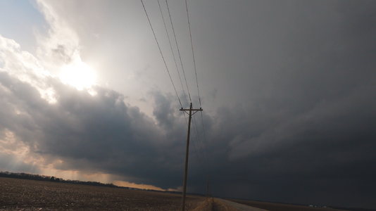
A scuddy lowering with twisting and rising motion had my attention, and very much reminded me of the start of the 3 January 2023 central IL tornado event:
260219lg0006.jpg
260219lg0007.jpg

For comparison, here's the start of the 3 January 2023 event, another low-topped cold air driven event where the occluded updraft was well south down the broad updraft base:
23010304.jpg

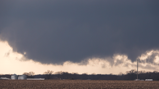
This time, however, the feature did not go on to spin-up a nice rope tornado but fizzled shortly later. The storm did go through several classic supercell cycles, however:

260219lg0009.jpg
260219lg0010.jpg

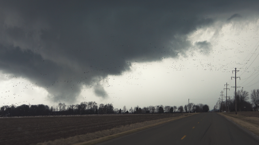
I drove underneath the RFD clear slot here, behind the bowing wall cloud, just as huge masses of geese started to rise from the field to the west. The "birdnado" was the highlight of the chase for me:
260219lg0013.jpg

260219lg0014.jpg

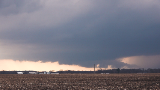
The cell went HP and I hung on it too long before bailing for the southern storm. Missed the EF1 tornado, and only got a glimpse of the remnant wall cloud from several miles behind the storm. Oh well, used to that by now. Going on a 20 month tornado drought.

260219lg0015.jpg

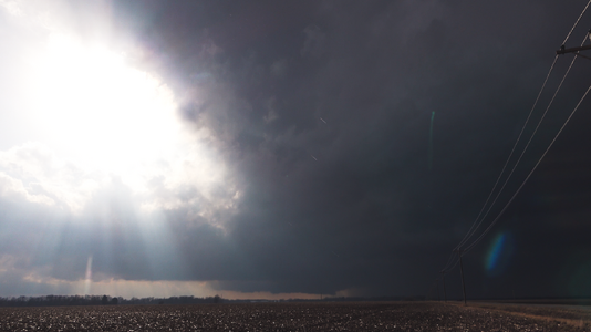
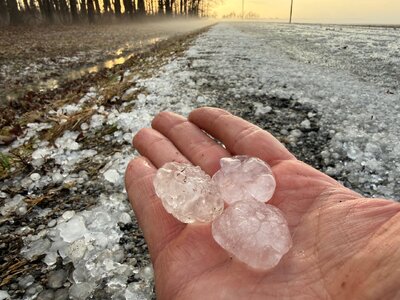
I tried to stick it out until nightfall and followed the storm into Indiana, knowing it was probably futile, but when I hit the hail drifts shown in Tony's shot above I was like screw this and turned around. I drove right past the tornado warned after dark stuff, but blew that off too, not wanting to deal with it. I'm trying to stave off burnout before the main part of the season even begins.

On a side note, the chaser traffic was almost as thick as the mass migrating geese. For a relatively modest setup, midweek, in February, in Illinois... that has me a little worried for the rest of the season.
 
Played the early tornado-warned supercell southwest of Effingham. Was pleasantly surprised by the fact I was able to set my cameras up on tripods and shoot time lapse of a classically structured supercell for half an hour without moving - that's always a joy and a successful chase day in my book, but especially so in February. Those 30 minutes of standing there with the inflow at my back and a rotating storm in front of me erased all of the chill of the recent cold winter. Documented several cycles, one of which apparently resulted in an EF-0 tornado near Edgewood, IL. On the board for 2026, though it won't end up framed on my wall.

I'd apparently been playing just ahead of the chaser hoards, because I was alone up until the supercell reached the Hwy 49 corridor north of Newton when I found myself in a sudden traffic jam. Reached a north-south T-intersection and everyone in the conga line went south - I assume a handful of them dropping south to the new, eventually tornadic storm near Olney. Simply wanting to get out of the crowd I went north and drove straight into the hail-filled RFD of the north storm as it tracked between Dieterich and Newton.

Coming in behind the storm the hail that was actually falling was relatively small, pea sized or so, but there was a solid coating of ping pong to golfball sized hail covering the road surface. This should have been my sign to photograph some hailstones and enjoy the vibes behind the storm but I continued on thinking I'd either catch back up to the north storm, or eventually drop south toward Olney.

Going east down a small rural road my right wheels clipped the hail-filled edge of the road and yanked my car toward the ditch. With an icy coating of hail and a steep slope I fought a losing battle against gravity for about 100 yards before my Forester slowly sank into the ditch. In my 25th year of storm chasing now, this is my first time being stuck to the point of needing an assist. Landowners saw my car from their house and came out to chat with me. Apparently he'd complained about the poor drainage in the ditch and it's scheduled to be dug up and fixed this summer, heh. At any rate, I love my Forester and its ability to handle thick mud and deep snow, but because of the deep standing water my left two wheels were basically halfway submerged and when I opened my drivers side door muddy water was up to the edge so I decided to accept the consequence and some professional help. The locals who were hanging with me had family who owned a tow business in Newton and their son eventually came and had me out in less than five minutes.

I was out and moving before dark, but decided to pass on and drive away from the second round of tornado warned supercells passing south of Effingham. This second round of storms ended up slamming the same spot where I was stuck earlier, glad I was moving because things could have become pretty sketchy with more hail and heavy rain, along with a possible after-dark tornado risk approaching. Part of me wanted to drop the 20 miles south for a look at these after-dark storms, but the better half of me was like, look, it's the first chase of the year and you're lucky as it is to be moving again.

Nice first chase, goofy ending, but makes for a memorable start to the season anyway.


Attachments

  • C0977.00_04_25_01.Still004.png
    C0977.00_04_25_01.Still004.png
    3.1 MB · Views: 2
  • C0977.00_06_05_23.Still008.png
    C0977.00_06_05_23.Still008.png
    2.8 MB · Views: 2
  • C0977.00_08_12_20.Still010.png
    C0977.00_08_12_20.Still010.png
    3.4 MB · Views: 2
  • C0977.00_09_57_13.Still009.png
    C0977.00_09_57_13.Still009.png
    3.5 MB · Views: 2
  • C0977.00_13_58_19.Still014.png
    C0977.00_13_58_19.Still014.png
    2.5 MB · Views: 2
  • C0977.00_16_09_03.Still020.png
    C0977.00_16_09_03.Still020.png
    3 MB · Views: 3
  • C0977.00_27_16_05.Still024.png
    C0977.00_27_16_05.Still024.png
    3.6 MB · Views: 3
  • IMG_9025(1).jpg
    IMG_9025(1).jpg
    323.8 KB · Views: 3
Back
Top