gdlewen
EF4
TL,DR: No tornado, but a cell merger which resulted in the formation of a persistent mesoanticyclone which coexisted and interacted with a mesocyclone.
INTRODUCTION
At around 00Z on September 21, 2025 (7PM CDT on 9/20), a thunderstorm cell merger took place W of Collinsville, OK. Originally, it just looked like a non-supercell thunderstorm close enough to offer the opportunity for some daylight lightning photography with my iPhone (to finish the “No iFrills iPhone Lightning Photography” post). Being in a neighborhood with houses that blocked the lower parts of the discharge wasn’t an issue for this test; what was required was an active thunderstorm just far enough away to provide a restricted FOV.
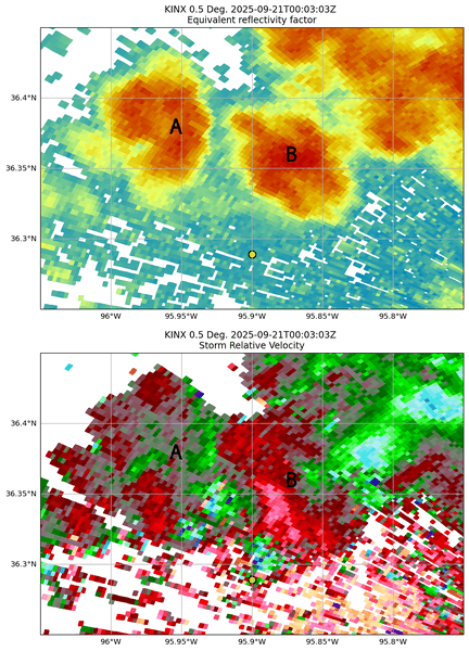
At 0003Z, KINX radar imagery didn’t suggest anything out of the ordinary:
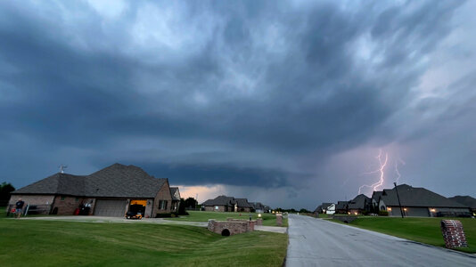
By 7:06 PM CDT, therefore, it came as quite a shock to set up my camera for lightning photography only to see a nice, laminar wall cloud (Figure 2) roughly NNW of my location.
From the ground, this appears to be a classic supercell, with FFD at right in the image. Any RFD precipitation would be hidden behind the house at right. But this is not a classic supercell. There are two distinct thunderstorms here, and this wall cloud is in the echo-free region between them:
It did not take long to perceive that the wall cloud is rotating clockwise, against a counterclockwise background.
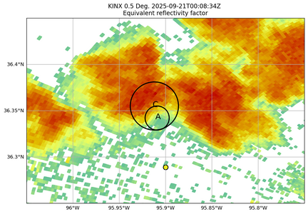
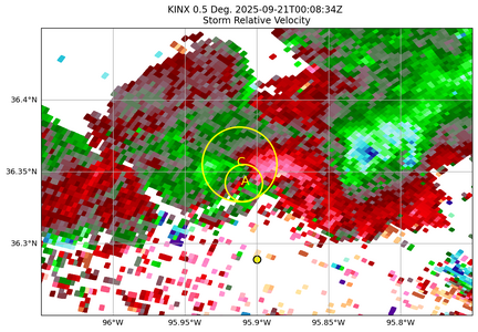
By 0008Z, the echoes were more or less continuous on radar, although from the ground, each presented a distinct precipitation core. Unlike the mesocyclone (which is quite prominent), the meso-anticyclone is really not evident in the Storm Relative Velocity scan (Figure 5b).
Local 0000Z METAR reports (Tulsa, Claremore, and Bartlesville) all reported scattered and broken cloud cover at heights of 300-600 feet AGL, which suggests low LCLs. Since the 0.5˚ elevation scan samples the atmosphere at an altitude of 1000-1300 feet AGL in the area of these circulation(s), it may be that the meso-anticyclone is below the radar at this point.
In Figure 5b, since you really can't see an anticyclonic velocity signature, if you weren't observing the storm from the ground there is no hint that anything interesting is going on. With its “kidney bean shape” and strong mesocyclone in the “kink of the bean”, you might be inclined to regard this as an HP supercell, but from the ground it appears that the mesocyclone is rain-free. In fact, clear sky is visible in the line of sight beneath the wall cloud (see, for example, Figure 6).
Given the history of this cell merger, and the fact the cells seem to have interacted ahead of the actual merger to create a mesocyclone/meso-anticyclone pair, I’m not sure what you would call this. (Perhaps, at this point it might be called a classic supercell if you ignore the "accessory anticyclonic wall cloud" feature.)
Aside: I did manage to get a CG flash to test the process of enfusing video frames. I guess it works okay, but the real test will come when I can image the flash near the ground, where the brightness will be much higher.
Eventually, the updraft begins to ingest rain-cooled air from what has become the forward flank precipitation core at right in these images. At this point, the anticyclonic wall cloud becomes more turbulent (Figure 7). It is significant to note that the developing inflow band wraps around in front of, and not behind, the wall cloud, again reinforcing the identification of the low-level circulation as anticyclonic. At no time did any rotating funnel-like feature develop.
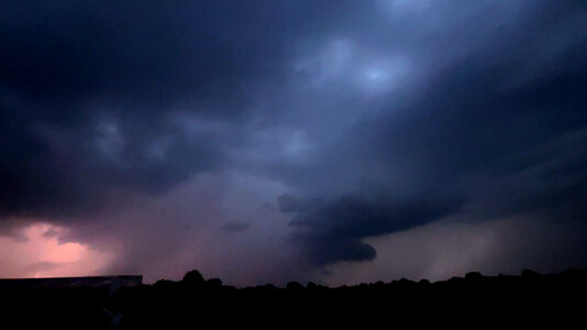
The thunderstorm complex barely moved during the period 0000Z-0040Z, by which time it was really too dark for photography. By 0034Z, the mesoanticylone had become rain-wrapped and all lighting was IC so there was no longer any potential for cloud-ground lightning photography and the "chase" (more like a walk) ended. One last video frame to document what what can now probably be called an "HP supercell".
SUMMARY: An unexpected event, and not like anything I have seen before. Although comments on REPORTS are not normally encouraged, I hope the moderators will tolerate some discussion about what has been documented here: a cell merger in which a circulation developed during the interaction between the cells as they merged and yielded a persistent meso-cyclone/anticyclone pair.
NOTES: Py-Art was used to process radar imagery storm-relative velocity was calculated using custom python code.
INTRODUCTION
At around 00Z on September 21, 2025 (7PM CDT on 9/20), a thunderstorm cell merger took place W of Collinsville, OK. Originally, it just looked like a non-supercell thunderstorm close enough to offer the opportunity for some daylight lightning photography with my iPhone (to finish the “No iFrills iPhone Lightning Photography” post). Being in a neighborhood with houses that blocked the lower parts of the discharge wasn’t an issue for this test; what was required was an active thunderstorm just far enough away to provide a restricted FOV.
At 0003Z, KINX radar imagery didn’t suggest anything out of the ordinary:
By 7:06 PM CDT, therefore, it came as quite a shock to set up my camera for lightning photography only to see a nice, laminar wall cloud (Figure 2) roughly NNW of my location.
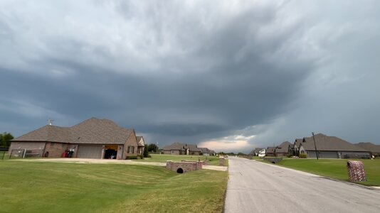 |
Figure 2. Video still from iPhone 15 video initiated at 7:06 PM CDT (0006Z). Looking N from Owasso, Oklahoma. |
From the ground, this appears to be a classic supercell, with FFD at right in the image. Any RFD precipitation would be hidden behind the house at right. But this is not a classic supercell. There are two distinct thunderstorms here, and this wall cloud is in the echo-free region between them:
It did not take long to perceive that the wall cloud is rotating clockwise, against a counterclockwise background.
| Figure 4. iPhone 15 video of anticyclonically rotating wall cloud starting sat 7:06 PM (CDT) on 9/20/2025. Due to the need to reduce the size of the video, the clockwise motion is not so evident until scud forms and moves from R->L late in the clip. If you expand the display to fill the screen the clockwise motion is much more evident. |
By 0008Z, the echoes were more or less continuous on radar, although from the ground, each presented a distinct precipitation core. Unlike the mesocyclone (which is quite prominent), the meso-anticyclone is really not evident in the Storm Relative Velocity scan (Figure 5b).
Local 0000Z METAR reports (Tulsa, Claremore, and Bartlesville) all reported scattered and broken cloud cover at heights of 300-600 feet AGL, which suggests low LCLs. Since the 0.5˚ elevation scan samples the atmosphere at an altitude of 1000-1300 feet AGL in the area of these circulation(s), it may be that the meso-anticyclone is below the radar at this point.
In Figure 5b, since you really can't see an anticyclonic velocity signature, if you weren't observing the storm from the ground there is no hint that anything interesting is going on. With its “kidney bean shape” and strong mesocyclone in the “kink of the bean”, you might be inclined to regard this as an HP supercell, but from the ground it appears that the mesocyclone is rain-free. In fact, clear sky is visible in the line of sight beneath the wall cloud (see, for example, Figure 6).
Given the history of this cell merger, and the fact the cells seem to have interacted ahead of the actual merger to create a mesocyclone/meso-anticyclone pair, I’m not sure what you would call this. (Perhaps, at this point it might be called a classic supercell if you ignore the "accessory anticyclonic wall cloud" feature.)
Aside: I did manage to get a CG flash to test the process of enfusing video frames. I guess it works okay, but the real test will come when I can image the flash near the ground, where the brightness will be much higher.
Eventually, the updraft begins to ingest rain-cooled air from what has become the forward flank precipitation core at right in these images. At this point, the anticyclonic wall cloud becomes more turbulent (Figure 7). It is significant to note that the developing inflow band wraps around in front of, and not behind, the wall cloud, again reinforcing the identification of the low-level circulation as anticyclonic. At no time did any rotating funnel-like feature develop.
| Figure 7. iPhone video initiated at 7:13 PM CDT (0013). As the mesoanticyclone begins to ingest rain-cooled air from what-has-become the FFD, the laminar nature of the wall cloud becomes increasingly more turbulent. Pay attention to the interface between the top of the wall cloud and the mesocyclonic circulation above it. Occasionally one can see a corkscrew feature as the anticyclonically rotating cloud folds into the mesocyclone. |
The thunderstorm complex barely moved during the period 0000Z-0040Z, by which time it was really too dark for photography. By 0034Z, the mesoanticylone had become rain-wrapped and all lighting was IC so there was no longer any potential for cloud-ground lightning photography and the "chase" (more like a walk) ended. One last video frame to document what what can now probably be called an "HP supercell".
SUMMARY: An unexpected event, and not like anything I have seen before. Although comments on REPORTS are not normally encouraged, I hope the moderators will tolerate some discussion about what has been documented here: a cell merger in which a circulation developed during the interaction between the cells as they merged and yielded a persistent meso-cyclone/anticyclone pair.
NOTES: Py-Art was used to process radar imagery storm-relative velocity was calculated using custom python code.
Last edited:


