Tony Laubach
EF5
I'm gonna be honest... this day was on the radar because I was to begin a cross-country haul from Colorado to Pennsylvania over the weekend and chasing on this day (a Friday) would saw off a few hours of that drive that I was planning to begin on Saturday. When I awakened the morning of, the setup looked bad, like had I not had an excuse to go out, I probably would've stayed home (more on that later on). But I had committed to TV work, and fortunately my live schedule only included two hits between 4p and 5p MT, meaning, in theory, that's all I needed to account for.
So, keeping true to my word, and despite my ho-hum attitude, I drove from my northern Colorado home to Cheyenne, stopping for Wendy's lunch and the Cheyenne Love's (there's a pattern emerging here) and waiting for storms off the foothills to get organized. And they weren't... 3pm rolled by and I was still sitting in the truck stop, but the dissipating showers to the west were offering up some mammatus overhead, so with something to shoot to play with for the upcoming hit, I decided to roll across I-25 and snag a few clips, figuring it would give me some window dressing for that first hit.

Upon shooting and phone-editing the clips, I thought 'to hell with this'... everything was struggling, including the storms to the north. A few showers were popping to my northeast, but I said to myself I wasn't going to venture far off I-80, and those were up in the Torrington region, and I had ZERO desire to ADD to my cross-country trip, so I thought to myself, 'ya know, I could venture to Pine Bluffs over there on the border and chop 45 minutes off the drive, haul form there to Sidney for the second/last hit and basically get a free 90 minute headstart'. So that's what I did, I drove over to Pine Bluffs and set up there at the rest area to do my first hit.
Well, plans change... a storm east/northeast of Cheyenne began to look interesting, and again, my playing the good TV boy, decided, 'ya know, it's only about 30 minutes back west, you can hit in front of that thing, give yourself a decent backdrop, and when the hit is over, you're still on I-80 and if it keeps looking bad, you're well on your way'.
Meanwhile, I was starting to hear of the landspouts near Brighton, Colorado. Brighton, as the crow flies, is about 20 miles southeast of my house. And I can armchair myself to death and say that had I been home, something would've triggered me out the door far enough to at least notch the belt with a view from the northwest, but who knows if I would've paid enough attention. Now normally, I could care less about missing landspouts, but I will get a bit miffed if they're spouts I could theoretically see from near my house. As I was westbound on I-80 approaching Burns, I was getting a good view of the developing storm in front of me. A few updrafts were popping on the leading edge of the storm as an outflow boundary from the northern cells was semi-slowing sinking south. What happens when you put an updraft over a boundary...

It was way to my west, put the Sony dash camera on full zoom to capture it. Was it a dust-devil? Was it a landspout? It was tall, and it was under an updraft, and while I was too far to see any cloud-based evidence, I logged it on the camera anyway. Several other chasers were closer to the storm, and I would put this between me and them (meaning if they were watching the storm, this was probably behind them). I haven't heard any other reports of this, so I'll just tuck into my pocket and move on.
I got off immediately at the Egbert exit, hoping that perhaps it would do it again and I could get a better, more stationary view. Of course, this would not occur again, so I grabbed some structure shots of the approaching storm, set up for my second live (and last) live hit of the evening, and gave a Emmy-worthy performance talking about the weakening storm to my west, but building towers back to my east.

The towers to my east had my attention; they were in front of the eastward pushing outflow and seemed unaffected by the south-pushing boundary, so it made sense to retrace my steps east on I-80. Meanwhile, another cell began to develop south of I-80, so I crossed the border into Nebraska and hopped off I-80 at Bushnell, dropping south on a dirt road as the storm was intensifying fairly rapidly, and certainly had more pizazz than anything else down here to this point.

The storm was super high-based, and I figured the tornado chances were low, but as I got south to within a couple miles of the stateline, I found a acceptable dirt road to lead me east toward NE-71. I was watching the storm intensify on radar, putting some hefty DBz into the core just off to my west, despite the visual core not looking that thick. None-the-less, I decided to give it to NE-71. My heart still wasn't completely in it, but certainly I was keeping enough interest to make the detour. So over to NE-71 I went, and I let the southern core approach as another core was developing just to my north. Figuring I-80 was my destination, and that core was quickly growing, I thought I'd take my chances with the northern core, hoping to get SOME hail. Well, I got SOME hail, but it was sub-severe, and mostly rain. A whimper under what radar presented was at least going to be a lot of small hail.
Meanwhile, north of that, another storm was getting itself together. I had eyes on it from far south, but radar was getting interesting. As I arrived to and turned east on I-80, I began to take notice of the velocity scans. While no tornado warnings were up for this yet, the severe-warning did have a 'Tornado Possible' tag to it. I didn't make it far down I-80 when the tornado warning went up, and I decided another detour was in order at Potter, so off the interstate I went and northbound on Road 77 I turned. There were three distinct areas of rotation to my north (about 10-15 miles), plus an area of enhanced velocity to my near immediate east. The severe warning would get the red box upgrade by this point.

I cut up through town and had eyes on a couple roads; Road 40 about 4 miles to my north and Road 44 a couple miles beyond that. Given the dirt, I opted for the closer Road 40 as it kept me a further form the precip core of the storms to my north, even as it still kept me 5-10 miles south of the rotation areas. But I was very much aware of the developing rotation to my immediate east, and with it being closer, I shot east to get to that while keeping my eyes on the north areas. While I did observe lowerings from the eastern most two, nothing tornadic showed up. I shot east, got around to the east side of the developing rotation, and it was visually looking better and better.

This was about the time the lightning machine began to shift into nutso mode... we weren't at the point of near constant CGs in every direction, but it was becoming VERY noticable.
Unfortunately, this storm was starting to become part of a growing line as the storms to the north (including the triplet rotation areas) began to congeal as more storms were developing south. This also meant precip was becoming more of a factor, and as much as I wanted to stay close to this, I was forced to retreat further east to ensure I wasn't getting stopped on slop roads.
I stair-stepped east and south, stopping somewhere north of Brownson to set up a view as an area of rotation was not only becoming more evident, it was really tightening up. I fixed my dash cam on the rotation area, and suddenly a funnel emerged (much more pronounced than the one I saw moments earlier). I was relaying this in realtime via NWS chat, and as I was in the middle of the funnel report, it touched down. TORNADO!

It would lift, touch back down, lift, and do it again. In view, but not great contrast. Enough to prove it was there. I stuck with it, the tornado circulation eventually ceasing as it was sliding south. I was sliding with it, eventually getting to 17A Road north of Brownson. I never saw another tornado out of this, reports say there was another which I either was blocked from view or had my back turned while in motion. Regardless, the structure was getting pretty good, and the lightning at this point was stealing the show (and preventing me from having anything to do with the outside of my car world.
I got to US-30 and found me a cozy spot, watching the relentless lightning barrage literally come down in every direction around me; some close, some far, some buried in the rain, but it a daytime strobe. Unreal.

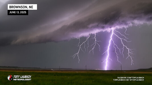
The storm was closing in again, so I dipped southeast on US-30 and dropped south on a dirt road between Brownson and Sidney to see if I couldn't snag some Nikon images. I pointed the car to the west, set my camera as wide as my lens could go (24mm), and adjusted the settings for 1.3" shots at f/7.1, braced the camera on the driver's side mirror, and started rapid firing.

The bolts were literally every second, I kid you not. Some in my field of view, others behind me, but it was constant. I wish I had a 360-degree camera. But in the area I was aiming, I picked off 19 total photos of the many I snapped in that 10 minute span. About half of those, with some cropping, were outstanding. A couple full-framers were like DAAYMMMNNN...


(Three-Image Composite I managed to Stack Despite the Handheld View)

It was freakin' Christmas! I wish I had more time, but the rain became an issue, so I had to back out of the area and get myself further east. I ducked back to I-80 as to avoid going through Sidney proper, and shot east toward Lodgepole where I got off the interstate one more time. I did a quick edit for my peeps, then decided, ya know, I think I can safely bail now. I was over-the-moon, a for sure tornado, a maybe landspout, disappointing hail, and a series of awesome lightning images/videos. Easily a grade-A chase on a day I was literally going to scrap in favor of more hours east to jumpstart my weekend drive. Was it worth the 1am arrival into Kearney...
ABSO-FREAKIN-LUTELY!!!
So yeah, amazing day, one where the tornado(s) took a backseat to everything else. I am absolutely thrilled with how the day turned out, and so glad I didn't write it off too soon and gave it some effort, cause it damn well paid off!
So, keeping true to my word, and despite my ho-hum attitude, I drove from my northern Colorado home to Cheyenne, stopping for Wendy's lunch and the Cheyenne Love's (there's a pattern emerging here) and waiting for storms off the foothills to get organized. And they weren't... 3pm rolled by and I was still sitting in the truck stop, but the dissipating showers to the west were offering up some mammatus overhead, so with something to shoot to play with for the upcoming hit, I decided to roll across I-25 and snag a few clips, figuring it would give me some window dressing for that first hit.
Upon shooting and phone-editing the clips, I thought 'to hell with this'... everything was struggling, including the storms to the north. A few showers were popping to my northeast, but I said to myself I wasn't going to venture far off I-80, and those were up in the Torrington region, and I had ZERO desire to ADD to my cross-country trip, so I thought to myself, 'ya know, I could venture to Pine Bluffs over there on the border and chop 45 minutes off the drive, haul form there to Sidney for the second/last hit and basically get a free 90 minute headstart'. So that's what I did, I drove over to Pine Bluffs and set up there at the rest area to do my first hit.
Well, plans change... a storm east/northeast of Cheyenne began to look interesting, and again, my playing the good TV boy, decided, 'ya know, it's only about 30 minutes back west, you can hit in front of that thing, give yourself a decent backdrop, and when the hit is over, you're still on I-80 and if it keeps looking bad, you're well on your way'.
Meanwhile, I was starting to hear of the landspouts near Brighton, Colorado. Brighton, as the crow flies, is about 20 miles southeast of my house. And I can armchair myself to death and say that had I been home, something would've triggered me out the door far enough to at least notch the belt with a view from the northwest, but who knows if I would've paid enough attention. Now normally, I could care less about missing landspouts, but I will get a bit miffed if they're spouts I could theoretically see from near my house. As I was westbound on I-80 approaching Burns, I was getting a good view of the developing storm in front of me. A few updrafts were popping on the leading edge of the storm as an outflow boundary from the northern cells was semi-slowing sinking south. What happens when you put an updraft over a boundary...
It was way to my west, put the Sony dash camera on full zoom to capture it. Was it a dust-devil? Was it a landspout? It was tall, and it was under an updraft, and while I was too far to see any cloud-based evidence, I logged it on the camera anyway. Several other chasers were closer to the storm, and I would put this between me and them (meaning if they were watching the storm, this was probably behind them). I haven't heard any other reports of this, so I'll just tuck into my pocket and move on.
I got off immediately at the Egbert exit, hoping that perhaps it would do it again and I could get a better, more stationary view. Of course, this would not occur again, so I grabbed some structure shots of the approaching storm, set up for my second live (and last) live hit of the evening, and gave a Emmy-worthy performance talking about the weakening storm to my west, but building towers back to my east.
The towers to my east had my attention; they were in front of the eastward pushing outflow and seemed unaffected by the south-pushing boundary, so it made sense to retrace my steps east on I-80. Meanwhile, another cell began to develop south of I-80, so I crossed the border into Nebraska and hopped off I-80 at Bushnell, dropping south on a dirt road as the storm was intensifying fairly rapidly, and certainly had more pizazz than anything else down here to this point.
The storm was super high-based, and I figured the tornado chances were low, but as I got south to within a couple miles of the stateline, I found a acceptable dirt road to lead me east toward NE-71. I was watching the storm intensify on radar, putting some hefty DBz into the core just off to my west, despite the visual core not looking that thick. None-the-less, I decided to give it to NE-71. My heart still wasn't completely in it, but certainly I was keeping enough interest to make the detour. So over to NE-71 I went, and I let the southern core approach as another core was developing just to my north. Figuring I-80 was my destination, and that core was quickly growing, I thought I'd take my chances with the northern core, hoping to get SOME hail. Well, I got SOME hail, but it was sub-severe, and mostly rain. A whimper under what radar presented was at least going to be a lot of small hail.
Meanwhile, north of that, another storm was getting itself together. I had eyes on it from far south, but radar was getting interesting. As I arrived to and turned east on I-80, I began to take notice of the velocity scans. While no tornado warnings were up for this yet, the severe-warning did have a 'Tornado Possible' tag to it. I didn't make it far down I-80 when the tornado warning went up, and I decided another detour was in order at Potter, so off the interstate I went and northbound on Road 77 I turned. There were three distinct areas of rotation to my north (about 10-15 miles), plus an area of enhanced velocity to my near immediate east. The severe warning would get the red box upgrade by this point.
I cut up through town and had eyes on a couple roads; Road 40 about 4 miles to my north and Road 44 a couple miles beyond that. Given the dirt, I opted for the closer Road 40 as it kept me a further form the precip core of the storms to my north, even as it still kept me 5-10 miles south of the rotation areas. But I was very much aware of the developing rotation to my immediate east, and with it being closer, I shot east to get to that while keeping my eyes on the north areas. While I did observe lowerings from the eastern most two, nothing tornadic showed up. I shot east, got around to the east side of the developing rotation, and it was visually looking better and better.
This was about the time the lightning machine began to shift into nutso mode... we weren't at the point of near constant CGs in every direction, but it was becoming VERY noticable.
Unfortunately, this storm was starting to become part of a growing line as the storms to the north (including the triplet rotation areas) began to congeal as more storms were developing south. This also meant precip was becoming more of a factor, and as much as I wanted to stay close to this, I was forced to retreat further east to ensure I wasn't getting stopped on slop roads.
I stair-stepped east and south, stopping somewhere north of Brownson to set up a view as an area of rotation was not only becoming more evident, it was really tightening up. I fixed my dash cam on the rotation area, and suddenly a funnel emerged (much more pronounced than the one I saw moments earlier). I was relaying this in realtime via NWS chat, and as I was in the middle of the funnel report, it touched down. TORNADO!
It would lift, touch back down, lift, and do it again. In view, but not great contrast. Enough to prove it was there. I stuck with it, the tornado circulation eventually ceasing as it was sliding south. I was sliding with it, eventually getting to 17A Road north of Brownson. I never saw another tornado out of this, reports say there was another which I either was blocked from view or had my back turned while in motion. Regardless, the structure was getting pretty good, and the lightning at this point was stealing the show (and preventing me from having anything to do with the outside of my car world.
I got to US-30 and found me a cozy spot, watching the relentless lightning barrage literally come down in every direction around me; some close, some far, some buried in the rain, but it a daytime strobe. Unreal.
The storm was closing in again, so I dipped southeast on US-30 and dropped south on a dirt road between Brownson and Sidney to see if I couldn't snag some Nikon images. I pointed the car to the west, set my camera as wide as my lens could go (24mm), and adjusted the settings for 1.3" shots at f/7.1, braced the camera on the driver's side mirror, and started rapid firing.
The bolts were literally every second, I kid you not. Some in my field of view, others behind me, but it was constant. I wish I had a 360-degree camera. But in the area I was aiming, I picked off 19 total photos of the many I snapped in that 10 minute span. About half of those, with some cropping, were outstanding. A couple full-framers were like DAAYMMMNNN...
(Three-Image Composite I managed to Stack Despite the Handheld View)
It was freakin' Christmas! I wish I had more time, but the rain became an issue, so I had to back out of the area and get myself further east. I ducked back to I-80 as to avoid going through Sidney proper, and shot east toward Lodgepole where I got off the interstate one more time. I did a quick edit for my peeps, then decided, ya know, I think I can safely bail now. I was over-the-moon, a for sure tornado, a maybe landspout, disappointing hail, and a series of awesome lightning images/videos. Easily a grade-A chase on a day I was literally going to scrap in favor of more hours east to jumpstart my weekend drive. Was it worth the 1am arrival into Kearney...
ABSO-FREAKIN-LUTELY!!!
So yeah, amazing day, one where the tornado(s) took a backseat to everything else. I am absolutely thrilled with how the day turned out, and so glad I didn't write it off too soon and gave it some effort, cause it damn well paid off!
Attachments
Last edited: