gdlewen
EF4
TL,DR: No tornado, but a supercell intercept in the OK panhandle that met, but did not exceed,
expectations.
SET-UP
The original target was NW OK, based on fairly consistent indications that severe thunderstorms would develop during mid-afternoon along a cold front forecast to be along the west OK-KS border. There were more uncertain indications of convection further south along the dryline in W-Central TX. Early morning HRRR runs were consistent (insistent) that OK panhandle convection would develop along the cold front, so that became the plan, for better or worse.
Convective initiation along the cold front began about 1245 PM CDT (1745Z) near Elkhart, KS., which was a bit earlier than expected. Nevertheless we arrived in Hardesty, OK around 2PM. From the ground, two distinct cells were visible, one NW of Guymon and a second, N of Hooker, which is 20 miles NE of Guymon. The cell NW of Guymon looks positively skeletal in this picture taken from the window of our car while en route at 1905Z:

The Hooker cell had a very high-based rotating wall cloud (not shown), but it’s the so-called "Guymon Supercell" that has my attention, despite its underwhelming appearance.
By the time we stopped just E of Guymon at 2:20 PM CDT, the target cell has visually a much more regular appearance, with prominent FFD and rain-free base. Still, there is as yet no evidence this will be worth the trip. A stronger cell has developed near Boise City, OK, but that is west of us and about 90 minutes away; without a good reason to abandon this cell and make the trek W, we decided to stick with this storm.

This storm is broadly rotating, and a developing wall cloud is building downward. Shortly thereafter, the updraft began to entrain rain-cooled air from the forward flank. By 2:45PM CDT a strong mesocyclone had developed just NE of Guymon. If the axis of the mesocyclone is assumed to be vertical, the center was about 6.9km NW of our position.

Assuming the center of the mesocyclone is ~7km away, that puts the lowest point of the rotating wall cloud at about 750m AGL. This is based on photogrammetric analysis of the outbuildings in the distance to calibrate a vertical scale. (It looks a lot closer and a lot lower than that.)

Not long after this (2:49PM CDT, or 1949Z), the RFD made an appearance on the horizon, which, due to the gently rolling terrain, is only about 1.5 km to the W, and marked by farm buildings and grain bins just visible in the distance. The mesocyclone is now 5km to our NNW.
A brief gustnado formed along the rear flank gust front to our W (low contrast so no image included), and literally only a minute later a very cold RFD arrived at our location. At this point the RFD is well ahead of the center of the low level circulation. It is difficult to see from images, or even from video, but the RFD appears to have undercut the mesocyclone, as any rotation in the wall cloud was masked by strong turbulence and the leading edge took on an arcus-like appearance.

At 1951Z a tornado warning (radar indicated) was issued for this storm, valid until 2015Z. We followed the wall cloud for another 20 minutes, since the storm trajectory kept it just 2-3 km off US-412 during our approach to Hardesty. A disorganized, barely-rotating wall cloud persisted but never got closer to the ground than about 500m AGL (no images included here.)
By 2010Z, it looks like a second low-level mesocyclone is present and separate from the stronger mid-level mesocyclone. Obviously you can’t say that for certain, based on only on radar analysis—the closest of which is 99 miles away—and single-point ground observations. However, it is fairly evident that the low-level circulation was coaxial with the midlevel circulation between 1920Z and about 2000Z, but by 2010Z this is no longer the case:

There is weak rotation evident in this “wall cloud” based on visual observation, and there is a weak signal in the velocity data (M1) but it is on a different azimuth relative to ground reference points than the strong midlevel circulation evident in the velocity data (M2). Whether or not you believe my correction for storm motion, it is clear from the ground-based imagery that the visual wall cloud, and its attendant weak rotation, is on n relative azimuth to the south of the stronger (M2) mesocyclone N of US-412.

Anyway, the FFD (with low visibility in heavy rain and hail) is crossing US-412 at an angle behind us, and basically chasing us E. We headed south to pick it up again north of Perryton. By this time multiple severe-warned cells had developed in the area and were congealing into a mess with nothing to offer but heavy wind, rain and hail. The event was over as far as we were concerned, so we called an end.
SUMMARY: This was far from a classic chaser experience--as others who chased on 6/8 noted, the "cold front play" was probably doomed from the start. But the goal was to set a target, intercept a supercell, and hope to "get lucky". From that point of view the day was a success: meeting, but not exceeding, expectations.
expectations.
SET-UP
The original target was NW OK, based on fairly consistent indications that severe thunderstorms would develop during mid-afternoon along a cold front forecast to be along the west OK-KS border. There were more uncertain indications of convection further south along the dryline in W-Central TX. Early morning HRRR runs were consistent (insistent) that OK panhandle convection would develop along the cold front, so that became the plan, for better or worse.
Convective initiation along the cold front began about 1245 PM CDT (1745Z) near Elkhart, KS., which was a bit earlier than expected. Nevertheless we arrived in Hardesty, OK around 2PM. From the ground, two distinct cells were visible, one NW of Guymon and a second, N of Hooker, which is 20 miles NE of Guymon. The cell NW of Guymon looks positively skeletal in this picture taken from the window of our car while en route at 1905Z:
The Hooker cell had a very high-based rotating wall cloud (not shown), but it’s the so-called "Guymon Supercell" that has my attention, despite its underwhelming appearance.
By the time we stopped just E of Guymon at 2:20 PM CDT, the target cell has visually a much more regular appearance, with prominent FFD and rain-free base. Still, there is as yet no evidence this will be worth the trip. A stronger cell has developed near Boise City, OK, but that is west of us and about 90 minutes away; without a good reason to abandon this cell and make the trek W, we decided to stick with this storm.
|
This storm is broadly rotating, and a developing wall cloud is building downward. Shortly thereafter, the updraft began to entrain rain-cooled air from the forward flank. By 2:45PM CDT a strong mesocyclone had developed just NE of Guymon. If the axis of the mesocyclone is assumed to be vertical, the center was about 6.9km NW of our position.
|
Assuming the center of the mesocyclone is ~7km away, that puts the lowest point of the rotating wall cloud at about 750m AGL. This is based on photogrammetric analysis of the outbuildings in the distance to calibrate a vertical scale. (It looks a lot closer and a lot lower than that.)
| Panorama of the "Guymon Supercell" taken at 1945Z. Looking NW. This storm structure was not so evident until the panoramic view was assembled from individual images taken with a Nikon-Z6 and stitched together using the application Hugin. US-412 is visible on the far left, and a utility access road is visible in the center-right, which is oriented N-S. |
Not long after this (2:49PM CDT, or 1949Z), the RFD made an appearance on the horizon, which, due to the gently rolling terrain, is only about 1.5 km to the W, and marked by farm buildings and grain bins just visible in the distance. The mesocyclone is now 5km to our NNW.
A brief gustnado formed along the rear flank gust front to our W (low contrast so no image included), and literally only a minute later a very cold RFD arrived at our location. At this point the RFD is well ahead of the center of the low level circulation. It is difficult to see from images, or even from video, but the RFD appears to have undercut the mesocyclone, as any rotation in the wall cloud was masked by strong turbulence and the leading edge took on an arcus-like appearance.
|
At 1951Z a tornado warning (radar indicated) was issued for this storm, valid until 2015Z. We followed the wall cloud for another 20 minutes, since the storm trajectory kept it just 2-3 km off US-412 during our approach to Hardesty. A disorganized, barely-rotating wall cloud persisted but never got closer to the ground than about 500m AGL (no images included here.)
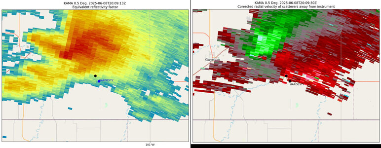
By 2010Z, it looks like a second low-level mesocyclone is present and separate from the stronger mid-level mesocyclone. Obviously you can’t say that for certain, based on only on radar analysis—the closest of which is 99 miles away—and single-point ground observations. However, it is fairly evident that the low-level circulation was coaxial with the midlevel circulation between 1920Z and about 2000Z, but by 2010Z this is no longer the case:
| KAMA Imagery of the "Guymon Supercell" for 2009Z on 6/8/2025. Velocity data is dealiased using Py-Art and storm-relative velocity is calculated using custom analysis. The "Stop Location" is indicated by a black dot and the location of Hardesty, OK is given for reference by a blue dot in blue text. Two mesocyclones are indicated: M2 an unambiguous mesocyclone and M1 the identification of which is less certain, based on the storm-relative velocity. |
There is weak rotation evident in this “wall cloud” based on visual observation, and there is a weak signal in the velocity data (M1) but it is on a different azimuth relative to ground reference points than the strong midlevel circulation evident in the velocity data (M2). Whether or not you believe my correction for storm motion, it is clear from the ground-based imagery that the visual wall cloud, and its attendant weak rotation, is on n relative azimuth to the south of the stronger (M2) mesocyclone N of US-412.
Image of wall cloud looking W of NW at about 2010Z on 6/8/2025, from a point on US-412 just NW of Hardesty, OK. US-412 at this point is oriented NW-SE, so the center of the visual low-level circulation is distinctly W of the strong mid-level mesocyclone M2, which is off to the right of US-412 in this picture. |
Anyway, the FFD (with low visibility in heavy rain and hail) is crossing US-412 at an angle behind us, and basically chasing us E. We headed south to pick it up again north of Perryton. By this time multiple severe-warned cells had developed in the area and were congealing into a mess with nothing to offer but heavy wind, rain and hail. The event was over as far as we were concerned, so we called an end.
SUMMARY: This was far from a classic chaser experience--as others who chased on 6/8 noted, the "cold front play" was probably doomed from the start. But the goal was to set a target, intercept a supercell, and hope to "get lucky". From that point of view the day was a success: meeting, but not exceeding, expectations.
Attachments
Last edited:

