Jeff House
Supporter
Saturday could offer some supercells in chasable terrain. Though the window is narrow both in space and in time.
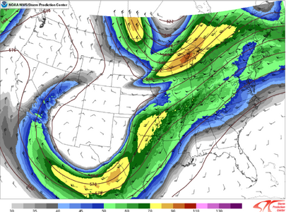
First upstairs the winds turn just enough with height. One challenge will be SW at 200/300 mb vs a nice WSW regime. Turning between 500-700 mb is meager plus a few other kinks in the hodograph are noted. That said the lower part of the sounding should be excellent. LLJ should respond to the approaching upper trough. Lowest levels should back especially if we can get a surface low in Arkansas.
Instability is robust in Arkansas and Louisiana. The Delta gets narrow into Louisiana but it is par width from southeast Arkansas into adjacent Mississippi. Speaking of Mississippi, low clouds need to burn off toward the earlier part of the model envelope. Otherwise decreasing instability will not help maintain any prefrontal cells.
Storm mode will be areal mess on the synoptic front. Chasers need the prefrontal trough to go ahead. That far south the turning with height upstairs is not great, but the instability is so. Could get discrete development right in that choice Delta terrain east side of the 10%. Even then they might not stay discrete for more than a couple hours, perhaps occasional discrete for max 3-4 hrs.
I infer the 06Z Day 2 tor probs are more for QLCS stuff by its location. Chasers really need something new going up on the LA/MS line also AR/MS if instability can get north a bit. I'm on the fence to go, but I figure it needs a thread.

