gdlewen
EF4
TL;DR: No tornado, not even a wall cloud, on a day with some promise and more hype, we got an LP supercell in N central OK that delivered hail and not much else.
Original target was Weatherford, but based on uncertainty in where storms would fire, we opted for a more central location. Started the day with lunch in Stillwater, and then proceeded to Guthrie to wait. It looked like convective initiation would be 21Z or later, so we split the afternoon between the Guthrie Public Library and Starbucks.
As of 18Z, there were still a lot of questions about where to be and when things would happen. Mid-50’s dewpoints had reached the OK-KS border. Nothing would happen for a couple more hours, however, until about 20Z (3PM CDT).
About 1951Z, movement of the dryline into western OK was marked by a radar fineline in the KFDR radar (not shown) and the development of cumulus along an axis from TX into west-central OK towards Weatherford (image courtesy of CoD). At 3:17PM CDT (2017Z), the SPC issued MD336 for the area.

The 21Z RAP convective temperatures (CT) showed a region of CT almost equal to the observed air temperatures in west-central Oklahoma…just ahead of the dryline. The lower convective temperatures were probably due to a softening of the cap between I-35 and the dryline, and signaled conditions for convective initiation were improving.

NOTE: At 22Z, the average of the low level cloud bases in the Enid area was reported to be 3500 ft AGL (about 1.1km). These cells formed on the western edge of the moisture streaming north, and in an area of relatively high LCL’s. Using the 22Z surface dewpoint-depression, we can see that LCL’s for this event were always going to be high:
Once the peak reflectivity of the "stronger" northernmost cell reached about 30 dBZ, I decided these were for real and headed north to intercept them near Waukonis. The target cell intensified rapidly, and it was clear we had gotten a late start on the chase.
As we approached from the south, the radial velocity scans looked very odd, even when using elevated sweeps to account for a potentially elevated base. It turns out there was a weak hail signature (WTBSS) present which was not too evident unless you checked the spectrum width, which I did not think to do until preparing this report.
We stopped at 6:00Pm CDT, just north of US-412 on the road to Garber. Probably could have shot E a bit to get closer, but we finally got a view through murk and decided to take stock of what was going on. This cell was rotating (video not shown), but visibility was extremely poor.
In the KVNX 3.95˚ reflectivity and velocity scans for 2305Z (shown below), the bold circle indicates the approximate position of the mesocyclone at 10,000 feet. A hail spike was removed before de-aliasing the radial velocity scan, but no attempt was made to compute storm-relative velocity primarily because the storm motion was more or less normal to the radial from KVNX.
The mesocyclone center is displaced S of the main precipitation core, and into an area of much lower reflectivity; given this and the high cloud base, identification as an LP supercell seems reasonable.
In progressively lower scans, the mesocyclone is displaced even further south and west: shifting laterally by about 5 miles between the 6.37˚ scan and the 2.37˚ scan: an angle of elevation of about 20˚ from the horizontal. (This seems like a lot of shearing to me, so I really doubt my numbers; regardless, I have not much experience in this area and really did not get a good look at the updraft tower from a distance.)
In the following panorama, the contrast was enhanced (within reasonable limits), but visually there was very little to see—just a low contrast band marking the cloud base to the north. Low clouds are already moving in to block our view of the updraft tower, so we headed north on OK-74.
END OF PART ONE
Original target was Weatherford, but based on uncertainty in where storms would fire, we opted for a more central location. Started the day with lunch in Stillwater, and then proceeded to Guthrie to wait. It looked like convective initiation would be 21Z or later, so we split the afternoon between the Guthrie Public Library and Starbucks.
As of 18Z, there were still a lot of questions about where to be and when things would happen. Mid-50’s dewpoints had reached the OK-KS border. Nothing would happen for a couple more hours, however, until about 20Z (3PM CDT).
 |
18Z METAR and Specific Humidity (g/kg) for April 1, 2025 |
About 1951Z, movement of the dryline into western OK was marked by a radar fineline in the KFDR radar (not shown) and the development of cumulus along an axis from TX into west-central OK towards Weatherford (image courtesy of CoD). At 3:17PM CDT (2017Z), the SPC issued MD336 for the area.
The 21Z RAP convective temperatures (CT) showed a region of CT almost equal to the observed air temperatures in west-central Oklahoma…just ahead of the dryline. The lower convective temperatures were probably due to a softening of the cap between I-35 and the dryline, and signaled conditions for convective initiation were improving.
 |
| 21Z RAP Convective Temperatures (CT) for April 1, 2025. The higher CTs in eastern OK mark the area of strongest capping under the EML. Note the region of lower CTs in near the dryline, which are nearly at reported air temperatures. |
Fast forward to 5PM CDT, and two blips of convection developed in the vicinity of Weatherford (image courtesy of CoD). The only reason to include this image is to point out how much middle-high cloud cover was riding over this area (and to remind myself how costly a simple decision to wait a few minutes can be.)NOTE: At 22Z, the average of the low level cloud bases in the Enid area was reported to be 3500 ft AGL (about 1.1km). These cells formed on the western edge of the moisture streaming north, and in an area of relatively high LCL’s. Using the 22Z surface dewpoint-depression, we can see that LCL’s for this event were always going to be high:
 |
22Z Estimated LCL heights in meters, based on METAR dew-point depressions.The red circle gives the approximate are of interest. (Credit to MetPy for analysis routines.) |
Once the peak reflectivity of the "stronger" northernmost cell reached about 30 dBZ, I decided these were for real and headed north to intercept them near Waukonis. The target cell intensified rapidly, and it was clear we had gotten a late start on the chase.
As we approached from the south, the radial velocity scans looked very odd, even when using elevated sweeps to account for a potentially elevated base. It turns out there was a weak hail signature (WTBSS) present which was not too evident unless you checked the spectrum width, which I did not think to do until preparing this report.
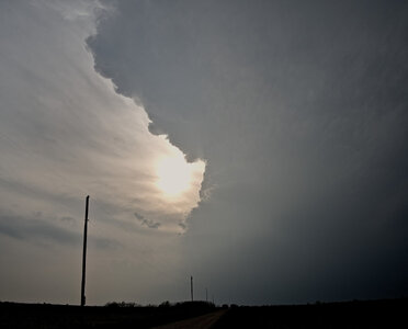
We stopped at 6:00Pm CDT, just north of US-412 on the road to Garber. Probably could have shot E a bit to get closer, but we finally got a view through murk and decided to take stock of what was going on. This cell was rotating (video not shown), but visibility was extremely poor.
Looking W on E. Chestnut Avenue, just west of OK-74, towards Enid. Nikon Z6 24mm f/6.3 lens; ISO 100; 1/250 sec. |
In the KVNX 3.95˚ reflectivity and velocity scans for 2305Z (shown below), the bold circle indicates the approximate position of the mesocyclone at 10,000 feet. A hail spike was removed before de-aliasing the radial velocity scan, but no attempt was made to compute storm-relative velocity primarily because the storm motion was more or less normal to the radial from KVNX.
The mesocyclone center is displaced S of the main precipitation core, and into an area of much lower reflectivity; given this and the high cloud base, identification as an LP supercell seems reasonable.
In progressively lower scans, the mesocyclone is displaced even further south and west: shifting laterally by about 5 miles between the 6.37˚ scan and the 2.37˚ scan: an angle of elevation of about 20˚ from the horizontal. (This seems like a lot of shearing to me, so I really doubt my numbers; regardless, I have not much experience in this area and really did not get a good look at the updraft tower from a distance.)
 |  |
| (a) 3.95˚ Reflectivity Scan for KVNX at 2310Z. Wind barb data from the OK MesoNet. The black circle is hand-drawn and marks the approximate position of the mesocyclone. (Analysis conducted using Py-Art.) | (b) Similar to (a), but for radial velocity. Clearly we are pretty far west. |
In the following panorama, the contrast was enhanced (within reasonable limits), but visually there was very little to see—just a low contrast band marking the cloud base to the north. Low clouds are already moving in to block our view of the updraft tower, so we headed north on OK-74.
 |
Panorama stitched using Hugin. Looking WSW to NNE. Images taken with a Nikon Z6 24mm f/6.3 lens; ISO 100; 1/250 sec. |
END OF PART ONE
Attachments
Last edited:


