Mikaela Norris
EF2
I left Altus, OK at around 430pm and decided to head west on US-62 towards Hollis, OK. At the time there were two established cells, one just south of Erick and the one I was heading towards near Hollis. There was also a 3rd, newer cell near Childress that was just getting going. The storm close to Hollis appeared to be the healthiest as I was heading west, so I decided to stay on it.
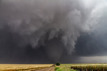
As the storm slowly pushed east, it made a few valiant attempts at tightening up, though nothing ever fully materialized. As this was happening, the cell from Childress had strengthened and begun moving northeast, pinching me between the storms in the process. I backed off east to the town of Duke and reevaluated. The cells were merging, with what appeared to be a new meso getting itself together to my southwest. I took OK-34 south to the junction with OK-6, and then down to Eldorado for a clearer view. Around this time I noticed the inflow into the storm was really starting to ramp up, which unfortunately began kicking up what seemed to me to be every piece of dust within several miles, thus obscuring any view I might have had under the approaching meso.

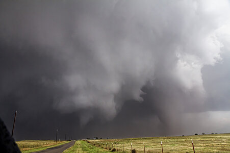
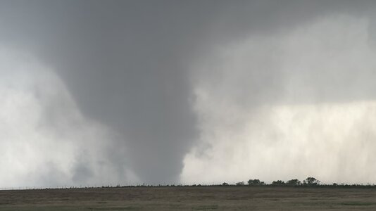
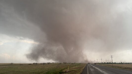
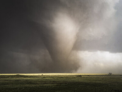
I decided to push back up OK-6 to OK-34 again. After going about a half mile north on OK-34, I was finally able to get a look. There was an obvious, though low contrast, lowering to my northwest. As it moved closer I realized it wasn’t just a lowering, but a tornado! As it moved closer still, I was somewhat surprised to see that it was not even just a tornado, but a large, multi-vortex tornado! I photographed it for several minutes, until it began getting a little too close for comfort.


Judging by the lack of significant left or right movement, I figured it was likely that the tornado was moving directly at me, so I moved south back to the intersection with OK-6, where I recorded the below video as the tornado approached and crossed OK-34. Unfortunately the wind was blowing directly into the microphone, so you can’t hear the roar of the tornado, but I definitely could in person.


This is what it looked like on radar around the time of the above three photos.

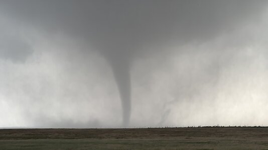
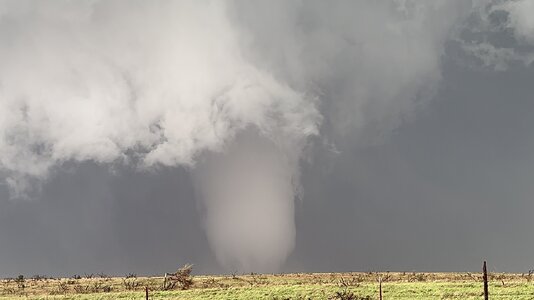
After giving it a few minutes to clear the road, I tentatively pushed back north and was treated to a high contrast view of the now stovepipe tornado as it moved off to my northeast.

I eventually lost it as it became rain wrapped. I moved a little further north and came across the damage path, which was marked mostly by snapped power poles. This ended up marking the end of the chase for me, primarily due to the road network in the area. OK-6 normally runs all the way north past OK-34 until it meets up with US-62 just outside of Altus, however the highway is closed between OK-34 and Olustee, OK. The detour route is to follow US-62 to OK-34 and then around to OK-6. With the storm becoming rain wrapped, and the only reasonable way home blocked by hailcores, I hung around waiting for things to clear up. In the meantime, the storm took a turn towards Altus, where luckily there doesn’t appear to be any significant damage. On my way I did come across more damage where it appears the tornado crossed US-62 between Duke and Altus. The west side of town didn’t have power when I got back, and there was some pretty significant street flooding along US-62 just outside of town. When I got back to my house, the surprises weren’t done yet. My rain gauge was showing 3.7” of rain had fallen at my house AND there was still a pile of hail in the corner of my patio, even though it had been close to an hour since the storm went through!
This chase season really has been my year, with today bringing my total for the year to 5 tornadoes. It has also been full of firsts. The firsts for this day include my first multi-vortex tornado, as well as the first time I had ever been close enough to hear the roar. I know many of you have heard that sound several times before, so I know I’m preaching to the choir when I say that other people’s videos don’t do it justice. You really do have to be there to fully experience what it is like. I know I keep going on and on, but it was just such a cool moment for me! I went into this chase not expecting much of anything except maybe some structure, but I ended up snagging the top tornado of my (admittedly) rather uneventful career! See y'all on the next one!
EDIT: I wrote all of the above between midnight and 2am, so I changed the final image to the photo I had originally intended to post, cleaned up some typos, etc.
I also wanted to take a minute to talk about the chaser convergence. It was pretty bad based on the sheer number of chasers alone. Limited space along the sides of the road, road closures in the area complicating things, plus the road grid in that area being mostly dirt rather than better maintained gravel I'm sure didn't help. Having said all of that, the only signficant issue I personally ran into was when I decided to move back south to give the tornado some more room. Several other folks made the decision to move at about the same time and I had to wait about 10-15 seconds for an opening to pull back on the road. Nobody was being erratic where I was, it was just congested. In this case it wasn't a big deal, and to my knowledge no chasers were impacted (at least none that weren't trying to be impacted). Had the storm been moving faster though, or perhaps shifted MAYBE a half mile south and pinched everyone against the road closure, it would have been a disaster for that many people to all try and escape simultaneously. In hindsight, it really wasn't a great place to be, even though it all worked out this time. I think my familiarity with the local roads may have made me overly confident. In the future, I should really keep in mind that road network familiarity doesn't mean a thing if traffic is at a stand still on the only paved escape route.
As the storm slowly pushed east, it made a few valiant attempts at tightening up, though nothing ever fully materialized. As this was happening, the cell from Childress had strengthened and begun moving northeast, pinching me between the storms in the process. I backed off east to the town of Duke and reevaluated. The cells were merging, with what appeared to be a new meso getting itself together to my southwest. I took OK-34 south to the junction with OK-6, and then down to Eldorado for a clearer view. Around this time I noticed the inflow into the storm was really starting to ramp up, which unfortunately began kicking up what seemed to me to be every piece of dust within several miles, thus obscuring any view I might have had under the approaching meso.
I decided to push back up OK-6 to OK-34 again. After going about a half mile north on OK-34, I was finally able to get a look. There was an obvious, though low contrast, lowering to my northwest. As it moved closer I realized it wasn’t just a lowering, but a tornado! As it moved closer still, I was somewhat surprised to see that it was not even just a tornado, but a large, multi-vortex tornado! I photographed it for several minutes, until it began getting a little too close for comfort.
Judging by the lack of significant left or right movement, I figured it was likely that the tornado was moving directly at me, so I moved south back to the intersection with OK-6, where I recorded the below video as the tornado approached and crossed OK-34. Unfortunately the wind was blowing directly into the microphone, so you can’t hear the roar of the tornado, but I definitely could in person.
This is what it looked like on radar around the time of the above three photos.
After giving it a few minutes to clear the road, I tentatively pushed back north and was treated to a high contrast view of the now stovepipe tornado as it moved off to my northeast.
I eventually lost it as it became rain wrapped. I moved a little further north and came across the damage path, which was marked mostly by snapped power poles. This ended up marking the end of the chase for me, primarily due to the road network in the area. OK-6 normally runs all the way north past OK-34 until it meets up with US-62 just outside of Altus, however the highway is closed between OK-34 and Olustee, OK. The detour route is to follow US-62 to OK-34 and then around to OK-6. With the storm becoming rain wrapped, and the only reasonable way home blocked by hailcores, I hung around waiting for things to clear up. In the meantime, the storm took a turn towards Altus, where luckily there doesn’t appear to be any significant damage. On my way I did come across more damage where it appears the tornado crossed US-62 between Duke and Altus. The west side of town didn’t have power when I got back, and there was some pretty significant street flooding along US-62 just outside of town. When I got back to my house, the surprises weren’t done yet. My rain gauge was showing 3.7” of rain had fallen at my house AND there was still a pile of hail in the corner of my patio, even though it had been close to an hour since the storm went through!
This chase season really has been my year, with today bringing my total for the year to 5 tornadoes. It has also been full of firsts. The firsts for this day include my first multi-vortex tornado, as well as the first time I had ever been close enough to hear the roar. I know many of you have heard that sound several times before, so I know I’m preaching to the choir when I say that other people’s videos don’t do it justice. You really do have to be there to fully experience what it is like. I know I keep going on and on, but it was just such a cool moment for me! I went into this chase not expecting much of anything except maybe some structure, but I ended up snagging the top tornado of my (admittedly) rather uneventful career! See y'all on the next one!
EDIT: I wrote all of the above between midnight and 2am, so I changed the final image to the photo I had originally intended to post, cleaned up some typos, etc.
I also wanted to take a minute to talk about the chaser convergence. It was pretty bad based on the sheer number of chasers alone. Limited space along the sides of the road, road closures in the area complicating things, plus the road grid in that area being mostly dirt rather than better maintained gravel I'm sure didn't help. Having said all of that, the only signficant issue I personally ran into was when I decided to move back south to give the tornado some more room. Several other folks made the decision to move at about the same time and I had to wait about 10-15 seconds for an opening to pull back on the road. Nobody was being erratic where I was, it was just congested. In this case it wasn't a big deal, and to my knowledge no chasers were impacted (at least none that weren't trying to be impacted). Had the storm been moving faster though, or perhaps shifted MAYBE a half mile south and pinched everyone against the road closure, it would have been a disaster for that many people to all try and escape simultaneously. In hindsight, it really wasn't a great place to be, even though it all worked out this time. I think my familiarity with the local roads may have made me overly confident. In the future, I should really keep in mind that road network familiarity doesn't mean a thing if traffic is at a stand still on the only paved escape route.
Last edited:


.jpg")


