2024-05-21 REPORTS: IA

Joined
Jan 16, 2009
Messages
754
Location
Kansas City
I chase Colorado yesterday drove all the way to Grand Island and stayed at a rest area. After 3 hours of sleep I headed towards Lincoln and got on the tornado warn cell that was South by Beatrice nebraska. I ended up like everybody probably following that one and watch the multiple drops here's a few of my pictures.

I will say a lot of people got ran over by that tornado we're lucky it wasn't very strong at the time.


Screenshot_20240521_160007_X.jpgScreenshot_20240521_152010_Gallery.jpgScreenshot_20240521_152947_Gallery.jpgScreenshot_20240521_160211_Gallery.jpgScreenshot_20240521_160153_Gallery.jpgScreenshot_20240521_160001_X.jpg
 
I started the day in Grand Island. I needed an oil change, so I got that done in Lincoln before heading east on I-80. Storms had already fired and were passing to the west, but these were elevated north of the warm front and were not a tornado threat. As I passed the exact spot where I'd shot the Waverly tornado less than a month earlier, I took a picture of "jellyfish clouds" (altocumulus with virga streaks) overhead.

I was initially pessimistic about this day's potential since the storms had been expected to form right on a surging cold front. Fast-moving cold fronts usually undercut supercell updrafts and disrupt their low-level organization, even if a potent tornado environment is present. So, my plan for the day was to see what the first cold frontal storms south of the warm front near Omaha looked like, and if they were undercut, head farther east for potential storms that models showed firing well ahead of the cold front. I stopped at Glenwood, Iowa to wait on new storms that just fired to the southwest. As the lead one approached, it appeared messy and potentially undercut already. Another supercell to its south was taking shape and had no other storms south of it, so I decided that this would be the last one before I would head east for the expected storms ahead of the front.

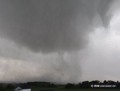
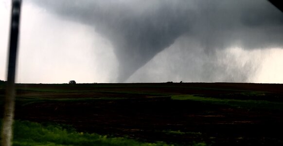
This second supercell displayed more classic radar presentation and looked like it might be just far enough ahead of the front to potentially do something. As I reached a viewing spot east of Red Oak, a strong circulation developed to the southwest of town. I went back west to get a better view, and saw a fast-moving tail cloud racing into a mesocyclone with rotating rain curtains. I started recording this, and it didn't take long for the tornado to develop.

I stopped recording long enough to report the tornado, then resumed filming as it grew into a nice fully-condensed stovepipe with a dense debris cloud:

may21c.jpg


may21d.jpg


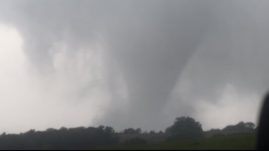
I headed back into town and south to see if I could manage a closer approach while the tornado thankfully roped out before entering town.

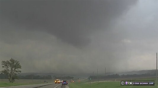
It was clear that the cold front was far enough west to not affect these storms! I continued east on Highway 34 to intercept the next storm, passing through its forward flank. When I emerged from the rain near Villisca, I could see another tornado developing to the south:

The tornado crossed the road ahead about a half of a mile away:

may21t.jpg


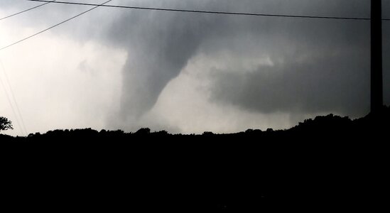
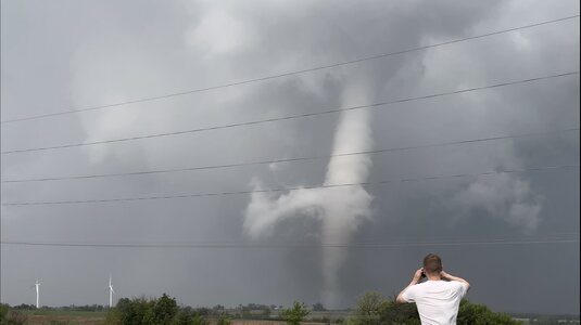
As the tornado moved north of the highway, another was rapidly forming just to its south and would cross the road ahead. I headed east to intercept the next tornado. This was the beginning of the EF4 that struck Greenfield:

may21u.jpg


I continued on to a better viewing spot to shoot the tornado moving off to the northeast, as it lofted trees into the air and displayed multiple vortices:

may21l.jpg


may21k.jpg


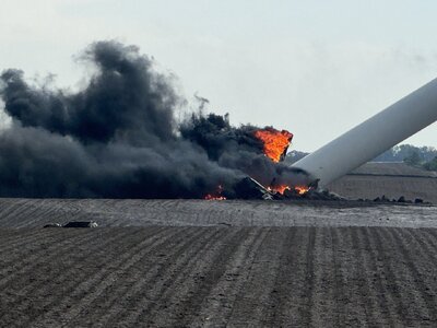
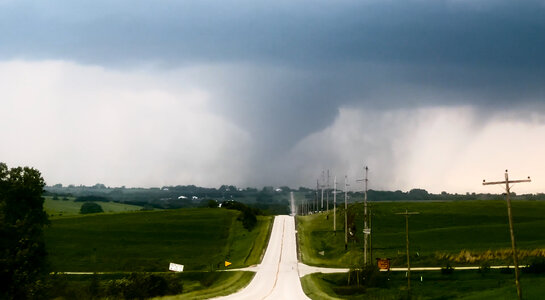
Still more supercells were organizing to the south, so there wasn't any time to spare. I headed east through Corning to intercept a new circulation getting started. I wanted to be east of this one for better lighting, so I drove east of where the circulation would cross. The RFD was full of heavy rain, however - and quickly obscured the circulation as it crossed the road to my west. About a minute later, I could see the tornado through the rain:

may21n.jpg


Again, there wasn't time to stop, as the road ahead turned northeast with the storm's hail core rapidly approaching the road. This caught up to me as I passed through Creston, but I was able to get back ahead when the road turned east. I intercepted a few additional supercells between Creston and Mount Pleasant, none of which looked close to producing a tornado. I encountered more weakening supercells between Keokuk and La Grange, Missouri which were all on a rapid downturn with shriveling bases. The cloud features, however, were very photogenic at the sunset hour. First, these mammatus clouds appeared to the north of Keokuk.

Then at La Grange, Missouri, this LP supercell was putting on quite a sunset display with anticrepuscular rays, lightning and storm structure. It was good enough that I stopped and set up several cameras.

may21p.jpg


More storms fired along Highway 61 as I entered the St. Louis metro area, but none were apparently producing anything photogenic to warrant stopping again. I made it home at 11:30pm, bringing the memorable and eventful Plains chase expedition #4 for the season to a close.

I edited a quick video of this day for Youtube:


Attachments

  • IMG_1890.jpeg
    IMG_1890.jpeg
    50.5 KB · Views: 101
  • may21h.jpg
    may21h.jpg
    28.3 KB · Views: 5
Last edited:
I drove from Colorado, but storms were already tornado warned before even reaching Topeka. Went through Kansas City and turned North. By that time there was a solid line from Iowa to Oklahoma. We ended up stopping on I-35 and letting the storms pass over and calling it quits. It was still over 70 miles to the storms that were producing tornadoes in Iowa. I was sick of driving and didn’t want to continue on,thinking the show would be over before I got there and the drive would have been more of a waste than it was. I was probably wrong, just as I was wrong when I picked the time to head out from Colorado in the morning. Kudos to people like Dan who sucked it up, put on their big boy pants and left early enough to get in on the show!
 
I figure since other people are sharing their successes, I'll share my miserable failure. I had already committed to play golf that evening since I run our league. I thought I'd chase for a couple hours since it's right in my backyard, then head to golf at a predetermined time so I wouldn't be late. It was a surging cold front anyway, and I've never seen one of those do anything cool in my entire career. Plus I've sworn off chasing fast moving cold fronts anyway, so the only reason I was out there was that it was literally a half hour drive from home.

I followed the initial tornado warned storm for nearly an hour and a half and watched as it didn't do much of anything. I was near Emerson, IA driving east on 34 and things were congealing into a line. I believe the only tornado warning at that point was for a storm far to my south. I was close to my stopping time so I turned around at Emerson to head home, only eight miles from Red Oak. Not two minutes after I turned around, that storm went warned. About five minutes later, I notice it start to get a fairly strong couplet. Five minutes after that the couplet was extremely strong and I said out loud to no one in particular that I bet it has a tornado. Then all the reports and images start coming in. Eight miles from where I turned around. On the same highway. Then another tornado about 10 miles further down the highway, then yet another a little bit further. I could have intercepted three tornadoes on my bike. Got home in time to see Reed's live stream of that tornado taking out the windmills before heading to golf. It was the biggest mistake of my career. Literally any other day of the week and I would have bagged at least three tornadoes, but nope, I wanted to play some golf.

I played an awful round too, as you might imagine lol.
 
My neighbor has been wanting to storm chase for quite a long time, so on Tuesday (May 21st) I took him out for his first experience. The Storm Prediction Center that morning had forecasted a Moderate Risk, 15% hatched significant tornado threat, along with issuing a PDS Tornado Watch just before Noon. I had a feeling we would at least be able to see something during our chase.

We left Kansas City mid-morning. Had I followed my first instinct and prepositioned in Atlantic, Iowa we likely would have intercepted the devastating tornado that directly impacted the small community of Greenfield. With very fast storm motions to the northeast and forecast models painting a line of supercells peaking across Central Iowa into North Central Missouri, I decided to change our staging location that morning to Princeton, MO.

Our first storm was a supercell that developed southwest of Mount Ayr, IA. It quickly developed rotation and became tornado-warned. We intercepted it near Grand River and stayed on it until Osceola. 2 brief funnels and a rotating wall cloud was the best we could get out of that cell.
IMG_2202-min.jpg
IMG_2196-min.jpg
IMG_2200-min.jpg

We then shot east to intercept another tornado-warned supercell southwest of Albia. This storm had at times a well defined rotating wall cloud and several reports of funnel clouds. We followed it to Oskaloosa where we had to abandon it due to it's forward speed and a less-than-desirable road network. Much like our first storm, it also was not able to tighten up enough to produce a tornado.
IMG_2210-min.jpg
IMG_2212-min.jpg
IMG_2214-min.jpg
IMG_2220-min.jpg
IMG_2226-Enhanced-NR-min.jpg

While our tornado count was zero for the day, it was a very successful chase being able to position ourselves in great locations should the storms actually develop tornadoes. And it was also a great experience for my neighbor as I was able to explain some of the processes and science behind severe weather and storm chasing.
IMG_2227-min.jpg
IMG_2229-min.jpg
 
I targeted too far east this day (initially went to Iowa Falls), thinking low-level winds were better backed east of I-35 and was a bit surprised all the significant tornadoes were produced where they were. SPC also seemed to think the potential was there, but storms appeared to struggle in the tornado department after passing the Des Moines area. Perhaps not enough time for recovery after earlier convection?

The first half of my chase was basically a race down I-35/US-65 south to avoid getting cored by the now nearly solid band of tornado and severe-warned cells flying up out of southwest Iowa. I cleared these and went east on US-34 looking to pick up a more discrete cell coming out of Missouri. I ended up on the second one that @Robert Reynolds posted above (in fact I'm probably just off camera to the left in some of his photos) from just south/southwest of Albia to Eddyville where I gave up due to storm speed. From there I took US-63 to Oskaloosa and IA-92 east (passing the location where I intercepted the Keota tornado last year) to start heading home. As I was almost home (and quite low on gas) I found my route blocked by downed power lines and had to detour, encountering multiple branches and trees down in the roads as the severe storms had produced one of the more widespread damaging wind events in recent memory for the Madison area.

 
Started the day near Red Oak Iowa, watched as the storms entered Iowa from Nebraska. Knowing the storm motions were moving quickly we hung out ahead of the south storms until it became clear the south storm near Viscilla Iowa was getting the look; we moved north and west out of Prescott Iowa and began heading west towards Carbon. The tornado came into view as we came upon the hill outside of town.

We followed the tornado on a north road for roughly 20 minutes as it fully condensed and became very photogenic, able to catch the best parts of the tornados life cycle.
 

Attachments

  • IMG_1234.jpeg
    IMG_1234.jpeg
    244 KB · Views: 9
  • IMG_1219.jpeg
    IMG_1219.jpeg
    104.2 KB · Views: 9
  • IMG_1216.jpeg
    IMG_1216.jpeg
    108.6 KB · Views: 12
  • IMG_1209.jpeg
    IMG_1209.jpeg
    81.4 KB · Views: 13
  • IMG_3220.jpeg
    IMG_3220.jpeg
    95.3 KB · Views: 13
  • IMG_1293.jpeg
    IMG_1293.jpeg
    693.2 KB · Views: 10
I finally made my chase video. Not sure why I waited so long considering it was a great chase day🤷‍♂️
I saw 4 tornadoes all along Hwy 34 starting with Red Oak.
Even when I was going to try and find a road to follow the tornado north, the next one was approaching the highway. It was crazy seeing 4 different tornadoes on 4 different cells in such quick succession!
I’m disappointed I didn’t get to see any of the tornadoes in their more mature/violent stage.

Here’s the video:
 
Back
Top