2024-05-20 REPORTS CO/NE/KS

JamesCaruso

Staff member
Joined
Jul 5, 2009
Messages
1,789
Location
Newtown, Pennsylvania
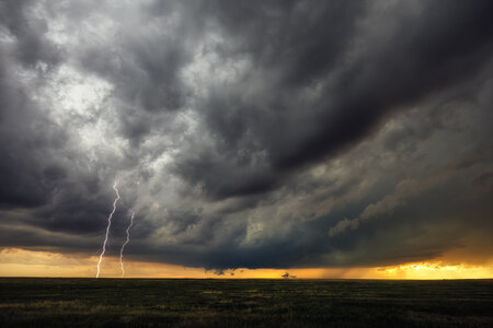
Sat in Akron for a couple of hours waiting for the convection S/SW of Fort Morgan to organize and move into the trajectory of low 50s dewpoints advecting into Yuma and Akron. One storm began to take on supercellular characteristics between 7/7:30 MDT.

IMG_2024.jpeg

By around 7:45 it had a severe warning and was TOR-warned just before 8pm MDT. We had been sitting on the north side of Akron so dropped back south through town as the sirens were sounding. It was a bit stressful getting through town and finding a clear view, I was worried I would miss something during that time, which would be ironic after sitting in one spot for almost two hours. We settled for this spot even though there were some buildings blocking the ground.

IMG_2025.jpeg

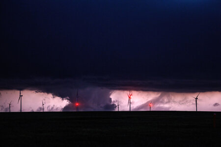
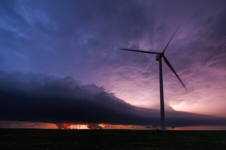
Not too long after, we had yet another HP mess on our hands.

IMG_2026.jpeg


The paved road network is terrible here, with the box bounded by Akron, Anton, Yuma and Cope/Joes featuring 30 miles between east/west options. We took a crack at an eastbound dirt road but as it was already low light, and not a perfect grid pattern (i.e.,, lots of dead-ends, T-intersections, etc.), we decided it just wasn't worth pursuing this HP mess. We went back to route 63 (the north/south road between Akron and Anton) and by then a new cell was TOR-warned southwest of Akron with a better radar presentation. A dirt road was pretty well lined up with the velocity couplet so we approached it and stopped to watch in near-darkness from about 5 miles out. The velocity couplet had disappeared, then it returned briefly, and disappeared again. Inflow remained strong but there was no real RFD. The inflow was likely contaminated by outflow from the Akron storm that was now near Otis. It was a cool eerie feeling standing there in the near darkness, with strong inflow, wind whistling through the power lines, and visible cloud motion overhead racing toward the updraft. When it was dark and no rotation was visible, we bailed to make sure we got off the dirt road before it got wet.

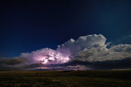
I considered going north into Nebraska to set up for the next day. This would have required a drive through the edge of the forward flank of the storm we were on, and behind the original storm now near Otis. I decided against driving in heavy rain at night and instead dropped south to Anton. There was another TOR-warned storm to the west of Anton so we figured we'd give this a shot. Once we got down there, we watched it for a bit in the lightning flashes. With just about every chaser in the country out there, hotels were filling up fast and the closest I could find was Colby. With a 2.5 hour drive ahead of us, meaning a post-midnight CDT check-in, we bailed.
 
I don't lean heavy on CAMs typically for targeting unless they are bullish on one solution for 10+ runs and don't conflict surface observation. HRRR was adamant about a likely scenario on NE CO yesterday, so the barbarian hordes were called. Dews were not impressive before heading out for the event, but I trusted NAM/GFS and surface obs. suggesting moisture was still surging in to the area around the low. For a one tank of gas kind of chase, I figured this would be worth the trip.

For Colorado, mid 50s dews is enough for tornadoes. Veering with height was actually nice from approximately highway 63 east to the CO/NE/KS border. Storms took forever to get going, coming as Palmer initiated garbage floundering for ~2 hours until they reached decent moisture and just enough upper support arrived. Around 6PM, two storms on the east edge of the garbage train finally started shunting the rest from the good moisture and low level wind and ramped up quickly with echo tops and lightning. I may have seen a brief weak tornado ~2 miles west of Akron, still reviewing video but there was rotating circulation under a wall cloud that was never condensed or particularly tight. The storm was HP and meso became rain wrapped fast. I could never visually confirm a tornado, but I don't count or particularly care as long as storms are photogenic and enjoyable.

I will add more photos of the Akron storm once I get a chance, but the highlight for me was dropping south once storm #1 became messier, to scrape by the southern storm passing over Last Chance. I made it past the hail core by about only a mile at Last Chance, playing an uncomfortably close game of chicken with the core (I don't like hail damage so I'm a bit conservative) to turn from 36 eastbound to 71 southbound. The risk was worth it as I got no hail and was able to get some decent structure shots. Checking video, but so far not able to confirm a tornado in this storm either.

442473950_10100694803810598_526008953531357382_n.jpg

For some reason my lightning luck was just awful on this chase, with amazing CGs that were very close but I was never pointed at the right spot or exposing while they hit. I'm sure my action cam video will be blown out or have rolling shutter. On my mirrorless, I forgot to bring a trigger for the earlier daylight shots, but did capture one CG I will post later, if it is decent.
 
I waited a long time South of Brush waiting for the storms to get going.The storms struggled like expected, but then came to life at a pretty rapid pace. We stayed with the tornado warned storm on the gravel side roads until getting to HWY 63 and the storm had become a HP mess by that point. There were a ton of people piled onto those side roads. We stopped briefly while heading South on 63 to watch the next storm in line for a bit, but ultimately gave up to go get a hotel at a reasonable time knowing there was a long drive in the morning to get to the hail covered race track to the East.
Most of the chasers out there did a great job leaving room for cars to pass on the side roads. One thing I saw a few times that made no sense were people parking on the storm side of the road and crossing the road in traffic to get to the opposite side of the road from where the storms were. It’s a bit nerve racking having people bouncing back and forth in front of you as you’re moving down the side roads. No tornadoes for me so I’m including a couple of structure shotsIMG_7756.jpegIMG_1032.jpeg
 
Last edited:
Same views as the previous posts so I won't post my structure shots of the first of the dozen or so pathetic showers that finally got going as it approached CO-71 SW of Brush.

My partner and I had initially targeted Akron, too (Jim, we were probably in proximity to each other at some point). But the first anvil to pass over us from the initial "puff"s back near Denver made it feel cool and unappealing, so we repositioned south on CO-63 to Anton and sat at the intersection (the Anton Supers) for a good hour or so. Honestly, by that point I figured we had busted - I've never had a good chase on a day in which there was basically no Cu in my area all afternoon. It was just too dry and the modified air mass wasn't recovering like we'd hoped. I saw more KH waves and mares tails than I did convection up to that point.

Finally, around 5:30 PM, we decided that if we wanted to see any convection at all (and to kind of start slowly mosey-ing our way home on an assumed bust) we decided to move west towards Last Chance to view a somewhat stronger shower that was further east and was showing more of a NE motion rather than NNE, as the rest of the showers were all doing. We ended up perched on a small hill about a half-mile east of CO-71 on County Road 26. Finally, one of the storms started to exhibit a fattening rain-free base and even a little bit of evident mid-level rotation, and some CGs began to occur. While it still didn't look particularly impressive on radar, it was strengthening, so we moved to stay with it as it began to cross 71. We were able to hop on high-quality dirt roads (County Road A/30) that took us all the way east back to CO-63 eventually. But it was along this stretch that the storm exhibited low-level/sub-cloud-base structure and even showed weak rotation in a wall cloud for a bit. That was also when the CGs went crazy off to the east of the storm...we were blown away by how many CGs were occurring 10-20 miles east of the eastern flank of the precip!

Unfortunately, after this the storm lost all sense of (exposed) low-level structure. There was a huge precip dump as the storm went HP. Velocity showed a gate-to-gate couplet buried pretty much dead center of the precip bomb, so if there was a tornado in there, it would have been completely invisible to anyone not in it.

After some dilly-dallying, we eventually continued east on the same road that went all the way through to CO-59 south of Yuma. We were pretty sure we were no longer going to see anything before this point, but decided to consider playing with the core up near Yuma. We ended up stopping along a few county road intersections along 59 a few miles south of Yuma to feel the roaring and moistened inflow. I was pretty impressed with how intense the inflow had become, and it definitely felt like there was some juice in it by nightfall (although it was kinda cold, too). It was weird watching the core grind to a halt west of Yuma - we sat waiting for a long time and it just never arrived!

Eventually we got sick of messing around and called the chase. The problem now was that we needed to get west to Denver and there was a tornado warned storm covering US 36, our most direct route back home. We figured, given as late as it was getting, and the fact that the entire convective system seemed to be evolving upscale, that by the time we got to it, it wouldn't be much of a threat. So we bypassed our last opportunity to divert to I-70 at Siebert/Arrickaree and just went for it.

At first it seemed like things were going to go well - the core remained just north of 36 as we approached and there was no longer any sustained organized rotation on it. As we approached Anton, however, a radar update showed a fresh core pop up directly on top of us, and within seconds hail began to fall. It was mostly sub-severe, but a few stones got to quarter sized. That was short-lived, but it was the first of 4 separate hail shafts we ended up punching through over the next 20 miles. The second one had larger and more sporadic hail, and it almost seemed like we were driving through a vault region on a disorganized supercell. Might have gotten up to 1.5" on that stuff. Then we sliced through whatever fat hook was actually south of 36 and at that point it felt like the whole storm decided to sink south onto the highway in an attempt to bury us. Between CO-63 and -71 we got clobbered. The third of the cores was probably the one that put a fresh spider-web crack on the edge of my windshield (that I didn't even notice until 30 miles later on). That core competes for the loudest hail I have ever driven through. I can only think of two other instances for me in which the hail was that loud - probably exceeding 100 decibels. My chase partner and I were basically yelling at the top of our lungs to communicate in it. And slowing down sucked because it was like we were driving on marbles. Finally, though, just before we got back to Last Chance, the precip cleared and we were able to make it back to Denver. We were still worried about the amount of rain that had fallen on this area and were watchful of covered highway. There was only one instance of water on 36 (just in front of a bridge, ironically), and it was only 1" or 2" deep and only 50 ft or so long.
 
I started the day in Russell and headed west into Colorado for the obvious target of the day. I waited for hours at Bennett watching weak storms struggle, until the storm of the day finally emerged. I got into position on this storm south of Fort Morgan, but decided I wanted to top off my gas tank in Brush before heading into a possible no-mans-land to stay with the storm. When I got back on the storm on dirt roads southeast of Brush, it was displaying great structure with a large RFD surge kicking up a lot of dirt. The north end of the RFD was wrapping up into a classic clear slot and meso that displayed intermittent funnels, and it appeared there were additional circulations to its southeast.

may2024a.jpg


Structure and strong RFD lofting dirt:

may2024b.jpg


may2024c.jpg


I had a great viewing position in the notch of the storm, but I'd been in mostly-continuous dime to nickel sized hail since arriving on it. Soon, golfball and larger hail started mixing in to the point that I had to move east. My hail shields protect the windows, but my headlights and taillights have no protection and I wasn't interested in hanging around in that situation. I never got completely out of hail for the next hour - my hood, roof and guards were taking sporadic golfballs and larger well into the forward flank of the storm east of Akron. Before I went through Akron eastbound, the couplet on the meso just to my west-southwest became very strong, but was completely rain-wrapped. This funnel-looking feature appeared in the rain to the southwest near Akron, but it was well to the south of where the couplet on radar was.

may2024e.jpg


I decided to drop south ahead of the storm at Otis. When I got downstream of the updraft, I could hardly see anything due to copious blowing dust and low stratus screaming into the storm from the east. I could only see the RFD gust front and some scuddy features under it in lightning flashes, but couldn't make out anything discernable.

I finally decided since it was 9pm, I needed to start heading north to I-76/I-80 then east so I'd have some time to sleep before Tuesday's chase. I drove back north on Highway RR toward Otis, but encountered 2.5" hail from the core peskily stalling over the road. I stopped to let this pass, then continued north. Almost immediately I encountered hail covering the road with a very thick hail fog. It was impossible to see the road. Even after slowing to a 5mph crawl, I was constantly driving off the road and down toward toward the ditches. With potentially 10 more miles of this ahead that likely would get worse the farther I went, I gave up and turned around after only 1000 feet of that..

may2024d.jpg


I had to go all the way south to Highway 36, then go east to Bird City, KS to get far enough ahead of the storms so I could go north. I made it to Grand Island for the night at 3am.
 
Last edited:
Left at about noon to head out to an initial waiting area in a Love's parking lot near Brush, CO. Got there by 2pm and watched some towers go up to the southeast near the Palmer Divide. Convection stayed pretty uninteresting until around 00z when a more easterly moving cell showed up ahead of a lot of the messy stuff. Decided to take a chance on that storm and went south from Brush around 00z. Got to Woodrow and sat for a while watching as the target storm underwent a merger. At about 00:15z it looked to be picking up steam so I went east along the dirt roads between Highway 71 and Highway 63. As I was moving east I noticed a considerable amount of scud getting sucked up into the base, accompanied shortly after by a substantial increase in CG lightning. During the latter portion of moving east, it appeared that the storm had a compact but persistent wall cloud. Once I got further east to Highway 62, I found a nice spot to pull off and point west. Not much to add photo-wise, but during this timeframe is when the storm went HP and let out the giant precip dump.

BaseMay20.JPG
PrecipDump.JPG

Recorded a fairly substantial inflow surge at about 01:14z but as mentioned by others, any tornado would have been virtually impossible to see without being practically in said tornado. Decided to move a few more miles south at about this point to get out of the way of approaching hail and to avoid the majority of the chaser convoy. Stopped again just west of the bend on highway 63 and let the storm move off to my north. At this point, it was fairly obvious that the storm was going to stay HP, and with night approaching, I had no interest in trying to get out front of it again.

MESOS-1_Sampling_Downsized.JPG

Continued mobile mesonet sampling in this location until about 01:30z when I then decided to drop southeast to a different tornado warned cell to sample ahead of it until nightfall. Once the light was gone, I called the chase with the intention of heading back via US 36, however a tornado warned storm over that route necessitated a change in plans. Decided to stop for a little while to enjoy the spectacular lightning show that it was producing before actually heading back. Didn't want to play the game of driving questionably maintained dirt roads at night, so opted to detour a ways east so I could have a paved route to get me to I70.

Not many pictures from this chase, but I was glad to finally get out there with some instrumentation now that the issues with it have been corrected. Still need to finish properly processing and QCing the data I was able to collect to see if there's anything worthwhile in there.
 
I don't have any photos much different from the ones already posted. Dan posted a good one where there was a large RFD cut. I thought this storm was about to produce at that point, but seemed the RFD was just too overpowering. Someone else mentioned a brief dust whirl at this time, I observed this as well. There was a tight area of rotation on the leading edge of the RFD at that point. Maybe technically a brief tornado.

Because I was still possibly considering driving out to Iowa today, I did go north through Otis on the back side of that lead cell. I might have passed you, Dan. The thick hail in the road wasn't there for too long, but I was only able to get through it thanks to someone else's tire tracks. It was also very difficult to see with blowing hail fog, heavy rain, and small hail still falling, but nonetheless I made it up to Sterling for the night. Decided not to drive to Iowa today. Went through Yuma where a hotel's siding had been completely obliterated by the hail!20240521_105302.jpg20240521_105324.jpg20240521_105335.jpg
 
I don't know why I cannot edit my original post. I hope I am not missing something obvious.

Anyway a few more images I gathered from this day. The first is the Akron storm and the only CG I caught out of dozens of spectacular ones. The middle images are the Last Chance cell near the Limon wind farm looking north. There was a lot of scud uptake, and in the lightning some of it was extremely persistent and looking like rotation in lightning flashes during the time of a couplet, but I could never confirm a tornado vs. just suspect ground scraping scud. Lastly, the end of the line storm was captured just as a freezing fog rolled in west to east, causing a lot of accidents and dangerous conditions. Seem many had a lot of trouble getting anywhere after about 9PM due to fog/hail/hail fog/flooding. As others have shown, this hail event is turning out to be a record breaker for rural Colorado into NE.
 

Attachments

  • 441454245_10100694977158208_635957476718264762_n.jpg
    441454245_10100694977158208_635957476718264762_n.jpg
    169.5 KB · Views: 7
  • 442409896_10100694977163198_8390569267316412175_n.jpg
    442409896_10100694977163198_8390569267316412175_n.jpg
    148.6 KB · Views: 7
  • 442511516_10100694977193138_1009994800846630776_n.jpg
    442511516_10100694977193138_1009994800846630776_n.jpg
    134.7 KB · Views: 7
  • 443716051_10100694977178168_7527744903055206526_n.jpg
    443716051_10100694977178168_7527744903055206526_n.jpg
    209.1 KB · Views: 7
Back
Top