• A friendly and periodic reminder of the rules we use for fostering high SNR and quality conversation and interaction at Stormtrack: Forum rules

    P.S. - Nothing specific happened to prompt this message! No one is in trouble, there are no flame wars in effect, nor any inappropriate conversation ongoing. This is being posted sitewide as a casual refresher.

2024-04-25 REPORTS: TX/KS/NE/CO

Joined
Jan 14, 2011
Messages
3,093
Location
St. Louis
I slept late, grabbed a coffee and departed Salina after noon. My target was northwestern Kansas where storms would interact with a stationary frontal boundary, but I was also watching for development down the dryline to the south. As I approached Colby, agitated cumulus developed into a thunderstorm south of Goodland, so I continued west to it. This storm reached the frontal boundary about 10 miles north of town, at which point it began exhibiting signs of a mesocyclone. An RFD clear slot cut in a couple of cycles, one producing this funnel:

april2524a.jpg


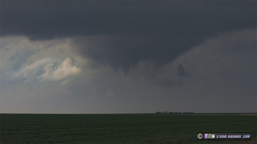
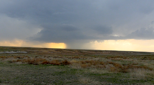
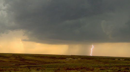
I did not see the rope tornado others documented around this time. After the storm was completely across the boundary, its structure diminished considerably. So, I turned my attention to new storms farther south. Some were already across the boundary south of Oakley, and more were traversing it - but none were developing good low-level mesos. One was producing some decent cloud-to-ground lightning here, so I decided to spend some time trying to catch a few. None cooperated for my camera.

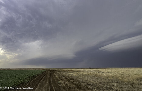
At this point, radar showed the boundary was being reinforced by storm outflow and actually sinking southward as a cold front. This pretty well spelled the end to any real tornado potential for the day. My oly play left was to get away from the boundary, down to the southernmost dryline storm near Syracuse. At Scott City, a new storm went up right over me that looked like it was in just as good of a position as the one near Syracuse. I decided to follow this one northeast, but it was high-based and never had a good look in its low levels.

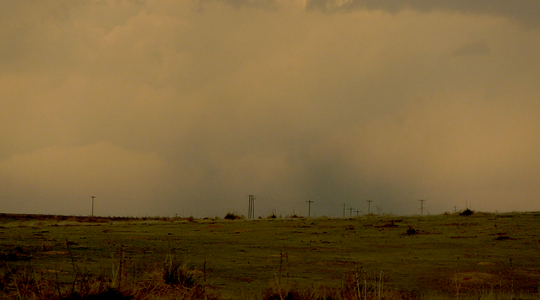
I had just reached I-70 at Grainfield when a new storm went up just south of the old one. This one intensified rapidly, with a couplet developing south of the interstate. The storm could not wrap up at ground level, as it was already north of the boundary with cold, stable air at the surface. It was also getting dark, and the grungy environment north of the boundary was making it difficult to see much of anything structure-wise. After this storm moved north of the highway, I called the chase and started heading east. I once again stopped in Salina for the night. I could have gone farther, but I wasn't sure which road I would need to take in the morning (either Highway 81 north or I-70 east).
 
I will write a full report later, but probably the most interesting thing I saw was this, as the new storm Dan mentions above had just formed. It was right on the frontal boundary, and it formed what looked like the world's longest beavertail/inflow tail. It extended for miles to the ESE of the storm. Actually, it was condensation along the frontal boundary being drawn into the storm's updraft. I was looking at from the southeast, at a location south of Gove:

Screenshot 2024-04-25 232534-2-e.jpg

Aside from that, I went in a lot of circles nearly every direction except south from Scott City. Saw a few OK supercells, but the storms interefered with each other too much for any one of them to really get going.
 
I could not leave KC until 11am due to an appointment. I drove down I-70 to Goodland KS and went north to the cell that was ramping up. Driving straight to the storm and arrived just in time to get in position. I was SW/S of Bird City when the funnel happened but I did not see it touch from my position to the east of it. I stayed with the storm until it crossed the front then moved south. I played around the junk storms for a while hoping one would get its act together but no luck. I called the chase at around 6:30 and stayed in Hays for the night. Looking at data and off to MO/IA today.
 
This seems to be the year of the mesocyclone [for me] thus far.

Began the morning in Kansas City, KS and headed west on I-70. My forecast focus zone [FFZ] remained relatively unchanged from 24 hours prior, along and south of a boundary/dryline intersection from I-70 extending along and west of HW-83 with an eastward extent bounded by HW-283. After clearing the severe warned mid/late morning convection along and north of I-70 around Topeka/Manhattan, I stopped for a late lunch in Hays before continuing west. Once the sun broke through, surface temperatures rose steadily to the 80-degree zone, with the boundary oriented just south of I-70 extending towards Goodland.

By mid-afternoon, a line of percolating cumulus developed, visible to the S/SW from I-70, along the tongue of moisture pointed towards NW KS/Goodland into NE CO. The first tornado watch was issued, and as expected, initial development began firing further west. Stopped for a time in Oakley and watched the northward encroachment of the boundary evolve. An eventual SVR warned supercell developed southwest of Goodland and began the trek northward. Shortly thereafter, a mass exodus of vehicles of assorted shapes, sizes and logos streamed steadily north, onward to the initial target jump play. I hesitated but did gravitate slightly west before stopping again to sample the atmosphere. Winds were out of the north/northeast as new convection moved over the boundary along/N of I-70. Temperature was 62-55 with Td around 48-50. Aware of the limited window for tornado production as the Goodland storm proceeded north of the boundary, regardless of good surface convergence, I turned back to HW-83 and headed south towards fledgling storms along the dryline in my original forecast zone.

A supercell eventually developed and split north/northeast of Leoti along the dryline and moved north/northeast gradually. Watched the morphology of the storm/bases as it meandered northward west of US-83. At this point the T/Td at my location was more tolerant at 75/58, with fairly high bases with strong east/southeasterly inflow. Additional storms began to the south, initiating what would become the dominant cluster mode to soon follow, yet the storm between Russell Springs and Elkader had enough space to evolve. Considered the southeastward moving boundary interaction with the northward moving storm may provide a window for a quick tornado. Mesocyclone evolution transpired, along with a brief downburst-spin up-cheesenado several miles away to my northwest of Elkader. Watched the storm until it crossed boundary into the cold air around Oakley, with cluster-mode now evident. Chase day was over. Fierce east winds, and later southerly, rocked the vehicle as I proceeded east to Topeka for the night.

Post facto: Too many storms populated along the US-83 zone dryline moving northward into southward the advancing cool, stable boundary of air. Dewpoints remained in the mid to upper 50’s the entire time. Large hail was the theme of the day, although I did not sample any of that. A few nice CG bolts, mesocyclone/s, and windy ambiance made for an enjoyable start to exploring the Plains floor for season 2024. Side note, I really must lay off the Steak burgers and beef jerky.
 

Attachments

  • 1.png
    1.png
    3.4 MB · Views: 6
  • 2.png
    2.png
    2.8 MB · Views: 4
  • 3.png
    3.png
    2.7 MB · Views: 5
Total Chase Duration = 9 hours
Total Distance = ~500 miles, Denver to Goodland to Denver
Chase Rating = Double Decker Dumpster Fire

Started the morning with surface obs. and a couple peaks at CAMs. Moved my previous night target from Scott City target to Colby enroute, and then again to Goodland. Plenty of time to make that drive from Denver with no struggle. By ~20z, sat at a travel stop south of Goodland to fuel, setup my GRlevel3 and action cam, etc. Realized I had forgotten my GPS antenna, so no superimposed location on my detailed radar and road layers on GR3. I really hate chasing from a phone screen personally, and no one makes a good GPS share app from phone to PC for modern android. Argghhh! Time to buy a new GPS antenna and leave it in the car!

Regardless, from just south of Goodland I was well positioned to watch the first and only tornado warned storm go up. It was struggling to break 30kft and echo tops showed two to three main updrafts fighting. Almost immediately had the look of a hailer, but got some brief rotation, so I pursued to just north of town. I tried a couple dirt roads to stair step closer, which started fine until I encountered some 'boat mud' so wasted precious time reverting to pavement on Hwy 27. I dallied a bit deciding if I was going to bail south before rejoining the storm. I just missed the brief tornado but saw an apparent receding funnel that was low contrast from my vantage. People still had cameras out pointed at the storm as I rolled by on 27 northbound.

I didn't even bother to get out my real cameras or to turn on my action cams this trip. I grabbed one cell shot as the storm was first going up, and one when the updraft began to have structure and base. Just about nothing was photogenic, and much of the navigation was in sludge fog. Saw the sun twice. :/

It was very obvious almost right away that remnant outflow was not oriented well and moving too fast for constructive interference. Storms were on the north side of the event were leaving for stable air gradually. So much initiated near the low and down the north part of the DL and got smashed by cap that there were outflow boundaries and cold pools everywhere by the time the cap was gone, so storms were sloshing around all over with no chance at organization or growth. Potential wasted. If things could have been a bit more discrete....

I had been excited about a 3 day chase, my first in 2 years, but last night I did not like the evolution of the Friday or Saturday setups in models, nor the locations, or precipitation and cloud cover interference. I decided the cost to stay out for conditional and potentially difficult to chase storms with questionable visible quality was more than I wished to spend. Headed back to CO to enjoy a quiet weekend and save resources and time off for May. Luck to all who are still out!

20240425_143905.jpg

20240425_151620.jpg
 
Pretty similar story and pics to Dan and Matt. Left Denver at noon and drove under the developing TCu that would become the storm in NE CO. It was high based, not very tall, and looked strung out and unimpressive to me, despite at an early point appearing to have a wall cloud (before it was even precipitating!). Had visual of a few of the updrafts that became "CI" in far NW KS as I was approaching Burlington and actually was within the first SVR polygon as I entered KS. Took a short look off the south side of 70 in Goodland, but decided to both anticipate an easterly component of motion as well as hedge on which of the numerous small storms from GLD to CBK would take over, so I moved east on 70 to the Brewster exit and headed north from there. Ended up finding out about the end of the paved road 15 miles north of the interstate and didn't want to push north to 36 on loose dirt road that would be wet to my north. I was a bit too far east to catch the tornado reports, but at some point I could discern a fuzzy/scuddy looking lowering beneath the base. Very little in the way of visible structure - the storm was already 20 miles north of the boundary so I knew the view wasn't going to last (given the widespread stratus that began about 20 mi north of the boundary at all points N and E from there).

Turned back south and began a course for the Oakley-Leota corridor to go after new storms going up along the DL. I was surprised at the number of chasers who were still busting north along the same road I was coming back down (probably due to the fact that the TOR polygon had been issued just a few minutes prior). Always a strange feeling when you're going the opposite direction as everyone else.

As I drove back to I70 and as I moved east on 70 the stratus built so fast overhead. I was in 500-ft LCLs at Colby and encountered about 60-s of sub-severe hail on the SE jaunt of 70 towards Oakley. I could see a base on that storm, but like Dan mentioned, it was already north of the boundary, and I didn't see any signs on radar that the boundary had stopped progressing. So I moved on.

Again, anticipating that one of the now several strong storms would become dominant and turn right, I opted to continue east on 70 until the Grainfield/Gove exit to cut south ahead of an anticipated path...only for that never to happen.

This was my first time off 70 in Gove County and man, does that area suck! I kinda needed to go to the bathroom, yet I couldn't find an open establishment from Grinnell until I had wrapped around to Scott City, long after I had basically called off the chase.

Had a couple bolts from the blue on my way to Scott City. Kinda neat, but they were too sporadic and close for me to pull off and attempt any lightning photography.

All-in-all, pretty lame. That boundary really f---ed things up...none of the models depicted it continuing to push so far south and west across NW KS. Even then it seemed like 00Z dewpoints ahead of the boundary were lackluster.
 
Another year, another few landspouts on April 25 for whatever reason.

The previous day I had identified an initial target area, and planned to start the chase somewhere between Brush, CO and Akron, CO. On the actual day of, my target area hadn't really changed and I still intended to target this area, but perhaps slightly more towards the east side as I still had lingering concerns about moisture maybe being a bit on the weaker side. Gathered my equipment and was out to Brush by 2pm local time. By that time, there was already some development on a storm southwest of Akron. While it wasn't particularly impressive, I figured that it could have reasonable potential later in the afternoon with some time to build and strengthen, so I decided to target it. I initially went south of Akron along highway 63 and watched strengthen for a while. Was pretty elevated at the time but I figured that if it could take root and really get surface based it might make a right turn.
Apr25Elevated (1).jpg
It didn't take a right turn and continued to be elevated so I decided to go north back to Akron where there would be a paved route east. Turns out I decided to do this just in time to be stopped by a train at a railroad crossing. After that, I got on the eastbound road to Otis. On the east side of Akron while driving I then noticed the ongoing landspout in the distance off to my southwest and managed to find a spot good enough to get a few pictures of it.
MainSpout (1).jpg
After that had dissipated, I moved further east to Otis where I waited and watched the storm slowly move northeast and develop further. Nothing particularly noteworthy occurred during this interval. After sitting and waiting a while I then moved north of Yuma and was overtaken by a shelf cloud which ended up being rather pretty with some very defined texture in the clouds.
WhalesMouthDownsized.JPG
Also in this area I noticed another dust whirl that appeared to be connected to the cloud base.
MiniSpout (1).jpg
After that I also noticed a suspect funnel-esque formation but I wasn't able to definitively discern whether it was indeed a funnel or just some deceptive scud.
ScudOrFunnel (1).jpg
Moved east a little more but it became apparent by that point the storm was getting messier and didn't seem to be particularly likely to produce much more of interest. However it had some pretty nice structure so I decided to go east a bit more to shoot some photo and video before calling the chase for the day.
Sculpt Downsized.JPG
Chase totaled about 440 total miles. Definitely glad I went out that day.
 
Last edited:
Back
Top