• A friendly and periodic reminder of the rules we use for fostering high SNR and quality conversation and interaction at Stormtrack: Forum rules

    P.S. - Nothing specific happened to prompt this message! No one is in trouble, there are no flame wars in effect, nor any inappropriate conversation ongoing. This is being posted sitewide as a casual refresher.

2023-06-15 REPORTS: OK/TX

I have flirted with never-ever posting this chase report, mostly because thinking of the day’s events makes me pretty cranky. But given some of the recent discussions involving “looking at data vs looking at the sky”, I decided to post this anyway. Maybe you all can add to what I learned from this chase.

The decision to chase on 6/15 was made largely based on a Consensus of CAMS, most of which showed discrete moderate-track supercells forming along the W-OK border with TX in the days leading up to 6/15. Assignment of a MDT risk to my target area in the 1630Z SPC Convective Outlook seemed to confirm this was a good decision. We drove over to Weatherford about 1300 CDT, to get lunch and watch and wait.

MCD #1076, issued at 1415 CDT, indicated that there was some residual convective inhibition over the area, and this seemed to be confirmed by the occasional elevated cumulus that formed and dissipated over Weatherford. Despite having a mushy, “heavy Cu” (HVY CU) appearance, they did not persist, so it looked like we would have a long wait. Therefore, when a cell first developed near Mangum, OK, we decided to head southwest to intercept it. (The argument was: if cells formed to the north (behind us) we would have time to double-back.)

The plan was adjusted on the fly to intercept the initial cell south of Hobart. By the time we reached Hobart, a second cell had formed, both featuring mesocyclones. This picture was taken at about 1530 CDT, just north of Hobart, looking south.

IMG_6847 - IMG_6849a.jpg

Cloud bases are clearly high, and in fact Hobart METAR reported a thunderstorm base of 5kft. (Obviously we are out of position, but it’s useful to correlate the view from the ground with the radar view.) The W-most cell appears to be LP. In the following radar view, my location is the blue dot near the "t" in Hobart.

KFDR_20230615_2030Z.png

We threaded through rain and hail as we headed south, still targeting the W-most cell. There were several attempts to initiate a rotating wall cloud, which dropped and retreated back into the updraft base—which was still very high. We stayed with it until it crossed Hwy 183 in front of us near the Tom Sneed Reservoir.

View attachment 20230615_Tom Sneed. WC.mov


The approximate position of the rotating wall cloud is indicated by the circle in the radar view below. The cell still has a decided LP-character. (Note: the relative velocity scan is at level "Tilt 3", which is approximately 5kt at the position of the visual wall cloud, so the radar is sampling the cloud base...as much as can be determined.)

KFDR_20230615_2110Z.png

At this point, I took a few minutes to check what was going on back north, and whether we should continue tracking this cell. Being unfamiliar with the unpaved roads in the area, it looked like I would not be able to pick it up again until somewhere W of Indiahoma.

I decided to carry on, but now it’s a genuine chase, and it quickly became apparent it was too late. The combination of not-really-being-in position and the time it took to review current conditions proved too much to overcome. The storm was traveling SE--the hypotenuse of a right triangle--and I was confined to the legs of that triangle. I could see the rear-flank gust front dust storm ahead of me, but could not even get close enough to see the (later-confirmed) Geronimo tornado through the murk. To make matters worse, the eastern cell went tornado-warned (over Lawton); it was already out of reach before we resumed the chase at Tom Sneed.

KFDR_20230615_2139Z.png

After about another half hour, we gave up. Eventually these cells did produce a couple rain-wrapped tornadoes well E of Lawton—one of which I think Reed Timmer saw “up close and personal”.

(I have been close to a couple of rain-wrapped tornadoes, and really don’t think of them as “worth the price of admission”: more like sitting in a car wash, but that’s my opinion.)

Summary—combining visual observation and radar data allowed us to identify and stay with a target cell. But it was not enough. I had no reason to target the E-most cell, and given the head start it had, might not have changed anything in the outcome. Question of the Day: Other than bailing and heading N at after the stop at the Tom Sneed Reservoir, is there anything that could have saved this day? Was the eastern cell the "correct choice" I did not make?
 
Last edited:
Good day all, this is my reports for June 15, 2023 in Oklahoma...

Summary: A rather complex setup presented itself for June 15, with two attractive target areas, one in the east-central to NE Texas Panhandle, and another in SW Oklahoma. I chose the latter one, as did many storm chasers that were leaning more towards the latter target. Both of these wound up producing tornadoes, with the more intense ones in SW to southern Oklahoma, and a devastating one in Perryton, Texas. I reached Elk City by early afternoon, and was pretty much on time for convective initiation. The SPC had a moderate risk in place, with a 10% tornado probability, and both significant hail and wind probabilities at 45% (hatched). Mesoscale discussion 1076 was issued, then tornado watch box 307, valid until 10 PM CDT as well. The chase track initially was near Hobart, and southeast of there, via SR 6 and 152, then Highway 62 to near Cache. The storm became a powerful HP storm, with rain-wrapped tornadoes. Flying debris and a roof torn off and landing in an intersection in Comanche was also noted, near SR 53 and Highway 81. A wedge tornado was also observed shortly after looking west towards Comanche and near Loco on SR 53. I approached the Red River east of Ryan, and south to cross into Texas to near Saint Jo on SR 89. I then headed east towards Gainesville, Texas on Highway 82 to near I-40, before letting the storm go. Damage was also observed in Gainesville. I backed west on Highway 82 after a fuel stop, targeting another tornadic storm southwest of Saint Jo and near Montague. Night came fast at this point, so I wrapped up the chase, heading back east on SR 59 to SR 89, back north across the Red River into Oklahoma, and east on SR 32 to SR 76 north to Highway 70 east to I-40. I took I-40 north to Moore, Oklahoma, and spent the night there.

Full online chase log for 2023 (including this one) can be found here: www.sky-chaser.com/mwcl2023.htm

Details (on June 15)...

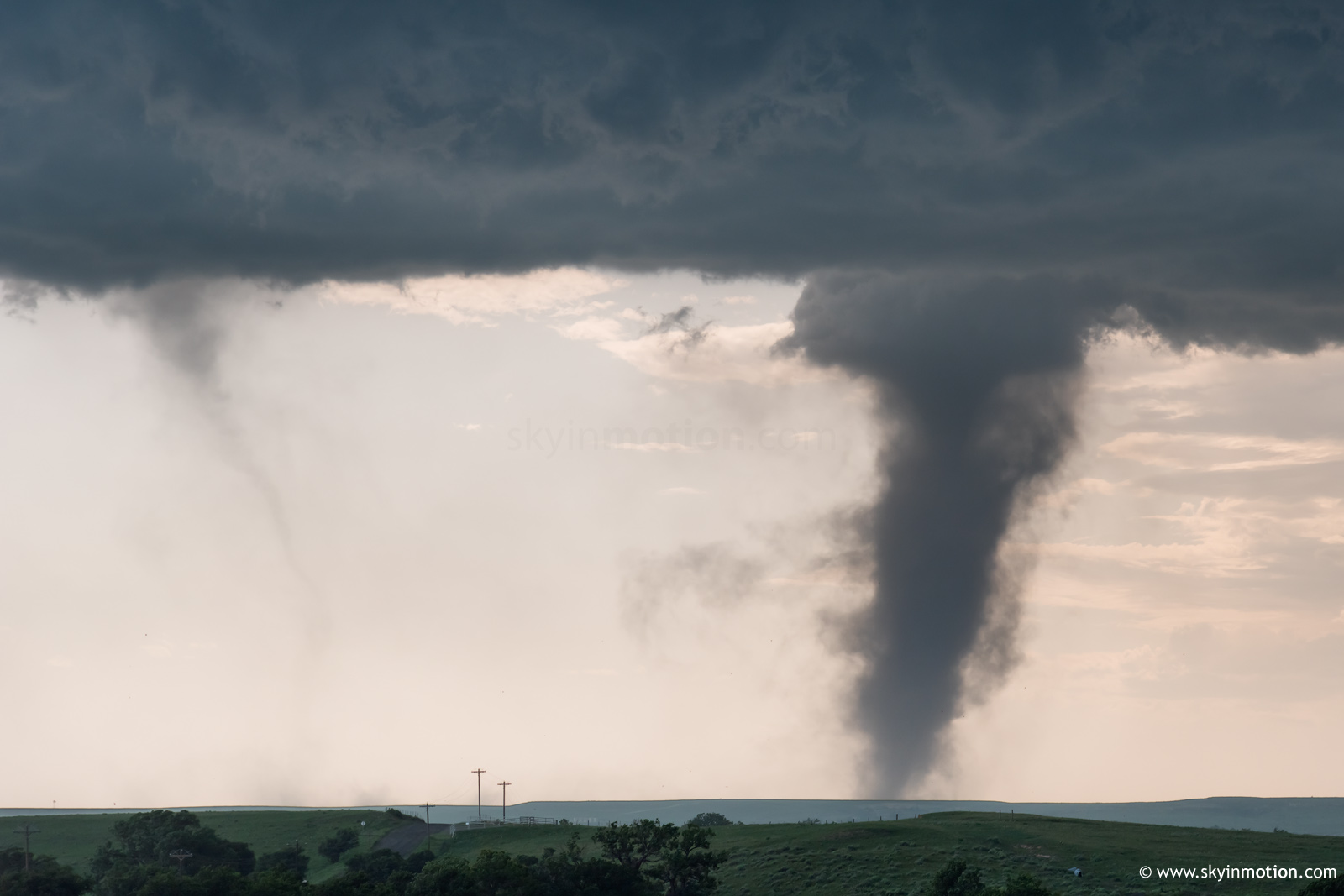
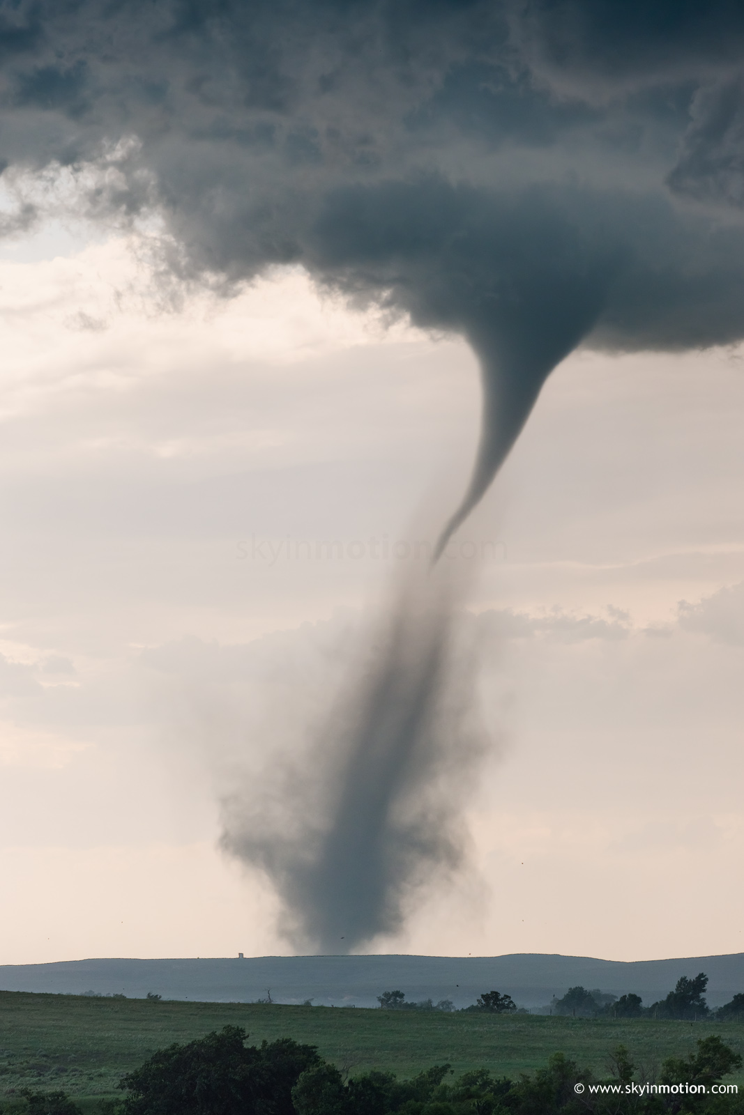
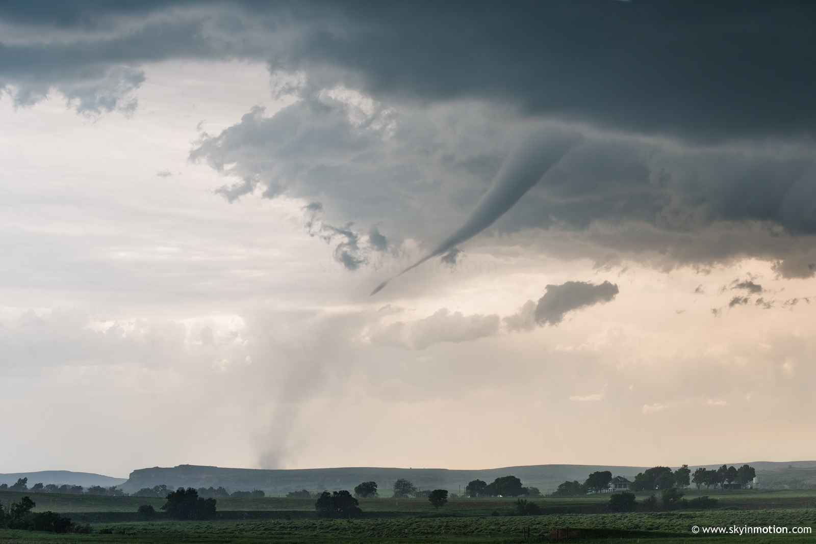
1). June 15, 6:00 PM
- Observation and indirect penetration of an extremely severe and tornadic thunderstorm on a long path from near Hobart, Oklahoma in Kiowa County, and points southeast passing Cache, Comanche, and Loco in Stephens County, mainly near Highway 81 and SR 52, and eventually across the Red River and as far as Cook County and Gainesville, Texas near I-40 and Highway 82. This storm was a powerful cyclic HP supercell. During its life-cycle, it produced several tornadoes, mainly rain-wrapped. A large wedge tornado was observed, albeit low-contrast, looking west from near Loco and towards Comanche. While passing through Comanche, flying debris was noted, power out, and a large metal roof flew through the air and landed at the intersection of SR 52 and Highway 81. Two other weaker tornadoes were also observed. This storm also had two areas of rotation at one point, before a cell merger took place later in its life-cycle. Earlier the storm produced RFD winds exceeding 60 MPH, especially in Kiowa County and west of Cache. The core was not directly penetrated, but hail just under 2" was noted (the main core had wind-driven hail exceeding 3"). This cracked the windshield west of Hobart. The storm caused damage from near Duncan to Loco, and later more damage was noted in Gainesville, Texas near dusk. Frequent lightning (with some close hits), heavy rains, and winds over 70 MPH were also encountered. Conditions causing the storms were surface heating, a low pressure trough, stationary frontal boundary, dryline, and an upper trough. Documentation was digital stills, audio, and HD video. A 2022 Jeep Renegade was used to chase the storm. A tornado watch was valid for the area until 10 PM CDT.

2). June 15, 9:00 PM - Interception and observation of a very severe and formerly tornadic thunderstorm near Highway 82 and SR 59 in Montague County, Texas and southwest of Saint Jo. This storm was a classic to HP supercell storm that produced a brief tornado earlier. The storm was noted with frequent lightning, a wall cloud, and RFD cut when it was observed just after dark. The core was not directly penetrated, but 50 MPH winds, small hail, and heavy rains was encountered. Conditions causing the storms were surface heating, a low pressure trough, stationary frontal boundary, dryline, and an upper trough. Documentation was digital stills. A 2022 Jeep Renegade was used to chase the storm. A tornado watch was valid for the area until 10 PM CDT.

m24sat24.jpg

Above: This an annotated visible satellite image at roughly 1z (evening) on June 15, 2023 showing the synoptic environment. Tornadic supercells are on-going in various areas - One near the Red River along the TX / OK border, as well as formerly tornadic storms that moved from the E TX Panhandle into western Oklahoma.

m24rad24.jpg

Above: This is a radar image (base reflectivity) of an extremely severe and tornadic supercell with two areas of rotation (and merging) near Comanche, Oklahoma at roughly 5 PM CDT. A large tornado was produced shortly afterwards.

m24tor34.jpg

Above: Brief / low-contrast view of a large wedge tornado from southeast of Comanche, Oklahoma. The wedge tornado is just right of the center of the photo. The view is to the west and northwest.

m24roof1.jpg

Above: A roof is torn off a building and goes flying through the air, and lands at the intersection of SR 53 and Highway 81 in Comanche, Oklahoma. A large wedge tornado is developing nearby and it is rain-wrapped.

m24ss50.jpg

Above: 
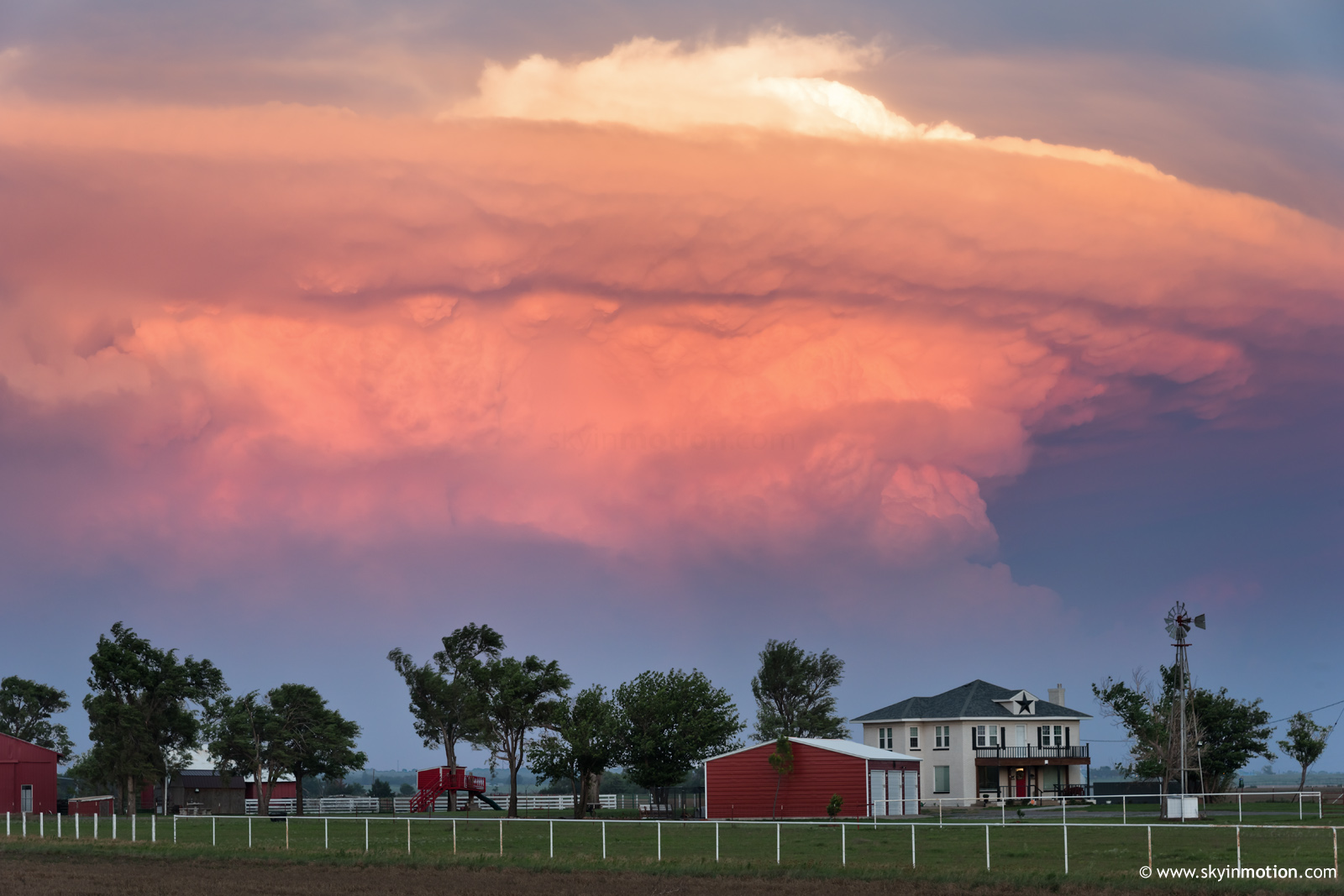
Incredible view of the backside of a tornadic supercell to the south of Saint Jo, Texas after dark. The view is to the southeast. Some of these storms were over 60,000 feet tall.
 

Despite questionable LCLs and low-level shear, I felt pretty good about June 15 near the TP given the compact, intense shortwave translating across an extremely unstable warm sector right at peak heating. I left after lunch for a target of Canadian, but by the time I was somewhere NW of Clinton, nuclear development was already underway to my S near Mangum. I admit I was torn and pulled over for a good 20 minutes mulling my options, but eventually pressed onward with the original plan, feeling the SW OK activity would outrun the true instability axis.

I eventually made it to Canadian, where I sat for another 20-30 minutes impatiently awaiting CI south of the OK Panhandle. New storms ramped up to my NW in earnest just before 5pm, but I was presented with an awful dilemma: both paved N options in the area N of Canadian (TX-23 and FM-1920) were torn up by construction, including pilot cars and the whole nine yards. This meant I had to commit to either (a) booking it NW toward Perryton on US-83, or (b) tucking tail and meandering NE on US-60, where I could take TX-305 toward Lipscomb. Basically, (a) meant being very aggressive and likely falling behind storms after a brief window, while (b) was the long-term play... like, really long-term, putting me more 30 miles downstream from (a).

As a chronic hedger, I of course went with (b) and reluctantly headed to Lipscomb. As anyone who saw national news that week already knows, I chose poorly. The only truly impressive and photogenic tornado of the day struck right in Perryton, and I likely would've made it in time to see some or all of it with option (a). Instead, I found myself driving in circles around Lipscomb, unable to glimpse even the base of the Perryton storm thanks to haze. Just before 5:30p, though, new convection unzipping down the dryline to my W intensified and a landspout was quickly reported.

I zipped W on FM-3260 toward TX-23 and quickly gained visual... and by then, there were twin landspouts. The southern (left in pics and video) one was clearly weak with little condensation between cloud and ground level; it dissipated within 5 minutes or so. The northern (right), on the other hand, went on for over half an hour. Although I never got any closer than about 8-10 miles -- as predicted, the Canadian River Valley Constructionpalooza of 2023 burned me about as badly as it could -- I still enjoyed a stationary view of this rather unique twister. It eventually developed a pronounced clear slot, suggesting it became some type of hybrid tornado.

2023-06-15_1361.jpg


2023-06-15_4833.jpg


2023-06-15_4852.jpg


Once the main tornado dissipated, the real fun began: convection continued to unzip to the S, quickly forming a large composite gust front that surged SE across several counties by sunset. I spent most of that period speeding S and E, never able to get back ahead of the most interesting circulations. What had been understandably projected as a menacing derecho rapidly began to re-descretize by 8:30p or so, then ultimately just kind of fizzled out after sunset. By that point, I was all the way down near Mangum... >100 miles from the landspout fest, and ironically where the storms I'd blown off at 3pm were birthed. Since some of the open warm sector storms were still rampaging on to my SE, I snagged a telephoto shot of one near Lawton with a ranch house in the foreground. I then completed the day's laughably circular route through Altus and Lawton, coming home from the SW on I-44.

2023-06-16_1381.jpg
 
Back
Top