John Farley
Supporter
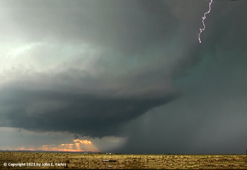
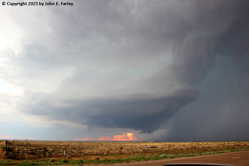
This was the second day of my four-day chase trip in eastern NM. Things were late to get going on this day, but when they did, after 6 p.m., the storms were pretty impressive. Two supercells formed quickly, one just north of Tucumcari and the other one to its northeast, to the northwest of Logan. I was closer to the latter one, so went for that one, northwest of Logan. These were very slow movers; once I got on the Logan storm I did not need to move more than a few miles over a period of perhaps an hour and a half, as the storm produced multiple reports of golfball hail northwest of Logan. This storm developed an impressive meso that looked like a giant top in the sky:
This storm also produced a very interesting feature which I am not entirely sure what to make of. The wall cloud was definitely rotating at the time, and below if a blob of condensation formed near the ground with a dust cloud underneath. Here is a video capture of that:
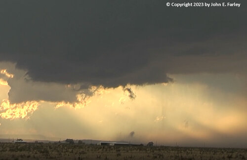
The condensation then elongated into a long, thin shape and rose about halfway to the base of the rotating wall cloud:
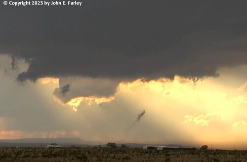
To me, this looked a lot like the ropeout stage of some tornadoes I have seen. Were it not for the fact that it was under a rotating wall cloud and started with a cloud of dust (which I was too far from to ascertain whether it was spinning or just blown into the air), I would probably discount this as scud, but given the location and appearance, I think it could have been a brief tornadic spinup. Here is a link to the entire video segment showing this feature, which lasted for about a minute and a half:
Logan, NM storm feature-possible brief tornado? - YouTube
There were a lot of chasers on this storm, although by the time the best stuff happened, many had relocated to the other storm closer to Tucumcari, which eventually produced hail up to 3.5 inches in diameter and, for the second straight night, a hurricane-force gust at the Tucumcari airport. Anyway, if anyone else was on my storm and saw the feature above, I would be interested in your take (or anyone's thinking based on my pictures and video). Eventually, as the storm drifted slowly south (I don't think it ever moved more than 5 miles an hour), I needed to move. I was originally planning on getting a place to stay in Logan, but since it now looked like this storm was about to hit Logan, I decided to try to skirt the back edge of the other storm closer to Tucumcari and get a place to stay there. I did get into some hail and needed to wait a bit for the storm to pass, but did make it to Tucumcari and got a place to stay. Then more fun arrived, in the form of a third supercell that popped up west of Tucumcari around 9:30 and drifted into town by a little before 10. Luckily the motel I was staying at had a couple of carports which were empty so I was able to move my car to safety in one of them shortly before the intense barrage of hail arrived. Much of it was dime to quarter-sized, but there were definitely a few golfballs mixed in. Here is some video I got of the hailstorm:
Hailstorm in Tucumcari, NM, 5/25/2023 - YouTube
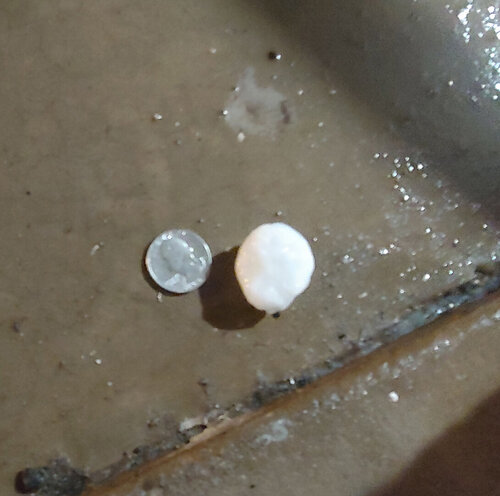
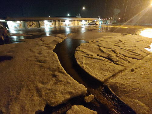
The hail lasted for probably 20-30 minutes and accumulated to a few inches in parts of the parking lot. Here is one stone I used a quarter to measure early in the storm; there were some bigger ones later:
Here is a picture of the accumulated hail in the parking lot:
When time permits, I will write up a fuller report and post it on my Web page along with a link in this thread.

This storm also produced a very interesting feature which I am not entirely sure what to make of. The wall cloud was definitely rotating at the time, and below if a blob of condensation formed near the ground with a dust cloud underneath. Here is a video capture of that:

The condensation then elongated into a long, thin shape and rose about halfway to the base of the rotating wall cloud:

To me, this looked a lot like the ropeout stage of some tornadoes I have seen. Were it not for the fact that it was under a rotating wall cloud and started with a cloud of dust (which I was too far from to ascertain whether it was spinning or just blown into the air), I would probably discount this as scud, but given the location and appearance, I think it could have been a brief tornadic spinup. Here is a link to the entire video segment showing this feature, which lasted for about a minute and a half:
Logan, NM storm feature-possible brief tornado? - YouTube
There were a lot of chasers on this storm, although by the time the best stuff happened, many had relocated to the other storm closer to Tucumcari, which eventually produced hail up to 3.5 inches in diameter and, for the second straight night, a hurricane-force gust at the Tucumcari airport. Anyway, if anyone else was on my storm and saw the feature above, I would be interested in your take (or anyone's thinking based on my pictures and video). Eventually, as the storm drifted slowly south (I don't think it ever moved more than 5 miles an hour), I needed to move. I was originally planning on getting a place to stay in Logan, but since it now looked like this storm was about to hit Logan, I decided to try to skirt the back edge of the other storm closer to Tucumcari and get a place to stay there. I did get into some hail and needed to wait a bit for the storm to pass, but did make it to Tucumcari and got a place to stay. Then more fun arrived, in the form of a third supercell that popped up west of Tucumcari around 9:30 and drifted into town by a little before 10. Luckily the motel I was staying at had a couple of carports which were empty so I was able to move my car to safety in one of them shortly before the intense barrage of hail arrived. Much of it was dime to quarter-sized, but there were definitely a few golfballs mixed in. Here is some video I got of the hailstorm:
Hailstorm in Tucumcari, NM, 5/25/2023 - YouTube
The hail lasted for probably 20-30 minutes and accumulated to a few inches in parts of the parking lot. Here is one stone I used a quarter to measure early in the storm; there were some bigger ones later:

Here is a picture of the accumulated hail in the parking lot:

When time permits, I will write up a fuller report and post it on my Web page along with a link in this thread.

