2022-05-30 REPORTS: SD/MN/IA/NE/KS

Matt Hunt

EF3
Joined
Aug 2, 2009
Messages
293
Location
Twin Falls, ID
Not a photogenic tornado, but nonetheless I did see a tornado over Lake Sinai, SD around 2:15pm this afternoon. It was the storm that got the first tornado warning of the day. I had just repositioned north of Sioux Falls to Colmon when the warning popped up. I figured I could beat it to Madison, and then go north on 81 alongside it. Didn't see much to the west as I crept north on 81, paralleling the area of rotation (only one out there, which was cool, but also a bit eerie!). As it got close to 81, I found a paved east option, which went to the tiny town of Sinai. Road curved to the north and went right by the lake. Now rotation was strong on a bowl funnel, and then I started seeing little rising whisps, and small vortices on the ground circulating the larger bowl. I thought I was about to see a wedge, but after moving north and then back east (it was actually tracking almost due east it seemed), the rotation had died, and it was all outflow. That seemed to be the theme of the day. Just short circulations, here one minute, gone the next. Nonetheless, I'll take it on such a difficult chasing scenario. Contrast enhanced video screen grab:Sequence 01.00_00_50_09.Still002.jpg
 
I left O'Neil Nebraska at 9am after chasing the day before and seeing the monster hail. Being from KC I hoped the DL looked better so I could chase back home. I felt like the DL was too conditional and I was already very close to the north target which looked better. We positioned to the NE of the storms that fired in Nebraska and stayed with those most of the day. We watched them try ish for a long time but eventually left them for the more "discrete" looking ones that formed in IA. As they IA storms moved NE I thought they would have a better chance of producing something. Well they did like the rest and disappointed. No photos worth posting for what ended up being a bummer of a day. I decided to not chase today and focus on work. To later chases ....
 
Targeted Willmar, MN in the hopes that multiple cam guidance was right with a pre frontal wave and supercells ahead of the main line. As soon as it became apparent this wasn't going to be the case we blasted northwest to Osakis to try to intercept the storm that produced the Forada tornado. On the way a storm initiated east of the Forada storm and I took a phone call from a friend on the Forada storm who said the only thing visible was rapid rotating rain currents and tree debris falling everywhere. A common theme from anyone who managed to get on tornadic storms yesterday.

So we got in perfect position to observe the eastern storm. Have never in my life seen storms moving that fast and of course everything was a hp mess. Our storm briefly looked decent as it approached I94 with a large bowl shaped lowering and a tornado report, and then in a matter of minutes everything lined out and the race was on to not be munched by nasty green cores and monster shelfs.

Ridiculous storm speed made it inpossible to set up and photograph anything, a couple cell shots out the window at a mean looking core as we raced southeast to avoid it.

20220530_170018.jpg

20220530_170021.jpg
 

Attachments

  • 20220530_170021.jpg
    20220530_170021.jpg
    50.4 KB · Views: 0
  • 20220530_170018.jpg
    20220530_170018.jpg
    40.7 KB · Views: 0
Started the day in Norfolk Nebraska after a fun filled chase the day before. Targeted SW Iowa after playing around with early day convection just West of Norfolk. The cams were were all showing action on the dryline at some point in the afternoon and they were right. Watched the first group of storms that drifted into Iowa for a while and then decided to drop down to the newer NW Kansas storms. We perched on a hill where we could watch the whole storm segment and saw a fairly brief wall cloud from a distance toward the back of the storm and thought we saw a funnel close to the ground there also, which was confirmed from someone else’s pic. That segment quieted down so we let it pass and set our eyes on the Topeka storms. Ended the day before fully getting on those storms when it became obvious it wasn’t gonna happen.
No pics to share because the only thing interesting was too far out for a decent pic.
 
I started the day in York, Nebraska. I initially headed down to Salina and it became apparent that the dryline was moving rapidly further east than forecast. I ended up meeting up with Gene Thieszen and we decided to target Wichita for the cells that popped up down on the southern end of the DL. There were consistent signals for this on CAMs as H5 support coincided with the boundary juxtaposed west of I-35. Storms intensified and rapidly became severe in the afternoon. We got on a cell northwest of El Dorado that had decent rotation, a nice wall cloud and numerous funnels. Once it became apparent that this storm was not going to be more photogenic and was becoming HPish, we dropped down and caught another severe warned cell southwest of El Dorado that had tracked east of Wellington. All in all, a great chase with at least some decent structure.
 

Attachments

  • PXL_20220530_233300446.PANO.jpg
    PXL_20220530_233300446.PANO.jpg
    272.5 KB · Views: 0
  • PXL_20220530_233323749.jpg
    PXL_20220530_233323749.jpg
    129.5 KB · Views: 0
  • PXL_20220531_001940017.jpg
    PXL_20220531_001940017.jpg
    88.3 KB · Views: 0
  • PXL_20220531_003058865.jpg
    PXL_20220531_003058865.jpg
    108 KB · Views: 0
Originally had planned on chasing the whole weekend, but as things got closer, each setup started looking more and more flawed....and with gas prices sitting where they are these days...I've gotta pick and choose. I ended up sitting Saturday and Sunday out and headed out for Monday. I wasn't impressed with the setup in Southern Minnesota/Northwest Iowa as I don't care much for meridional flow and it looked very messy and an early show.

We decided to target the dry line bulge there in Northeast KS/Northwest MO/Southwest IA. SPC was bullish early on with a 10% in this region for tornadoes so we were optimistic and the high resolution CAMs were persistent in showing supercells maintaining themselves from 23z to 03z into Northwest MO/Southwest Iowa.

We ended up documenting a couple marginal supercells in Northeast Kansas near Effingham and then in Northwest Missouri before heading home. The storm structure at sunset was the only thing that saved this from being a 735 mile round trip bust. Certainly not the day I was hoping for or expecting, but nonetheless we did get something out of it. Here are some stills:

_DSC5236.jpg

_DSC5562.jpg
If it had produced right here, this would have been a golden shot with the perfect road leading up to it. Was not meant to be....

_DSC5522.jpg
Wider shot at this supercell departed into Northwest Missouri and fell apart after dark. We got back home around 2am hoping for redemption the next day...however marginal it may be.
 
I would never have chased the Monday setup if not for taking my chances on Sunday. My storm hunger and time off won out over common sense. Monday looked like an obvious mess from two days prior, with rather terrible hodographs and storm mode expected (and verified).

I talked myself into this trip based upon the Sunday CAMs putting a few discrete cells just past the NE sand hills or maybe even as close to home as North Platte. Three discrete cells were widely spaced consistently for many runs, that morning. While storms west would be high based, it seemed worth a shot as I also had the intention of trying to shoot sprites that night on the stationary front. By the time my Sunday drive out was half done, surface observations and CAMs made it clear I'd have to get more north east for the only discrete storm that fired, practically at dark. I stayed the night in Ord after catching a glimpse of that storm and then escaping the circus of bad behavior.

Monday waking up, I knew with even more certainty I wanted nothing to do with the entire awful setup and mess of chasers who would pursue the bright flashy bullseye in MN and IA. I'm still surprised this event generated the hype it did, as the mix of parameters was not good. I cannot remember a single chase when too much CAPE, too little capping and meridional flow made for a good chase day. Regardless, already being out on the plains, I drove south down the dryline into KS to take my chances on something discrete. Eventually cells did become discrete. A few actually had passable veering with height. One down by Caldwell had a nice hook on radar, but there was just too little moisture for longevity and I was still too far north. Saw impressive echo tops of 65k indicated on radar for one cell southeast of Junction City on a couple frames.

The only photogenic thing I saw in two days was an LP cell near Dwight, KS. This was the middle cell of four discrete cells off the dryline. It had beautiful thunder sounds as it went directly overhead, and I could still hear birds chirping. The LP withered in under an hour, and the cells south began to also. The cell north clustered for a bit and became linear then also died. Called the chase by 7PM and made the long drive home.
4G7A6745-2.jpg


Captureeer.PNG


nvgjg.png
 
Really wasn’t planning on chasing since the storm mode looked like it was going to be QLCS all day, but the HRRR showed some supercells popping in the pre-frontal zone in central MN ahead of the main line. I bought into the solution and headed out the door towards west of the Twin Cities to the McLeod/Meeker County areas just after the PDS tornado watch was issued. Obviously, the supercells never popped, so I decided to get some photos of the line in western MN progressing eastward to make the chase feel worthwhile. Going after fast moving rain wrapped tornadoes didn’t interest me much. Stopped in Cosmos, MN and took photos. Saw some sort of lowering, perhaps a wall cloud, not sure. The feature was there when I got out of the car for pictures. Tried to stay ahead of the line, but got eaten by the storm with heavy rain in Dassel, MN and took cover under a gas awning at Casey’s. Fortunately, no hail. Storm weakened as it headed into the core of the Twin Cities metro where I was able to get out ahead of it again. Made it home in western WI and treated to a nice cumulus against a sunset backdrop.

I have to admit, I miss the classic supercell chases. Seems to happen more infrequently up in this neck of the woods. I don’t get to chase much, but when I do, it’s a far cry from any Hollywood film portrayal of storm chasing…lol.

7A0EEA70-A016-4E9C-85C3-F7B1323D7820.jpeg
43A97643-BA3F-432F-AEC0-36000EF99F50.jpeg
D1CFDF8D-CEBA-4EC3-9344-7078C5A54C42.jpeg
 
Memorial Day was the second day of my FIRST chase with my 10 year old daughter.
AND SHE'S HOOKED!!

I've chased for 15 years and once she was old enough, I would show some of my pics/videos. But she was always scared of thunder;)
Suddenly this spring, she started asking more questions and would always want to know if a big storm was coming when it was supposed to rain here, because she wanted to see one.
I was planning on chasing both Sunday and Monday and now that school is done and the Sunday chase looked to be a close one, I asked her if she wanted to come with and she eagerly said yes!
I'm going to throw in a bit on Sunday before I get to Monday, rather than starting a separate 5/29 reports thread if that's okay.
We left Omaha mid afternoon 5/29 and went to the Norfolk area to wait for storms. I was worried this would be a big bust and on her first day.
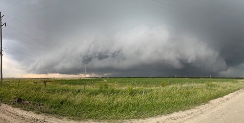
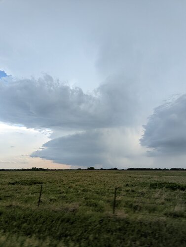
Even though it was much further west, we made a break for the storms that were forming. We arrived shortly after 8 to the storm west of Taylor. She was so excited to see a big, mean looking supercell! We watched it for a bit as it moved away to the northeast and had to backtrack due to the poor road network. We caught back up with it as it crossed the highway north of Taylor, initially only driving right up to the storm to avoid the hail.
Once it crossed the highway, I immediately began looking for big hail in the ditches and not more than a couple miles ahead saw the first stones. I pulled over and hopped out of the car to my daughter asking, "what are you doing? You're going to get wet!!"
I ended up finding multiple 2+" stones and one that was 4.5". This was the largest hail I've ever seen in person. We took some pics and headed on again having to drop back south to be able to go north again and try to catch back up with the cell. All the while my daughter was recording video to use for her "vlog" she wants to do on my chases.:p
We made it to Yankton, SD where my parents live to crash there for the night before the chase on Memorial Day. We arrived just ahead of the storms approaching and within 30 minutes, Yankton was under a tornado warning. I woke my parents up and we all hung out in the basement while the storm passed with no touchdown thankfully.

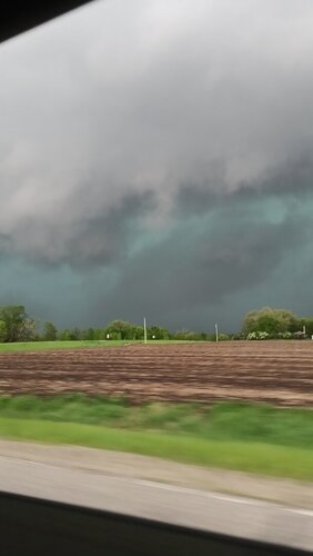
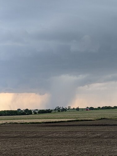
We left Monday morning and headed north to Brookings. Storms were already forming into a big mess to our west, but were beginning to show some areas of rotation along the leading edge. We went west of the town of Volga and waited for the storms to approach as we were now under a tornado warning. I counted 3-4 small couplets on the leading edge and one of them was approaching our location. There was an extremely "violent" roll cloud that came over us, and to our south a few miles you could see a nice lowering. Soon a nice funnel dropped down for about 20-30 seconds, but immediately lifted back up.
At this point we headed east into Minnesota as a nice looking storm on radar was out ahead of the line a bit. We got ahead of this storm, but it was soon absorbed by the main line. Upon stopping in front of the storms, the air was cold (~58 degrees) and there was strong outflow. I was almost ready to call off the chase.
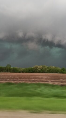
I decided to give it a bit more time though and we continued east ahead of the line. In my rearview mirror it began to look better with a nice shelf cloud on the leading edge of pretty green core.
I decided to stop again and at least get some pics of my daughter in front of the storm as my wife wanted me to take lots of pictures. Upon stepping out of the car, I was much more enthused. It was warm and muggy with decent inflow into the line that still just to our west. We observed an area of concentrated rapid rotation on the leading edge just to our southwest.
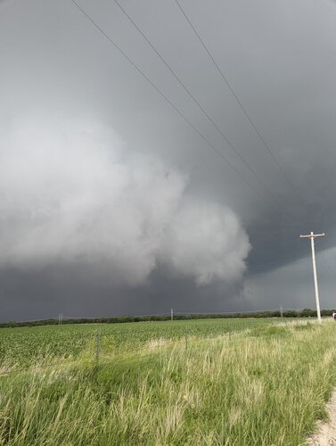
The line was almost on us within a couple of minutes so we hopped back in the car and started heading east down the highway. We were going 70 mph and were barely getting ahead of the leading edge of the storms. As we were driving, I was looking out the windshield directly above us to watch all the chaotic motion of the leading edge. I soon noticed an area that was rotating pretty good and sure enough started to see a nipple funnel start to form about the time it disappeared from view over the car.
Suddenly, the inflow winds increase dramatically out of the southeast and rain curtains were flying across the road and fields. Up ahead a short distance was a grove of trees and we observed a rather large section of one of the trees go toppling over in the winds. I realized we were directly in front of a developing tornado!
As we passed the grove of trees you could see multiple branches down in the road. The strong inflow winds continued and I didn't want to stop too soon and was unable to see much behind me for any kind of ground contact.
A short time later, my daughter commented that it felt like her ears had to pop, which of course is a common sign of a tornado passing very close. I told her what that meant and she was like "woah!"
A new tornado warning came out shortly thereafter as the line raced northeast at 65-75 mph. We decided to drop southeast to get in front of one last area of storms that were just ahead of the main line, but nothing much was happening with those, so we started heading about 530p arriving in Omaha just before 10p.
She was quite the trooper as we put on almost 1000 miles over 2 days. Even though both days (especially Monday) "underperformed", I fee like we got the most out of our chase. Everything was a first for her of course, and for me I had never seen that large of hail before, and never had a tornado forming that close to me either.

I put together a short video from Monday's highlights:

storm.jpeg2.5 hail.jpeg4.5 hail.jpegPaige.jpeg
 
Most chase vacations have an "alleged big day," and this was (supposed to be) it. Judged by conventional measures, this one was a disappointment, as so many "alleged big days" are (hence the qualifier "alleged"...) If I was chasing alone or with my usual chase partner, I would have spent most of the day irritated and pissed off. But this being my first chase vacation with my son, I look back on it as a memorable day in which he got great exposure to many aspects of chasing: numerous different atmospheric visuals, a lot of chase logistics given intercepts of six different supercells (notwithstanding all of them shriveling up to nothing) and, yes, the vagaries of the weather and its resulting frustrations. As a side note, I have historically avoided eastern KS due to terrain considerations, but I found the scenery E/SE of Salina to be quite picturesque.

Perhaps I shouldn't have expected too much today, having already chosen to pass on the primary SD/MN target in favor of the secondary KS target. I really had no interest in taking such a long drive up north, especially given potential failure modes including meridional flow, storm interference, and morning convection. Very fast storm motions, potentially into the unfriendly chase terrain of northern MN, were additional negatives, as was not wanting to be out of range for the next day's activity back in the southern Plains. With hindsight, definitely no regrets in choosing KS over SD/MN, despite the ultimate lack of tornados in KS.

The next decision was northeast KS vs southcentral KS. Beginning the day in Hastings, NE, my plan was to get to Salina and then decide whether to head east from there, or southeast to a target northeast of Wichita. Ultimately decided on the latter, and set a target of Strong City. An SPC MSD came out highlighting northeastern KS, causing me to second-guess myself, but I resisted the temptation to change course, reminding myself of how many times I have been swayed by MSDs to my detriment, especially since it's often just a question of timing, as subsequent MSDs often verify the original target anyway. Nonetheless, I still hedged a bit, by first going east, before dropping south... This would also put us more quickly on the appropriate side of the dryline... We stopped at Herrington to check data again before going south and, sure enough, saw a new MSD that now included southcentral KS. To make things even better, a cell was going up right on top of me in Herrington.

We went after this cell, but got road-screwed by construction closures, resulting in a big waste of time and a big detour. By now, the convective development in this area didn't look good anyway: they were congealing into a thin line from Parkerville to Saint Mary's. Perhaps because the mid-level flow was too parallel to the dryline?

We dropped south closer to the Strong City target. A line of storms from up through Florence didn't look any better than the ones we had left. I was already becoming pessimistic about the day's prospects, but at least heading south would push us toward the next day's target in the Texas Panhandle. This line of storms was oriented NE-SW. My plan was to drop due south, through the northern end of the line to get to the southern cell.

Gradually these storms started to show more separation. We ended up behind a developing appendage on one storm - I was inching behind this storm on a road heading NE out of Cedar Point, hoping it would clear the E/W road that went to Emporia so that I could drive east along its southern flank. I saw possible signs of developing rotation on radar, but there was never a TOR warning. We made it to Strong City, but we couldn't continue east from there because the storm was still blocking the road and would have required a hook slice. It was looking weaker on radar anyway, so I decided to drop south to the next storm that was near Burns. We drove SW on a road paralleling I-35, driving through Bazaar, Matfield Green and Cassoday, through some very heavy rain at times. This road turned very hilly and tree-lined, offering only brief views of the updraft base, which was to our SW. There was one scenic overlook pull-off, where there were a bunch of other chasers parked. The following photos were taken there - these were the first decent pics of the day, although the storm appeared to be gusting out.

File Sep 12, 10 28 38 AM.pnggood structure 2 AM.png

So now we dropped down to the next storm, an isolated cell near Douglass, just SE of Wichita. By the time we got there, this storm, too, was dying, and the SVR warning had been dropped.

Wanting to get south for the next day anyway, we made one final attempt, toward a storm near South Haven, close to the OK border. This was another isolated storm, which looked like it had a hook on reflectivity but to my knowledge was never TOR-warned. By the time we got to it, this storm, too, had died. Another chaser texted me that there had been a brief stovepipe tornado report, I think he said near Arkansas City KS, but even as I write this in September there are NO Kansas tornado reports for May 30 on the SPC site.

We drove to Ponca City to stay for the night.

The shrinking updrafts provided some unique visual perspectives; they were almost like miniature storms, providing a good opportunity to highlight for my son how the anvil spreads out from the updraft tower. There were still some nice visuals throughout the day, including a full rainbow, and some great colors as the sun set.

nice clouds AM.png


shrinking towerAM.png


shrinking 2 AM.pngcolors AM.pngrainbow AM.png
 
Back
Top