2021-10-12 EVENT: KS, OK, TX

Joined
Feb 19, 2021
Messages
632
Location
Wichita
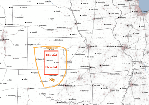
I'll go ahead and kick things off tonight. My forecast is nearby. I use a four-category scale: Significant, Elevated, High and Extreme.

If there was more moisture, and because this will be at night, I would be forecasting a High risk. A negatively tilted trough is always a favorable synoptic environment. Many of the CAMs are forecasting supercells ahead of the primary line which will probably be the cells most likely to produce.

If you decide to chase, DDC is a very good place to start. There are good motels there and in PTT with good roads in all directions from both cities.

Stay safe and good luck.
Tornado Forecast 10-12-21 1055p.png
 
If I were retired I probably would have been out on the Plains taking a mid-season flyer on Sunday and today, but as it is I'll be watching from home in Pennsylvania.

Surprised to see the SPC upgrade, from the overnight outlook's 5% tornado risk to this morning's 10% and hatched area. I did not do a full analysis this morning, but based on a cursory review, if I were out there, I would initially target Shamrock. Most models have trouble getting moisture too far up into Kansas, and some barely to the OK/KS border; in contrast, the RAP seems quite bullish in getting moisture further north. Regardless, there appears to be a dryline punch toward Childress, with the deeper moisture wrapping into western OK and the eastern TX panhandle. 500mb winds seem somewhat more orthogonal to the dryline in this area, vs north into KS. Some great directional shear, low LCLs, etc. Concerns are early showers/convection and reduced instability from the strong large-scale forcing, potential lack of moisture depth and its relatively late arrival (the best events always seem to have moisture in place further in advance) and timing relative to sunset, given the shorter days.
 
Upon looking at the newest data, based off the CAM's, I'm guardedly optimistic that there will be some storms worthy of pursuit. The biggest negative for this event, is that most of the action will be after sundown. During the day, warm air advection with abundant moisture transport will prime the atmosphere as the afternoon progresses. Scattered, somewhat elevated cells may develop over western into north central Oklahoma with marginally severe hail and wind gusts. SRH values will steadily increase and become maximized during the mid and late evening hours when the more robust cells develop. Just now seeing the 12Z HRRR, I think it's safe to predict that some of the strongest cells will be in western Oklahoma between the 0Z-04Z time period where cells have the best chance of staying discrete before evolving into a QLCS with loops and bows as it progresses towards the I-35 corridor north of I-44. Further north, while shear values will be more than adequate, cells will morph into a more rapidly propagating line segments across parts of western into southwest and south central KS. Higher cape values and a slightly longer period of discrete cells should occur in Oklahoma, hence my target area if I go out would be in the Clinton, Weatherford to Hinton, OK. region. The cold front should then be racing east with an attendant squall line that should be slowly weakening as it approaches I-35 by the 06-09Z time frame. Chief hazards for this event will be damaging wind gusts to 75kts, hail up to 2" diameter, and a few QLCS vortex's and perhaps one or two brief, but strong EF-2 tornadoes for Oklahoma. In Kansas, slightly less favorable conditions for tornadoes, but the threat will surely be there. Be safe if you go out. Like on 10/10, this evening won't be for the more inexperienced.
 
I'll go with the southern half of Mike's area marked Elevated. Note his post was last night. Reasoning includes boundary and moisture return.

First of all, we all see the JIT just-in-time moisture return. It means JIT CAPE too. However the kinematics and wind shear is more than enough. Modest CAPE and high shear, going into evening, is well known in Dixie Alley. Gets less attention in the Plains, but academic papers on the subject include Plains events. The modest CAPE high shear set-up works just as well in the Plains.

The JIT situation is why I pick the southern half of the Elevated box. Boundary also appears near the Kansas border. It's possible the tail end of the line (most CAMs) in the Panhandles (OK/TX) becomes a chase area. Otherwise the boundary should barely make it into Kansas.

HRRR blasts OKC but it has 5/20/19 vibes. SPC does not seem concerned; however, yet another boundary will lift north from the Red River into central Oklahoma. Forcing and CAPE are lower than that farther northwest; however still there, and some LI lurks if near surface based CAPE can materialize.

I'd have a good sit-down lunch and monitor data from a place like DDC, GCK, Greensburg or Pratt. Woodward is a nice hedge if one is concerned about central OK. However I'd be more inclined to move west from lunch. Perhaps initiation from Garden City KS to Canadian TX. Might take a bit for storms to root and rotate, so follow from there - especially a sup on a boundary.

Late timing is a challenge. However that whole area is some of the best chasing in the Plains. Of course it's worth a try!
 
If I were chasing today (which I am not, I chased yesterday and will probably chase tomorrow lol)....I'd probably pick to be in Western Kansas. I think that is the best bet for storms firing before dark. I'd pick to be on the nose of the theta-e and moisture advection as well where 0-3km CAPE is relatively high along with 300-500 SRH, I think a few strong tornadoes are in the cards anywhere from as far north as Colby, KS down into the Panhandle/Western OK in the presence of a 55+ knot low level jet.

So my preliminary target for 7pm this evening would be Garden City., KS from 7-10pm this evening for the possibility of several long track supercells with strong (EF2+) tornado potential and very large hail (2-3"+). You have good options to get north or south there if need be. I could see myself heading north for initial development or south for secondary development after sunset depending on timing of moisture and instability (ie. where that nose of theta-e advection ends up).

A secondary target would be down in Western OK/Eastern TX panhandle where moisture return should occur sooner and storms may be a bit more questionable on firing early on, but almost certainly will fire later on this evening toward 02z and likely last through the overnight hours. I think this is probably the most legit nocturnal tornado threat we have seen on the plains since November 16, 2015. I would be shocked if there wasn't a respectable tornado or three by morning across the high plains. Luckily the threat isn't another 100 miles further E along the I-35 corridor in a higher populated area. Hopefully tornadoes can stay in open areas and not impact towns.

While I think both targets will pan out, I think the Kansas target might have the best bet at initiation slightly before sunset, and who knows maybe someone will get a daytime tornado. If I remember correctly, the 2015 event wasn't supposed to start until after dark and there ended up being a few nice tornadoes in Western/Northwest KS prior to sunset or right at sun down. Good luck to everyone!!
 
June 8, 1974, at WKY TV in OKC (now KFOR) we put one of the then giant studio cameras onto a tilted loading ramp and, for the third time in history, broadcast a tornado live. I knew that, as meteorology and technology progressed, we would capture more and more live tornadoes for warning purposes.

But, I never anticipated what I saw from southwest Kansas last night. KSN (NBC, Wichita) meteorologist Erika Paige chased a QLCS tornado moving at 60 mph and televised it live from the KSN storm tracker vehicle. A short version of the coverage is here: Recap of Last Night's Storms

We live in an amazing world we often don't fully appreciate.
 
Any chase reports from last night? The supercell southeast of Elk City OK looked pretty good on radar at around 7pm CDT, looked much more classic than HP. There was a tornado warning at the time, but don’t think there was a tornado on the ground. Still, I imagine the storm would have had pretty good structure. Would have been getting dark by then but maybe it was visible enough in the low light, or maybe looked good earlier than that before dark…
 
There was quite a bit of tornado damage at the Clinton-Sherman (KCSM) Airport. I believe that was from the same supercell.


Any chase reports from last night? The supercell southeast of Elk City OK looked pretty good on radar at around 7pm CDT, looked much more classic than HP. There was a tornado warning at the time, but don’t think there was a tornado on the ground. Still, I imagine the storm would have had pretty good structure. Would have been getting dark by then but maybe it was visible enough in the low light, or maybe looked good earlier than that before dark…
 
Back
Top