Rocky Rascovich
EF4
Hello fellow Stormtrackers! It's been way too long since I last posted on here. the following is what I posted on other social media platforms and thought it's past time I contribute on here.
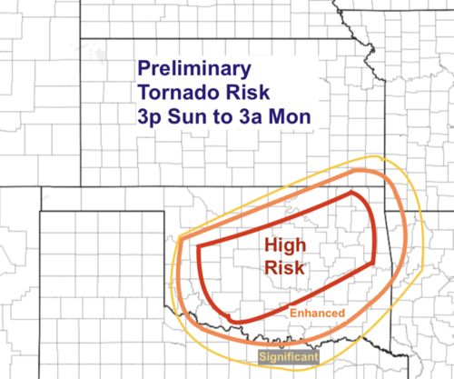
Most likely one of the best set up's of the entire year expected to unfold across the southern plains; specifically Oklahoma during the late afternoon thru the overnight period for much of Oklahoma, south and east of a line from GAG to PNC on to the DFW area. Currently, deep moisture currently advecting northward from the GOM will firmly be in place by the 23Z time frame, setting the stage for discrete convection to initiate over the east and southeast sections of the TX. PH., close to where the surface low should be located with a 998mb. surface pressure; a fairly respectable system for this time of year. Accompanying this strong short wave is a stout 80-100kt. 500mb. jet streak, overall cape values in the 1000-2500 j/kg. range, not to mention bulk shear values of 50 knots or so. All the ingredients coming together to manifest all modes of severe weather. The chief negative I see here is that severe parameters would be maximized just after sundown, so with loss of diurnal heating, this could have a mitigating effect on the severity of storms. Still, with all the dynamics associated with this strong short wave, explosive discrete cellular growth will be most likely in the CDS region on into SW Okla. If the NAM nest verifies, a 2-4 hour period of rapidly moving cells with strong vorticity tracks will move northeast into south central and perhaps central OK. by the mid evening hours before quickly congealing into a QLCS system where quick spin up TOR's won't at all be out of the question. I think the chief threat will be intense wind gusts due to downward momentum from the jet streak for cells to tap into. As the evening progresses, tornado threat may decrease but widespread SVR gusts will be common, along with hail up to 1.5", but I would not be surprised to hear of close to 3" hail in the most robust updrafts in SW. Okla. Unfortunately, from a chaser's perspective, the best of everything happening will be around dusk into the evening hours.. so chasing these storms could be a challenge, not to mention the mounting anxiety of the general public being this will largely be an evening/night time event. I'll be surprised if there is not at least 3 or 4 confirmed TOR's that will make haste in a northeasterly direction at 45kts or better. Maximum wind gusts of 80 knots are also possible. I will be chasing this, and my initial target will be the AXS area by around 23Z then adjust from there. Ground zero area for the most intense activity would be the Wichita Mountain area up to possibly the Fort Cobb Lake area. I'll be eagerly awaiting future runs of the NAM and HRRR runs as any deviation to the north could put the greater OKC area and my humble abode near Piedmont in the crosshairs. I hope there is some good feedback from those of you far more experienced in forecasting than I.
Most likely one of the best set up's of the entire year expected to unfold across the southern plains; specifically Oklahoma during the late afternoon thru the overnight period for much of Oklahoma, south and east of a line from GAG to PNC on to the DFW area. Currently, deep moisture currently advecting northward from the GOM will firmly be in place by the 23Z time frame, setting the stage for discrete convection to initiate over the east and southeast sections of the TX. PH., close to where the surface low should be located with a 998mb. surface pressure; a fairly respectable system for this time of year. Accompanying this strong short wave is a stout 80-100kt. 500mb. jet streak, overall cape values in the 1000-2500 j/kg. range, not to mention bulk shear values of 50 knots or so. All the ingredients coming together to manifest all modes of severe weather. The chief negative I see here is that severe parameters would be maximized just after sundown, so with loss of diurnal heating, this could have a mitigating effect on the severity of storms. Still, with all the dynamics associated with this strong short wave, explosive discrete cellular growth will be most likely in the CDS region on into SW Okla. If the NAM nest verifies, a 2-4 hour period of rapidly moving cells with strong vorticity tracks will move northeast into south central and perhaps central OK. by the mid evening hours before quickly congealing into a QLCS system where quick spin up TOR's won't at all be out of the question. I think the chief threat will be intense wind gusts due to downward momentum from the jet streak for cells to tap into. As the evening progresses, tornado threat may decrease but widespread SVR gusts will be common, along with hail up to 1.5", but I would not be surprised to hear of close to 3" hail in the most robust updrafts in SW. Okla. Unfortunately, from a chaser's perspective, the best of everything happening will be around dusk into the evening hours.. so chasing these storms could be a challenge, not to mention the mounting anxiety of the general public being this will largely be an evening/night time event. I'll be surprised if there is not at least 3 or 4 confirmed TOR's that will make haste in a northeasterly direction at 45kts or better. Maximum wind gusts of 80 knots are also possible. I will be chasing this, and my initial target will be the AXS area by around 23Z then adjust from there. Ground zero area for the most intense activity would be the Wichita Mountain area up to possibly the Fort Cobb Lake area. I'll be eagerly awaiting future runs of the NAM and HRRR runs as any deviation to the north could put the greater OKC area and my humble abode near Piedmont in the crosshairs. I hope there is some good feedback from those of you far more experienced in forecasting than I.


