MODS: Please add PA to the thread title.
No good visuals to share so I'll tell the story using radar images - which are also cool in their own right, given the rarity of such signatures around here.
I live in Bucks County PA and never take chasing seriously around here. I am never too optimistic about bonafide discrete supercells or tornados around here. Even if they were to happen, there are too many hills, buildings and trees to see anything, and too much traffic to be able to navigate around. I was bummed out missing the 7/29/21 outbreak in my home area while I was vacationing at the NJ shore (there was one tornadic storm that did strike the coast about 10 miles north of where I was at the time, but it was after dark so I did not go after it and watched the lightning from a distance).
After seeing what happened on 7/29, I was not about to totally dismiss the tornadic potential, but I still didn't expect much more than brief spin-ups of the type usually seen in tropical systems or their remnants. I had neither the time nor the motivation to analyze the situation too closely. I was at work in Lakewood NJ (which is near the NJ shore) and just figured I would see what I could see, not try to actually target any specific area. My route home was along Interstate 195, which was roughly the location of the warm front in NJ, although it then arced to the southwest on the Pennsylvania side of the NJ/PA border.
I left Lakewood at 4:15pm. Sometime between 5:00 and 5:30 I got off of I-195 and went south on I-295, which parallels the Delaware River on the NJ side. I pulled off at a scenic overlook and thought of heading south where there were some early tornado warnings roughly on a latitude of Wilmington DE if I remember correctly. I remember one storm looking really small and weak on reflectivity but still having a warning. Anyway I decided I just didn't feel it was worth it to drive 60-90 minutes for storms around here (probably longer given rush hour traffic and heavy rain) and I would just head on home and just take whatever happened nearby.
While continuing on toward home, back on I-195 toward and through Trenton NJ, I saw a strong couplet with one purple pixel that was clearly a debris ball, given its location and lack of hail anywhere else. It was coming up through the Fort Washington / Ambler PA area, where a tornado has since been confirmed. Radar image below:
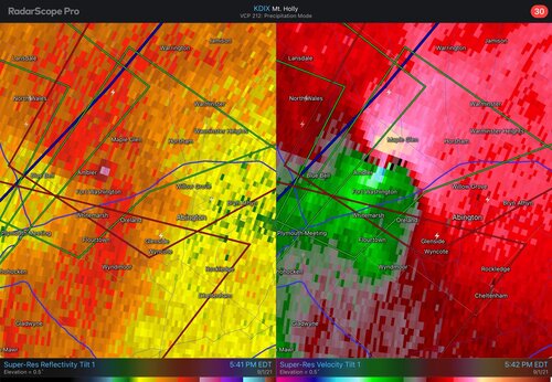
My home in Newtown was in the path, as shown below. I was pretty sure the storm would pass NW of Newtown but there is always the possibility of a right turn so for the first time I called my wife and told her to take the kids in the basement. You can see my location here, I have not yet made it all the way back home.
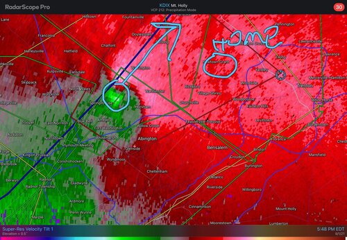
I passed my own neighborhood - by now it was out of danger from the circulation - and tried to intercept the storm driving up Route 413 toward Furlong and Buckingham - a touchdown was confirmed in this area - but you can see I am still SE of it at this time. I was in heavy rain and ponding was beginning on the road.
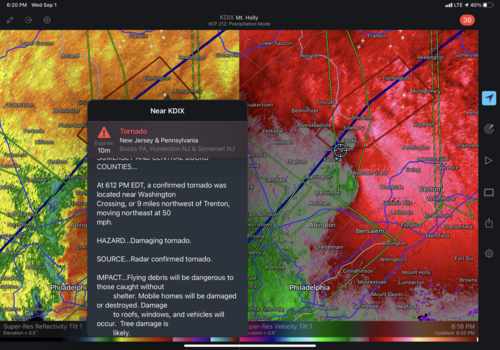
20 minutes later, the circulation is weakening as I approach Lahaska and a larger touristy shopping area called Peddlers Village. Meanwhile, a new circulation is developing to my south, this one on an even closer trajectory to my neighborhood near Newtown Grant. As you can see below, there is not yet a tornado warning on it. I called my wife again to make sure she was still in the basement (not sure if I made the call before or after the warning came out). Note in the below warning that is displayed, for the storm I was on, I believe NWS Mt. Holly was off in its stated location of this tornado. Washington Crossing is not visible on the map but it is along the river (white line) just NE of Newtown Grant; it was not even in the polygon.
At this point I was more interested in the new circulation to my south, but I was not in good position. It was heading NE and would cross the river. As with any river, there are only a few crossings. I decided to use the one closest to me (the Route 202 crossing, north of New Hope PA), even though it would keep me north of the circulation. Otherwise I would have to head south on a road that ran right along the river and through a town that was always congested and susceptible to river flooding. The rainfall rates were so extreme, I could barely see several feet in front of me. No exaggeration, I would not have even been sure I was on the correct road if not for my GPS. I kept saying to myself, where the heck is this bridge?!? It seemed to take forever and I barely knew where it was until I was actually on it (and, of course, this is all my local turf, roads I know very well...) As long as there was a car in front of me to gauge water depth it was OK, but when I became the lead car it was scary. On the NJ side, driving on Route 202, I hit a pretty deep area of water before I could even see it; maybe it was just because it was startling, but I really thought the car was going to float. I never expected the water to get that deep from rainfall alone, i.e. no river or creek nearby.
In the image below you can see where I was relative to the circulation, as I drove back south on Route 31 in NJ. The roads were getting very badly flooded; there was one intersection where there was so much water, and a police car parked; I feared the road was closed, and I started worrying about how I would get home. I was able to make my way through the water, but I gave up pursuing this particular storm; if this main road was this bad, what would the other roads be like? Also in the image below, you can see a new tornado warning to my SSW that includes Bensalem PA, which was hit by an EF-3 on 7/29/21.
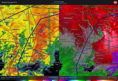
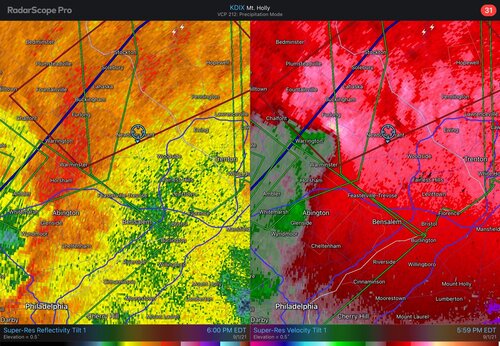
About 20 minutes later, the couplet to my SSW has strengthened and a new tornado warning was put out far ahead of it, given a forward speed of about 40 mph. I am in the NW corner of this new polygon - you can just barely make out the edge of the blue circle marking my location at the very top of the radar.
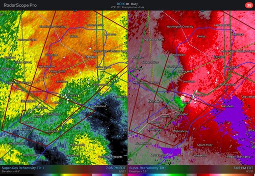
The blue road just above Ewing NJ on the map above is Interstate 295, which loops around Trenton. I was still heading south on Route 31, toward this highway. I briefly considered taking I-295 east, following the loop down around the east side of Trenton to intercept this meso (based on where it ended up, that would have been too far east, it would have been better to continue south, past I-295). But by 7:30 it was getting dark, the flooding was getting worse, and I decided to bail. When I got to 295, I went west instead of east. It was only a few short exits back to the PA side, and the exit for my town.
While I drove in insane rainfall rates that I have previously experienced only in Plains supercells or severe MCS's, I experienced little in the way of wind.
In retrospect, this "chase" had a very unfavorable risk/reward ratio - i.e., the dangers of driving in a populated area in heavy rain with flash flooding, with very little chance to see anything, because the circulations I was on were totally embedded deep in the rain. The later cell coming up from the south in the last image may have had more visibility, given its location on the southern edge of the precip. I think this was the same supercell that spawned the Mullica Hill NJ tornado, but I'm not sure (be sure to search for video of the Mullica Hill tornado; if you didn't know what you were seeing, you would feel absolutely certain you were looking at an Oklahoma tornado).
I spent over two hours making a circle that was about 35 - 40 miles in diameter, never able to catch up to anything due to the road conditions (and would I have been able to see anything, even if I had caught up?)
I was confident enough driving in the heavy rain given all my years of Plains chasing, but there were a couple close calls with hydroplaning and/or the guy in front of me stopping short. But my main fear was not falling victim to an accident or flash flood, it was simply that I would be unable to get home because of road closures and would have to sleep in the car.
In retrospect, I wish I had done more of an actual targeting analysis, and had headed down to the southern portion of the risk area in extreme SE PA / SW NJ.
Suffice to say my wife wasn't too happy that she was home in the basement with the kids while I was out jerking around. But for the first tornado I wouldn't have made it home in time from work anyway, and it looked like it would safely pass NW of town. I didn't expect there would be a second one immediately to its south (not sure if that one was ever a confirmed touchdown anyway). Let's face it, even within the polygon there is a very small probability that a given neighborhood, block or house is going to actually be affected by a touchdown.
I am still trying to make sense of this mini adventure and such an extreme event for this part of the country. I thought 7/29/21 was a "once in a lifetime" event for these parts, yet here was another one, a little more than a month later. Although I didn't actually "see" anything, I am glad I had the chance to be out there, engaged in the event, rather than just sitting it out at home. But I still feel a similar sense of regret as in any Plains chase, where you miss the "storm of the day." Especially given how rare such an event is around here, I wish I could have really optimized my own experience with it. But I am blessed to also be a Plains chaser, meaning I don't have to rely only on rare events around here, and have the ability to go where the action is each spring.


