JamesCaruso
Staff member
After 25 years of Plains chase vacations, yesterday was only the first or second time that I actually took the trouble to do a local chase. I have gone after storms in progress close to home on a nowcasting basis before, but never bothered driving to a target area around here, assuming nothing was likely to be worth the drive, or be visible with hills and trees, or navigable with traffic. But this day featured some good parameters - HRRR was actually generating some PDS TOR soundings. The main questiin was moisture, with a drying trend during the day and a just-in-time resurgence of moisture expected relatively late in the day, possibly only an hour or so before dark. A strong squall line on the cold front was a pretty sure bet, but I was hoping for an isolated supercell ahead of the main line. HRRR was showing an isolated cell blasting across southern NJ on multiple runs.
I was not bullish enough to be up for a huge drive, and I was hoping to stay close enough to home to be back around 8pm or so, especially if I targeted south and chased back a northeastward-moving storm. It was a completely different chasing strategy than on the Plains - not trying to be in the area of initiation, but just staying far enough east to give the 50-mph storms a wide berth and to stay east of cities like Wilmington DE and Philadelphia. It was more of a case of “I’ll drive a reasonable distance to see what I can, but I’m not going to commit the whole day and night to this.”
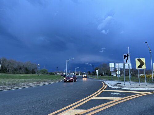
I drove down to Hammonton in south Jersey to get into the better moisture and hoping the HRRR model would prove correct with the discrete cell it consistently showed coming up out of Delaware and flying across south Jersey.
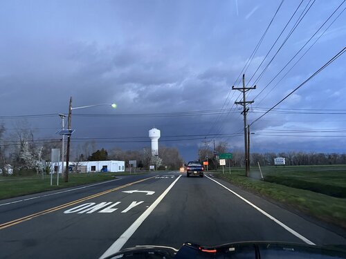
Radar showed several cells coming up out of Delaware and moving northeast, but they all fizzled out, except for one early cell that was a little more south in Delaware and turned right, producing a confirmed, damaging tornado. By around 6:30 or 6:45 EDT the latest cell moving northeast from DE into NJ wasn’t doing anything and there was nothing else to its southwest in DE, and the main line was getting close, so there was little remaining hope for a discrete supercell ahead of the line. It was time to head back home, hoping that maybe this last crappy cell would strengthen and maybe I could intercept it on the way home; based on its trajectory, I was thinking maybe around Willingboro NJ.
As I drove north on route 206, I noticed my area back home in Newtown PA was under a TOR warning. The velocity couplet looked very close to home and sure enough the text said Richboro, the next town to the south. I called my wife and told her to get the kids and go in the basement. I’m sure she thought I was a complete a$$ jerking around down in south Jersey while there was a TOR warning back home that she was now dealing with it without me there. The warning was later updated to actually cite Newtown as the location, I couldn’t believe it…
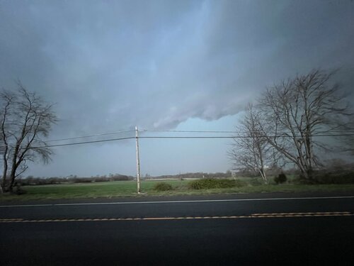
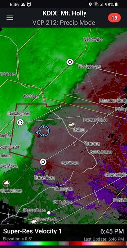
Anyway, I was soon in a TOR warning polygon of my own, that I was thinking I could intercept near Mt. Holly (where the Philadelphia NWS office is located) from my then-location in Tabernacle NJ. But the rotation dissipated, so I just allowed the line to run over me and drove home, while marveling at the hook that appeared to be curling in on itself as the northern embedded supercell moved east toward Jackson NJ and eventually off the coast.
Although I never had much realistic hope of seeing anything cool, it was a great feeling to hop in the car for a chase, and the first spring thunderstorm is always awesome.
I was not bullish enough to be up for a huge drive, and I was hoping to stay close enough to home to be back around 8pm or so, especially if I targeted south and chased back a northeastward-moving storm. It was a completely different chasing strategy than on the Plains - not trying to be in the area of initiation, but just staying far enough east to give the 50-mph storms a wide berth and to stay east of cities like Wilmington DE and Philadelphia. It was more of a case of “I’ll drive a reasonable distance to see what I can, but I’m not going to commit the whole day and night to this.”
I drove down to Hammonton in south Jersey to get into the better moisture and hoping the HRRR model would prove correct with the discrete cell it consistently showed coming up out of Delaware and flying across south Jersey.
Radar showed several cells coming up out of Delaware and moving northeast, but they all fizzled out, except for one early cell that was a little more south in Delaware and turned right, producing a confirmed, damaging tornado. By around 6:30 or 6:45 EDT the latest cell moving northeast from DE into NJ wasn’t doing anything and there was nothing else to its southwest in DE, and the main line was getting close, so there was little remaining hope for a discrete supercell ahead of the line. It was time to head back home, hoping that maybe this last crappy cell would strengthen and maybe I could intercept it on the way home; based on its trajectory, I was thinking maybe around Willingboro NJ.
As I drove north on route 206, I noticed my area back home in Newtown PA was under a TOR warning. The velocity couplet looked very close to home and sure enough the text said Richboro, the next town to the south. I called my wife and told her to get the kids and go in the basement. I’m sure she thought I was a complete a$$ jerking around down in south Jersey while there was a TOR warning back home that she was now dealing with it without me there. The warning was later updated to actually cite Newtown as the location, I couldn’t believe it…
Anyway, I was soon in a TOR warning polygon of my own, that I was thinking I could intercept near Mt. Holly (where the Philadelphia NWS office is located) from my then-location in Tabernacle NJ. But the rotation dissipated, so I just allowed the line to run over me and drove home, while marveling at the hook that appeared to be curling in on itself as the northern embedded supercell moved east toward Jackson NJ and eventually off the coast.
Although I never had much realistic hope of seeing anything cool, it was a great feeling to hop in the car for a chase, and the first spring thunderstorm is always awesome.