2021-05-26 EVENT: WY/CO/SD/NE/KS/OK/TX

Jeff House

Supporter
Joined
Jun 1, 2008
Messages
692
Location
Chattanooga, TN
Nebraska and Kansas are the main focus for severe and the PWO. For chasers I believe Kansas is the focus. Two possible targets are present.

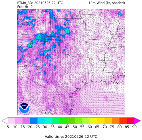
50 knots at 500 mb and 40 knots at 850 mb, turned almost 90 degrees with 3000+ CAPE is more than enough in late May. Some pockets will see 4000+ CAPE with excellent turning and speed shear. The 15% hatched is quite justified. Now, to the targets.

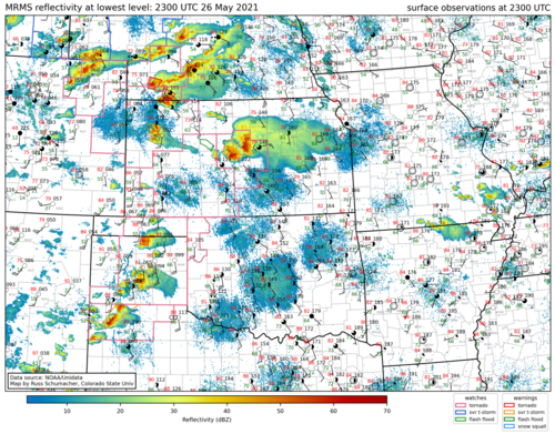
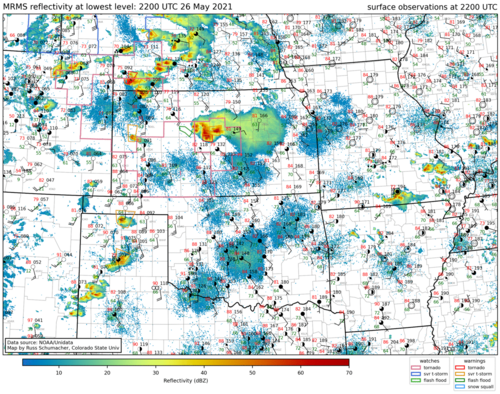
Warm front / outflow will lift up around I-70. It has been a focus for the CAMs several runs now. Winds will be backed and instability will be enough. Very slight cluster risk, but pattern recognition calls for supercells.

Dry line will push into southwest Kansas. Risk is warm 700 mb temps. However winds will be backed ahead of it with plenty of moisture. With today's parameter space I'd think both boundaries produce. Could even be a few other supercells.

I would pick one of the two said boundaries for possible cyclical supercell action, and perhaps multiple tornadoes.
 
Is it just me or is there a ton of variability in the models, not just CAMs but GFS vs Euro vs NAM and those compared to CAMs in placement of CAPE, certain composite parameters, even the strength of the 500mb flow and LLJ... Seems like a day to look at the “big picture” and focus on obs. Personally I am biased toward finding a reason to target SW KS because I plan to target the dry line tomorrow in the E TX PH / NW OK, but trying not to let that unduly influence what’s the best choice for today. Another consideration in comparing the two targets is the road network is better SW KS.
 
Is it just me or is there a ton of variability in the models, not just CAMs but GFS vs Euro vs NAM and those compared to CAMs in placement of CAPE, certain composite parameters, even the strength of the 500mb flow and LLJ... Seems like a day to look at the “big picture” and focus on obs. Personally I am biased toward finding a reason to target SW KS because I plan to target the dry line tomorrow in the E TX PH / NW OK, but trying not to let that unduly influence what’s the best choice for today. Another consideration in comparing the two targets is the road network is better SW KS.

It may end up being the better play. Ongoing convection with supercells near GLD "could" mess up the environment closer to the boundary on the northern end OR it lays down an OFB that later storms are able to interact with if and when the environment recovers prior to the afternoon/evening convective initiation east of the surface cyclone and downstream of the mid-level impulse. In the event of a possible fail mode further north, you definitely do have a more unmolested environment further down the dryline in that area. I would leave room for monitoring surface trends to keep both options in play BUT, from a chaseability standpoint, roads in the N target are definitely going to be saturated from convective activity the past few days, so that is definitely something to keep in mind.
 
There seems to be enough shear south to avoid going north, though storm motions will be fast so I'm leaning more toward southcentral Kansas - e.g. along US 183.

James I agree there is plenty of variability. For SW KS, the 16Z HRRR seems to be approaching the 12Z NAMNest, though the timing differs by several hours. Still, this increases my confidence.
 
Last edited:
Was going to start a REPORTS thread but I figured it would be ridiculous to do so when I have nothing good to report and my real interest is in figuring out what went wrong in SW KS yesterday. But MODS feel free to move if appropriate.

What a great parameter space to waste - e.g. 81/68 at DDC !?! Of course in retrospect I should have played the boundary to the north, but hindsight is 20/20 as they say. I saw some things I didn’t like on the models in SW KS, like a strengthening cap (but I thought the upper support and dryline would overcome it) and lowering dew points without any distinct dryline convergence. And some of the composite parameters up north were off the charts. But the dew points actually held up well in SW KS and were generally higher than up north most of the day, with favorable trajectories for continued advection of moisture out of OK. Surface winds were backed. The HRRR was variable with convection but there was a signal for initiation around Finney and adjacent counties. I was biased toward remaining south because I expected the northern boundary to keep lifting north, and I didn’t want to be out of range for Day 2, which in retrospect was stupid, like giving up $100 to get $5. Also better road network south. At one point I actually did head out from GCK to Colby, but I stopped in Scott City, talked to some other chasers, and in the process convinced myself my initial preference for SW KS was correct and went back south, even standing my ground in GCK and foregoing the cell that went up in Leoti.

As it turned out, I went after a cell that went up between Sublette and Mead at around 7pm. The storm split, but both cells continued moving NE. I was able to get between them and chose the northern cell; neither one looked that great, but the northern one was heading toward DDC and I had a better intercept position and route relative to it, coming up through Montezuma and Ensign. And it’s not as if the southern storm was a right mover. Anyway, they both died.

I assume the cap was the main culprit in SW KS. But not sure why the TX PH, where 700mb temps were also warm, produced, maybe due to a more pronounced dryline bulge?? Was SW KS in a region of subsidence between the northern activity and the TX PH activity??
 
I assume the cap was the main culprit in SW KS. But not sure why the TX PH, where 700mb temps were also warm, produced, maybe due to a more pronounced dryline bulge?? Was SW KS in a region of subsidence between the northern activity and the TX PH activity??

I suspect the convection in the TX panhandle disrupted the convective environment further north into SW KS. There was also some cirrus present that could have played an ancillary role too, and you can watch a WV loop from about 21z onward to see how that pushes north from the PH.

The 00z/27 DDC RAOB does indicate some marginal CIN around 1400m, but yet so does MAF.

That was a pronounced dryline bulge in the TX panhandle between 22z and 00z/27. The was a notable region of PVA that moved over the TX PH from 17z - 21z as evidenced by the RAP 500mb Abs. VA UA profile.
 
Everything Jesse says helped Texas go.

Southwest Kanas seemed caught between waves. The warm nose could have been overcome with ease, if some lift. Unfortunately slight subsidence was over southwest Kansas. HRRR zig-zags were the first hint. We laugh at the HRRR, but those mid-morning runs apparently turned out right, blanking southwest Kansas.

NAM convected southwest Kansas but obviously blew the lift forecast. ARW went mixed mode in a hurry up in Nebraska. That was wrong. CAMs struggled because it's not a true synoptic set-up.

As we get into June it will be pattern recognition season. Boundary intersections, terrain, etc.
 
My sense of the failure of CI in W KS was that it was a really close call. I don't think there was much keeping it from really going, but unfortunately, the state of the science is such that a tiny perturbation can make a huge difference in larger-scale atmospheric behavior, and our observation systems are not capable of resolving such perturbations. (plus, instrumentation and measurement have errors that cannot always be neglected)

I suspect there was slightly more MLCIN in SW KS than might have been indicated or guessed, and also that surface forcing for convection was weaker there than in other locations that did see CI. But it wasn't by much. It could also be that mid-level temps and UA support were weaker to the south, so without sufficient forcing off a boundary, CI was less likely there. Perhaps also the dryline circulation was weaker in SE CO/SW KS...*shrug*

There are a number of sources you can use to analyze the situation at the time. I love how GSL makes 3D_RTMA imagery available for quite some time after analysis, and offers a large number of products. Try this:


I also noted the HRRR's apparent failure to capture most of the CI and evolution yesterday. Attached is a dprog/dt of reflectivity from several HRRRv4 cycles at 22Z. The final frame has a longer delay and essentially shows observations. Even the 21Z HRRR forecast (initialized just as the tornadic storms in far SW NE were firing) did not capture them.

FWIW, WoFS struggled yesterday, too. In fact, you can view those forecasts for free, also. Feel free to play around with it here: WoFS - Realtime Viewer

The 19Z and 20Z forecasts caused me to turn around when I was in Flagler, CO just before 21Z. I probably could have made the NE tornadoes if I had known they would be there. But if you know the future, the science becomes moot. 🤪
 

Attachments

  • Screenshot_2021-05-27 One-week archive base reflectivity mosaic and surface observations Russ ...png
    Screenshot_2021-05-27 One-week archive base reflectivity mosaic and surface observations Russ ...png
    1.1 MB · Views: 0
  • Screenshot_2021-05-27 One-week archive base reflectivity mosaic and surface observations Russ ...png
    Screenshot_2021-05-27 One-week archive base reflectivity mosaic and surface observations Russ ...png
    1.2 MB · Views: 0
  • wspeed_SC_10m_f000.png
    wspeed_SC_10m_f000.png
    771 KB · Views: 0
  • NEXLABdpdt-22Z-20210526_HRRRCGP_prec_radar-50-200.gif
    NEXLABdpdt-22Z-20210526_HRRRCGP_prec_radar-50-200.gif
    3.2 MB · Views: 0
Back
Top