• A friendly and periodic reminder of the rules we use for fostering high SNR and quality conversation and interaction at Stormtrack: Forum rules

    P.S. - Nothing specific happened to prompt this message! No one is in trouble, there are no flame wars in effect, nor any inappropriate conversation ongoing. This is being posted sitewide as a casual refresher.

2021-04-23 REPORTS: AR/LA/MS/OK/TX

Randy Jennings

Supporter
Joined
May 18, 2013
Messages
767
Initsl target Vernon TX to play the triple point. Most folks headed toward the cell that fired near Childress, but we went towards Crowell and wIsited n southern Foard Co.. The Childress cell got svr then tor warned but we held fast for an hour and our cell finally became svr warned.and we ended up getting hail about 2 inches and found some latter that was 3.5 inches. Here is my chase partner with some hail up to 3
5 inches.

1619242261290.jpg

We went northeast to the northern cell and intercepted it near Lockett TX where it produced a beautiful cone tornado. I think by the end of the day we had technically seen 4 tornados total.

1619242751649.jpg

Here is a video:

 
What an incredible chase yesterday in northwest Texas south of Vernon! This was a top 5 chase for me. I departed Tulsa at 11am and originally targeted Quanah, TX. As I crossed the Red River near Burkburnett, TX I noticed temps in the low 60s. I met my friend and longtime chase partner Casey Zandbergen (I am still chasing solo due to the pandemic) in Vernon, Tx. Temps in Vernon were in the low 70s. We sat in Vernon for a while and watched satellite and radar as cells began developing on the dryline. One particular cell south of Childress had our interest because it was in close proximity to the triple point. At first I was concerned it may cross the warm front into southwest Oklahoma and become elevated, however the slow movement of the storm made it apparent it had a solid chance of latching onto the warm front. We decided this was the storm we wanted to go after so we headed west to Quanah then south on HWY 6 until we were in the direct path of the storm then stopped and waited for it to approach. Road options to the west were very limited, so we decided to be patient and let it come to us. The storm gradually organized as it approached, and by the time it reached HWY 6 an intense mid-level inflow band was arcing into the meso from the southeast while another intense inflow band was feeding the base of the updraft from the north.

Casey and I became separated in the chaser circus. I dropped south on HWY 6 to county road 3103 and took that east, merging onto HWY 98. The first tornado formed to my north and was rather low contrast. I stopped to take a few photos then continued east. A second needle tornado formed east of the first tornado, and this tornado was also low contrast from my vantage point. A few minutes later the storm cycled again and produced a pair of tornadoes under a large rotating meso. I was able to capture quality images and video of these tornadoes. A few minutes later another tornado formed to my northeast, and this one had incredible contrast and had a textbook cone shape. The tornado was front-lit and the funnel was white with a red debris cloud. A gorgeous rainbow also appeared next to the tornado. This took the chase experience to the next level. After this tornado dissipated, I continued east on 98 and stopped to let a new circulation cross the road immediately in front of me as it drifted southeast. Copious amounts of rain were wrapping into the circulation which made for poor visibility from my location in the hook. I dropped south then east on road 433. Another tornado had formed just to my southeast, however I didn't notice it immediately because of the heavy rain obscuring my view. Once it came into view I could see it was hitting a structure as it lofted a lot of debris in the air. I turned east on 433 and stopped next to a damaged house. Here I hopped out and focused on taking photos of the tornado as it began to rope out to my southeast. I just happened to stop next to a windmill and took full advantage of the composition. I ended up capturing images of the rope tornado in between a damaged tree and a windmill with a rainbow next to the tornado. This would quickly become my all-time favorite set of images.

This chase is a top 5 all-time chase for me. Multiple photogenic tornadoes made this event extra special. Congrats to everyone who scored today. Hopefully 2021 is just getting started.

20210424_132815.jpg
20210424_132718.jpg


20210424_132755.jpg
20210424_132657.jpg
20210424_132738.jpg
 

Attachments

  • 20210424_132633.jpg
    20210424_132633.jpg
    458.8 KB · Views: 0
Last edited:
Solo chase day, my fourth ever and the first to feature tornadoes. Targeted the triple point at Childress and arrived around 1400 local, short on sleep but high on optimism (decision to chase had been made at 1900 the night before, two time zones back in Tucson, AZ). Childress was still under a broken stratus layer at this point and was a clammy 62F, but a broad area to the southwest around Turkey and Quitaque had long since cleared and warmed, so it was no surprise when the first cell fired there around 1500 and began tracking E/ENE. Two other cells also rose at the same time to the SSE, but they looked noticeably more ragged on satellite and moreover the most favorable shear I knew would be around the surface low, so I stuck with the first, northernmost cell. At this point I felt that it might not have time to organize before reaching the Childress-Paducah axis, so I actually slid 20 miles eastward down U.S. 287 to Quanah to receive it.

Noted an improving rain-free base and an inflow band from the new position outside Quanah (on my first few chases I had made the rookie mistake of getting too close and not being able to pick out such features; I made a concerted effort to stay zoomed-out today and it was very helpful), as well as strengthening rotation on radar. As the cell approached, had the option to move south and watch it pass by to the north, or move east and stay well ahead / northeast of the area of rotation. Chose the latter since I didn’t want to end up behind the storm on the sparse road and cell data network, and the highway seemed like it would remain a good place provided storm mode continued to be LP. This worked out well because the pattern basically became: get beaned by the first hailstones - drive a few minutes east on 287 - get out, look to the southwest, observe tornado touchdowns - get beaned by hailstone - repeat.

Witnessed at least five distinct touchdowns (I actually lost count), all of which were brief, and all from highway 287 or within a half-mile of it, looking south or southwest. As the cell drifted east the structure became increasingly dramatic, ultimately ending up a spiraling, sculpted birthday cake around Vernon. Observed one more white, sunlit cone from east of Vernon but the rotation seemed to dissipate thereafter with the cell absorbing other convection nearby and beginning to cross the Red River into OK. Abandoning the storm was the only time I encountered bad chaser convergence, as people who were positioned to the south were scrambling to stay caught up using a couple of narrow farm-to-market roads whose shoulders had just been turned to mud and melting hail pits. Previously, by staying northeast and close to the four-lane highway there had been plenty of room for all, and the gentle storm motion meant the pace was unhurried.

Never got particularly close to any tornadoes (wouldn’t have been a bad day to try) but that did not concern me, as the structure was jaw-dropping LP and moreover these were my first tornadoes ever, a lifelong dream. This feels like it would still count as a banner day even if I chased much more often than I do. The only regret was getting briefly caught by ping-pong-ball-sized hail outside Vernon and adding some dimples to my car. Sorry car.

4BF9FE79-5A52-404E-9443-EC4261BE60DF.jpg
^mothership over Vernon
DF7EB1C4-AFCE-4543-89F7-C9C28410F702.jpg
^first tornado of the day / of life
timelapse still.png
^still from a timelapse as structure was starting to ramp up near Vernon
 
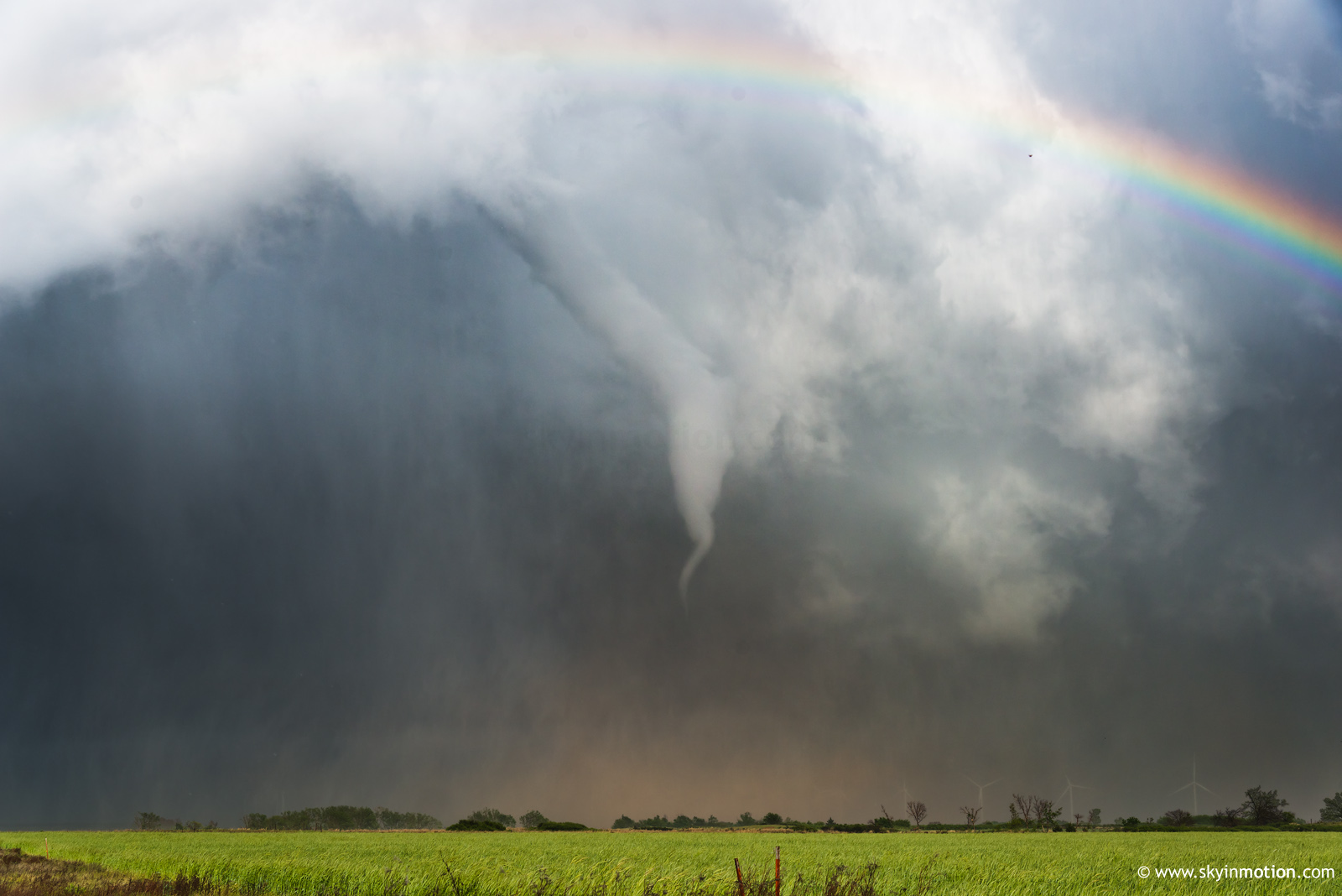
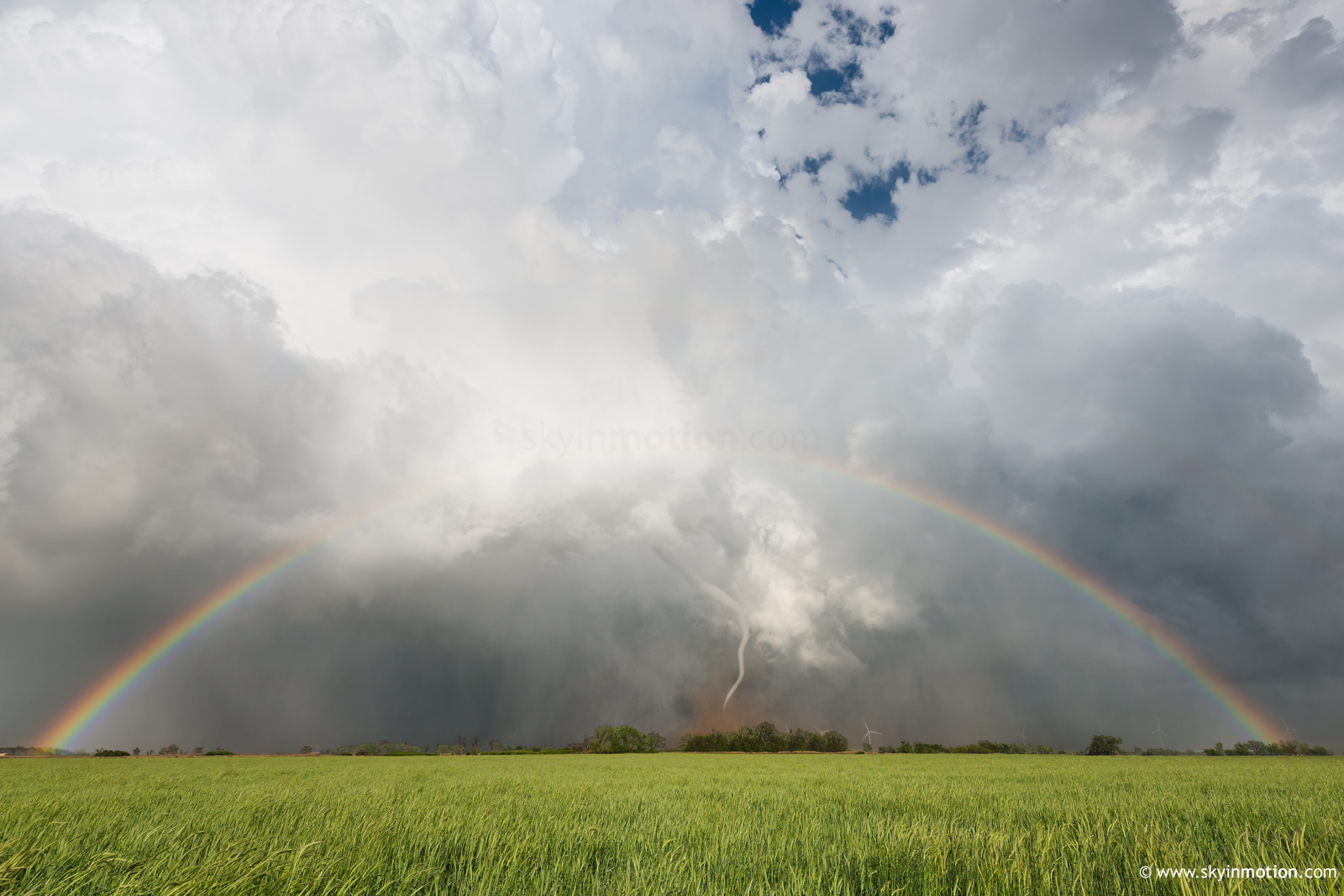
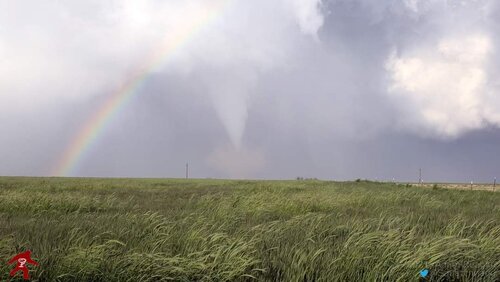
^ That rainbow + rope tornado + windmill pic is amazing.

What a day yesterday and one that will probably remain in my top 5/top 10 chases for a very long time. Started off the day in Norman targeting Quanah, TX with the expectation that the cold temperatures underneath the trough base, good shear, and adequate low-level moisture would yield robust updrafts near the triple point. We were mostly socked in with stratiform until we reached Altus and turned southwest on OK 6 towards the Red River. About 2-3 miles south of town, we broke out into nearly full sunshine near/south of the warm front and temperatures jumped into the low 70s. The storm that would eventually become the tornado machine was already ongoing near Childress and the core was moving in our direction so we decided to bail south a bit on TX 6 instead of east on US 287 (a good decision considering the multitude of >2" hail reports from that area later).

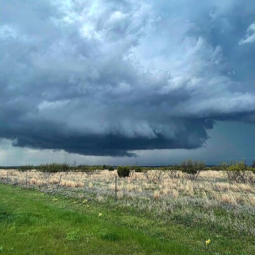
Eventually we came to a position across from the entrance of Copper Breaks State Park and watched the storm approach, with intermittent wall clouds and scud rising into the base. A funnel cloud was also present for a short time as inflow really began to increase from the ESE, which was warm despite gusts exceeding 35 mph. There were all kinds of inflow bands and other laminar features racing into the updraft at this point from multiple different directions in the low-levels, including evidence of the streamwise vorticity current, and that told me that something interesting was likely going to happen. Large 0-3 km CAPE and substantial near-surface vorticity was helping to overcome some of the weaknesses in the low-level wind field in terms of strength, and it seems that boundary/storm-scale interactions were also occurring, both with the cell immediately to the south and the one that developed in behind (e.g. Cameron Nixon's tweet while the event was going on).

DSC_0310 copy.jpeg

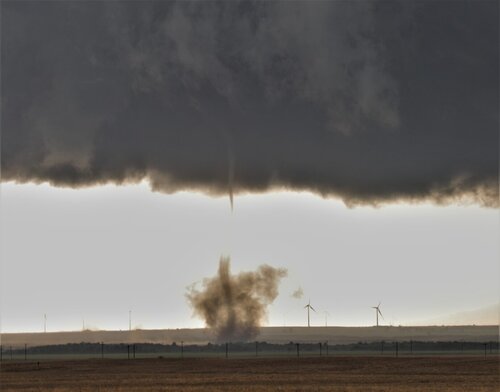
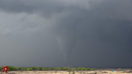
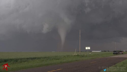
Ariana and I both agreed that we needed to drop south as the chaser caravan moved into the area from the north. No complaints from me in terms of behavior yesterday despite the number of people on the storm by the way, people were doing the right things as far as pulling off the roads/etc. We crossed the Pease River and found FM 3103 north of Crowell to take us east and parallel the intensifying mesocyclone to the south. Sometime after that (around 5:45 PM CDT IIRC), Ariana spotted the first tornado of the sequence in its weakening phase partially hidden against the dark background and we pulled off to watch it occlude. A second rope tornado formed not long after the dissipation of this one (unless it was simply the same tornado lasting longer than we were able to continuously visualize).

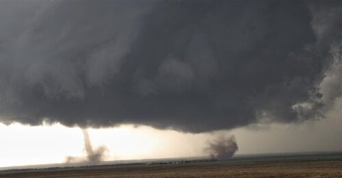
By this point, motion in the wall cloud and along the forward flank became very intense, and we were able to visualize the RFD punch/cut coming around the back side and streamwise vorticity current rising almost straight up into the updraft at nearly a 90˚ angle, which was amazing to see visually. Not long after that was the period where the "Simla anticyclonic look-alike" and eventually twins happened looking north from FM 98. We would've certainly been satisfied with this as the whole chase...

DSC_0334 copy.jpeg

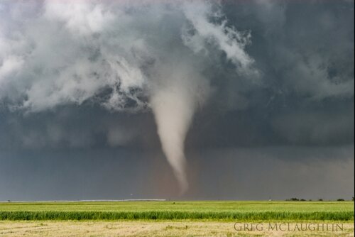
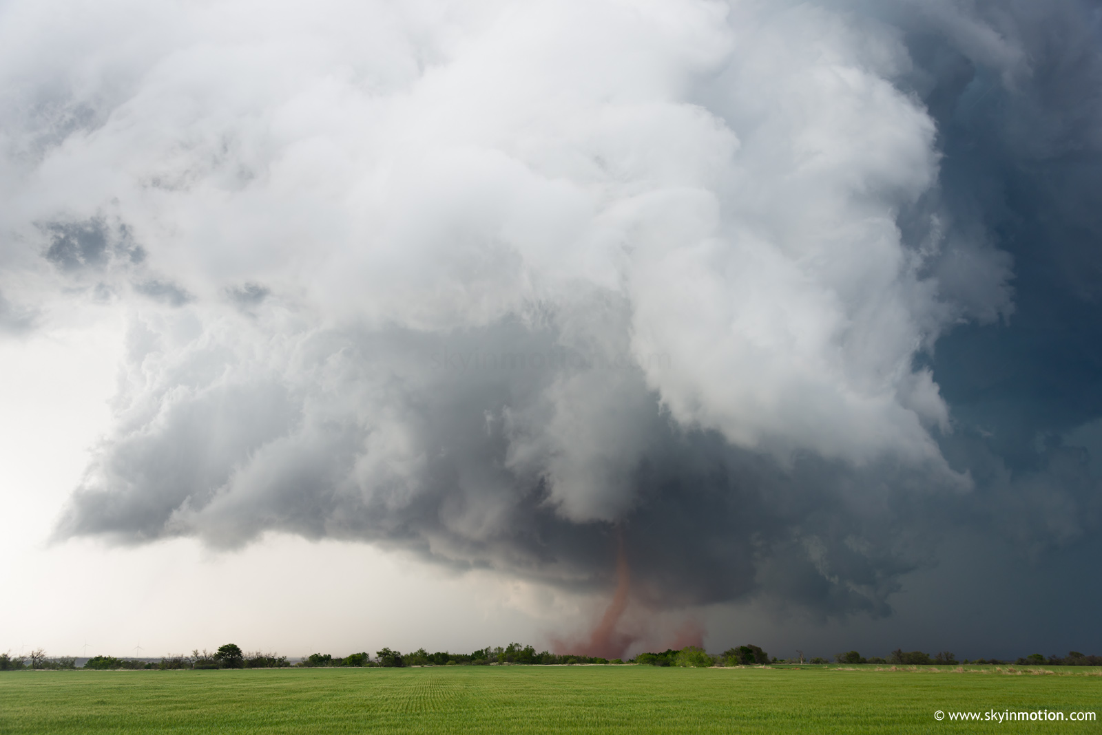
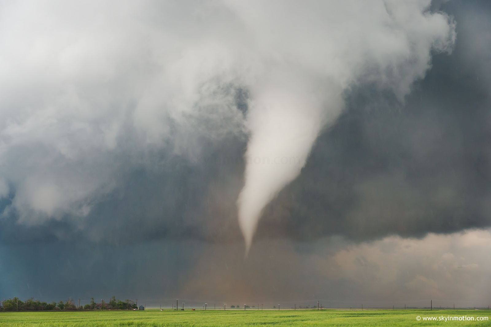
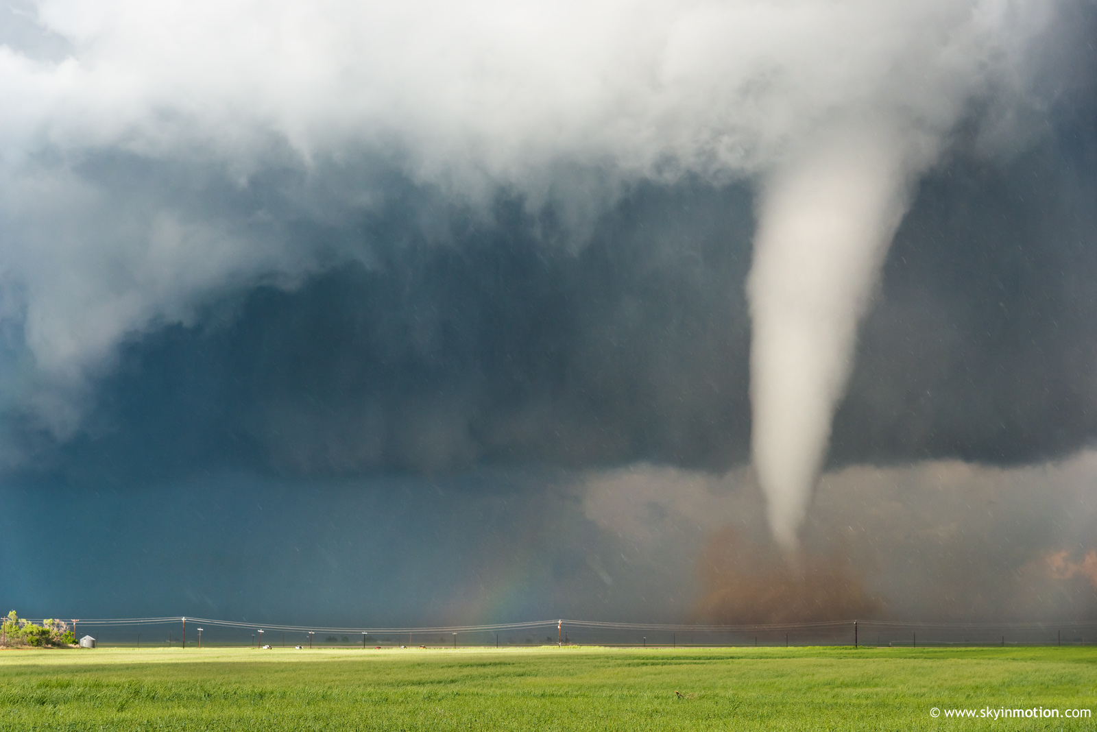
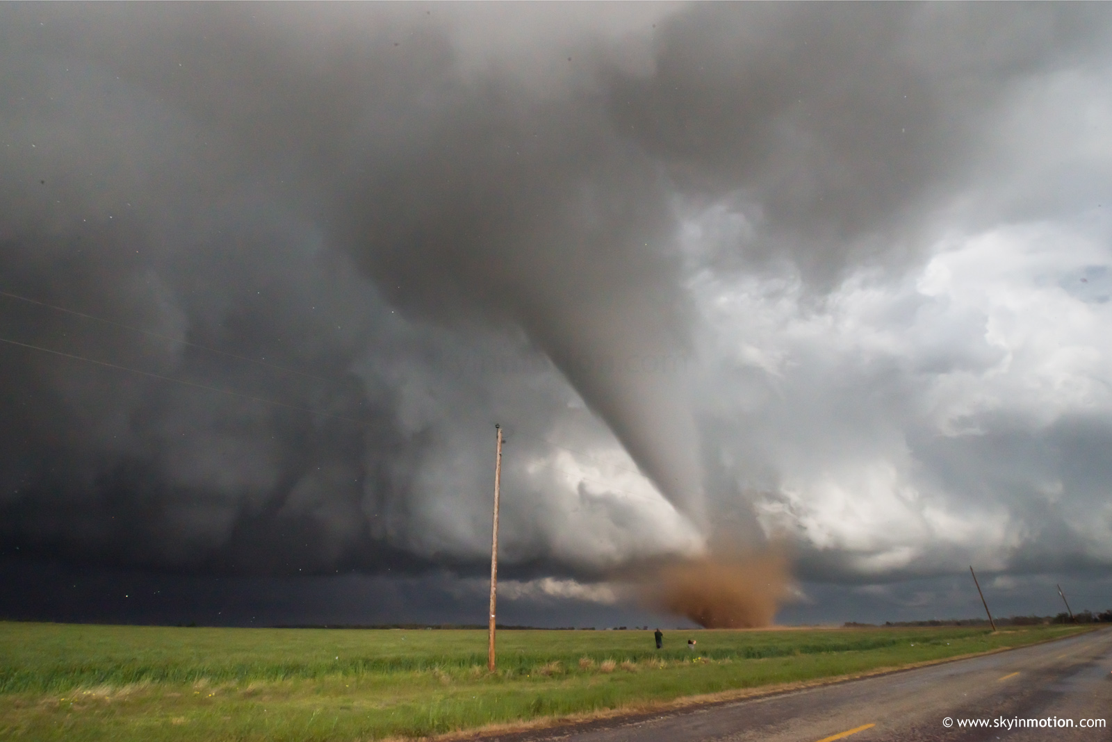
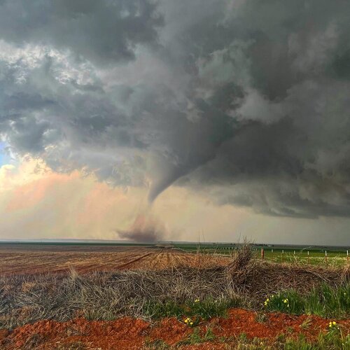
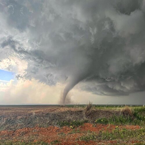
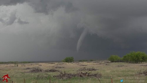
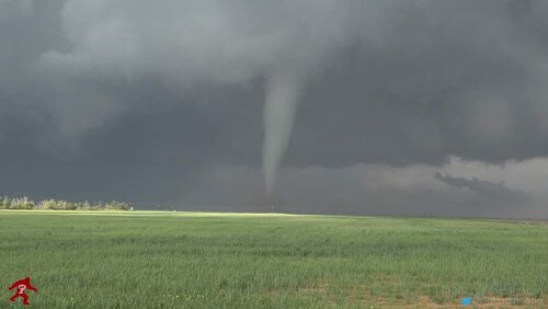
...Little did we know that the greatest part of the show was still coming as the storm cycled once more as we jumped on US 70 and stopped across from the Western Trails Cowboy Church (how Texan is that, eh) west of Lockett. This was in time to watch the evolution of the spectacular 4th/5th tornado of the sequence (depending on what happened with tornadoes #1/#2). Ariana got a few absolutely phenomenal pictures during this time as the tornado moved ESE around 1/2 to 3/4 of a mile away. It looked fairly strong and destroyed an outbuilding at one point. This was certainly the best tornado I've seen since the Dodge City day in 2016, and I got better pics this time around. It reminded me quite a bit of a combination between the white Hill City KS stovepipe on 6/9/2005 and the Bryce TX/Palo Duro Canyon tornado on 3/28/2007 with the red dirt. As the tornado passed to the east (see the second photo of it below with rain, small hail, and the occasional tumbleweeds rolling by) and eventually weakened after about ten minutes, I noted how warm the RFD was, with a ∆T of only around 3-5˚C between it and the inflow air.

DSC_0349 copy.jpeg

DSC_0376 copy.jpeg

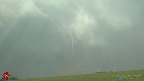
We made our way through the town of Lockett to get ahead of the mesocyclone and RFD again, and about five minutes later I took a look in the rearview mirror to notice the cone-shaped funnel cloud that would become the last tornado of the day forming. Again complimented by a shower of red dirt in the debris cloud, the tornado unfortunately moved into portions of town and sent debris flying (glad to know that no one was hurt). Unlike the other tornadoes prior, we had the backlit view of this one, with blue sky in the background as the tornado went through a lengthy occlusion and rope out, with windmills in the foreground.

DSC_0387 copy.jpeg

DSC_0412 copy.jpeg

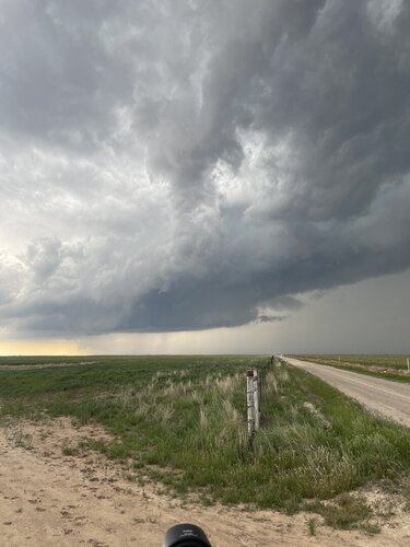
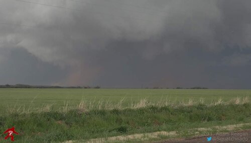
Following this, the storm began interacting with others to its south and assumed more of a stable look to its base, so we made our way to US 287 at Harrold in order to get back towards Wichita Falls and I-44, hopefully to get some structure pictures in the progress, but we found it difficult to find a better angle that was not impeded by low-level cloud cover. We decided to call the chase and grab takeout in Wichita Falls (which was promptly interrupted by a hail storm and we were forced to wait inside Chipotle). Finally, we left Wichita Falls at about 10:00 PM and got quite a lightning display heading north/northeast from Grandfield to Lawton, including several close positive CGs that Ariana got on video. Arrived back in Norman before 11:30 PM exhausted, but adrenaline still pumping.

What a day, and one that neither of us will ever forget. Her first true A+/top 5'er chase day and my first since 2016. Congrats to everyone else who scored! That was a storm that looked great from basically any angle and from any distance. Have seen various amazing vault + tornado shots from ahead, rainbows + tornadoes from behind, etc.
 
Friday marked my first successful tornado chase and it was quite a day. Started the chase just west of Quanah and was among the chaser caravan as it followed FM104 E, TX6 S, FM 3103 E. The first image at left was taken near Margaret. Then continued on FM 90 and US70 E past Lockett to FM433 where the second image in center was taken. The final image at right was taken on US183 as it was roping out.
1619365925404.png1619366228178.png1619366389236.png
 
Left around 2 and made it to Crowell by 5. I was very ambivalent about latching onto the northern storm as I watched it approach from the WNW, given the cold look along the baroclinic zone and surrounding low clouds. In fact, I started to meander S back toward town multiple times, only to think better of it -- mainly because the southern cells never looked serious about taking off. Thank goodness they didn't, or I quite possibly would've blown the redemption opportunity I've been waiting for since 2016.

Video (mainly TORs #1-3)


TOR #2-3 (dusty whirls) E of Margaret

2021-04-23_0003.jpg


TOR #4 at Rayland

2021-04-23_0035.jpg


2021-04-23_0048.jpg


TOR #5 E of Lockett

2021-04-23_0056-1.jpg


2021-04-23_0082.jpg


2021-04-23_0093.jpg


It's been a rough stretch of chasing for me -- and I know for a lot of you, too -- the past several years. Congrats to everyone out Friday; especially newer folks who've had to endure endless scarcity since they started. Let's hope this is only the start.

One logistical comment: I've been suspicious the past few years that some extended data outages I encounter are the direct result of chasers overloading towers, and I think that was all but confirmed on this event. I went almost a full hour without a single radar update through Verizon starting toward the end of TOR #1, after having zero issues beforehand (even wandering 5-6 mi. from pavement NW of Crowell). It is what it is, but it's pretty frustrating, and could've been far more so on a messier storm! I'll second what Andrew said above in that the hordes, while also somewhat irritating logistically (waits to pull back onto road), were well behaved overall.
 
Initially targeted Quanah TX. Got there and saw the Childress storm had formed, as well as a few others to the south that were starting to go up. Decided that the storm was slow moving, so decided to go west on 104 west of Lazare. Got to 1033 and decided that there weren’t great road options to the south to get back east, so sat around that intersection. At that time, there were only 2 other chasers there. At that point, you could see the wall cloud that formed and the storm went tornado warned. It was still trying to get organized, and thus the wall cloud kept dying and trying to reform. Waited there about 15-20 minutes and about 20+ other chasers were at the same area, so since the hailcore was getting close, I decided I didn’t want to get caught up in traffic and left. Went back east in 104 and snapped the 1st picture below of the structure of the storm.

Ultimately went back to Quanah and dropped south, stopped a few times to watch it getting organized, then went to Copper Breaks State Park stopped and saw a rapidly rotating wall cloud and knew this was about to produce (2nd photo). I believe I caught a funnel out of it, but it was hard to tell and then I got blasted by the RFD and wind driven hail. At this point, HW6 was filled with chaser convergence to the south, and I debated whether or not I should just wait there, because in my mind it was about to produce, or go east and get ahead of everyone and hope it produces in 20 minutes. Decided to go east with everyone else, and saw out my window that it formed a tornado. Others were stopping but I decided to continue east towards Lockett. Ended up on HW70 SE of Ryland and pulled over and saw several tornadoes, including 2 at the same time (4th photo). Ultimately the larger stovepipe touched down about 1.5 miles to my NNW, and ended up passing about a mile away to my north. Saw it hit a structure as the debris went flying into the air. Watched it rope out. Because everyone else was taking 70 east, I decided I’d go and see what structure it hit. Saw a destroyed barn but couldn’t see any buildings that were hit. Didn’t want to risk going down some roads that looked like driveways and get stuck, so I called off the chase and went back to OKC.

All in all, this was definitely the best chase I’ve had.
 

Attachments

  • FA74A796-0A22-48BD-B828-16A4AE17C6C5.jpeg
    FA74A796-0A22-48BD-B828-16A4AE17C6C5.jpeg
    129.2 KB · Views: 0
  • 07A38324-B2CF-48E5-8926-6DC0CAC36204.jpeg
    07A38324-B2CF-48E5-8926-6DC0CAC36204.jpeg
    276.2 KB · Views: 0
  • DD816BDE-D96F-426F-B4B2-591302144577.jpeg
    DD816BDE-D96F-426F-B4B2-591302144577.jpeg
    73.9 KB · Views: 0
  • 23A0732B-3329-459D-B4C0-22CCC7788C25.jpeg
    23A0732B-3329-459D-B4C0-22CCC7788C25.jpeg
    94.2 KB · Views: 0
  • CE29219B-7F6C-4A3B-AEDC-50DA276EC8BC.jpeg
    CE29219B-7F6C-4A3B-AEDC-50DA276EC8BC.jpeg
    219.7 KB · Views: 0
  • 2152B24B-F979-4907-B53E-56869A78E953.jpeg
    2152B24B-F979-4907-B53E-56869A78E953.jpeg
    234.1 KB · Views: 0
  • 7C3BE2BB-1974-4D34-A4F6-3E3BE915FEA2.jpeg
    7C3BE2BB-1974-4D34-A4F6-3E3BE915FEA2.jpeg
    179.3 KB · Views: 0
After a lackluster 2020 chase season with no tornadoes to show for it, my tornado drought ended in spectacular fashion on this day.

This was one of my best chases ever, one I almost missed because I didn't think I would be able to get out of work in time. I ended up seeing 5 tornadoes including twins. My favorite shot was the white tornado with the rainbow in the foreground southwest of Vernon.

My video from this chase:
 

Attachments

  • FB_IMG_1619273286496.jpg
    FB_IMG_1619273286496.jpg
    19.4 KB · Views: 0
  • FB_IMG_1619273290459.jpg
    FB_IMG_1619273290459.jpg
    31.7 KB · Views: 0
  • FB_IMG_1619273296627.jpg
    FB_IMG_1619273296627.jpg
    36.3 KB · Views: 0
  • FB_IMG_1619273299484.jpg
    FB_IMG_1619273299484.jpg
    23.4 KB · Views: 0
  • FB_IMG_1619273303154.jpg
    FB_IMG_1619273303154.jpg
    33.6 KB · Views: 0
  • FB_IMG_1619273306200.jpg
    FB_IMG_1619273306200.jpg
    54 KB · Views: 0
  • FB_IMG_1619273309254.jpg
    FB_IMG_1619273309254.jpg
    12.9 KB · Views: 0
Back
Top